![]()
Cycling Blue Mountain
![]()
Blue Mountain stands at an elevation of 6,004 feet (1,830 meters) and is located within the Daniel J. Evans Wilderness in Olympic National Park, Clallam County, Washington and is situated 13 miles southeast of Port Angeles and 11 miles southwest of Sequim
![]()
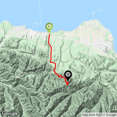
The full climb begins in Port Angeles 8.8 miles from the start of the gravel climb.
![]()
Munitions sign on the paved route to the start of the gravel climb.
The Port Angeles Combat Range was used by the military primarily during World War II. The range was intended for tactical firing problems and short-range known distance firing (200 to 300 yards). Weapons practice included the use of 37mm and 75mm projectiles, 60mm and 81mm mortars, and various small arms. There are also reports of mortars and land mines being. In August 1948, a tragic accident occurred when two boys were killed by the explosion of a 37mm shell embedded in a log they were sawing. This incident prompted multiple range clearances by the Army.
Initial clearance efforts took place from October 1948 through January 1949, with subsequent clearances in 1952, 1955, 1956, and 1957. On May 7, 1949, a Certificate of Clearance was issued, noting that approximately 775 acres had been cleared of dangerous/explosive material. Despite this, the exact locations of these investigations were not well-documented.
In 1963, the Army repurchased 652 acres of potentially contaminated land to restrict access following the UXO accident. This land was retained by the Army until 1967, when it was transferred to the City of Port Angeles and a private individual, with a "surface use only" and indemnity clause included in the quitclaim deed records.
![]()
Deer Park Road transitions to gravel at mile 8.8
Climb summary by PJAMM’s Brad Butterfield.
I started the climb in Port Angeles on Deer Park Road, which intersects with Hwy 101 - the main vein through this part of WA. For the first 10 miles, the gradient is easy and the road is paved. Houses and private roads line this part of the climb. Around the 9 mile, the climb turns to gravel, marked by a large gate which is presumably closed during the winter season when the road is not passable. There was a constant flow of traffic for the entire time I was on this road - this is a very popular tourist destination, expect to breath in a lot of road dust.
![]()
Examples of the road surface on the climb - this is a well maintained roadway.
Once the road turns to gravel, the real climb begins. It becomes steep, then gets steeper, then even steeper still. IT is a VERY difficult climb and I would strongly recommend coming with low gearing. Though most of the gravel road is hard packed and in great condition, there are notable stretches of loose gravel on steep grades.
![]()
We encountered a fair amount of wildlife on our trip to Blue Mountain Summit. I addition to rabbit and several deer, you may also see the Olympic Marmot, Roosevelt Elk, Black Bears, and Bald Eagles.
![]()
![]()
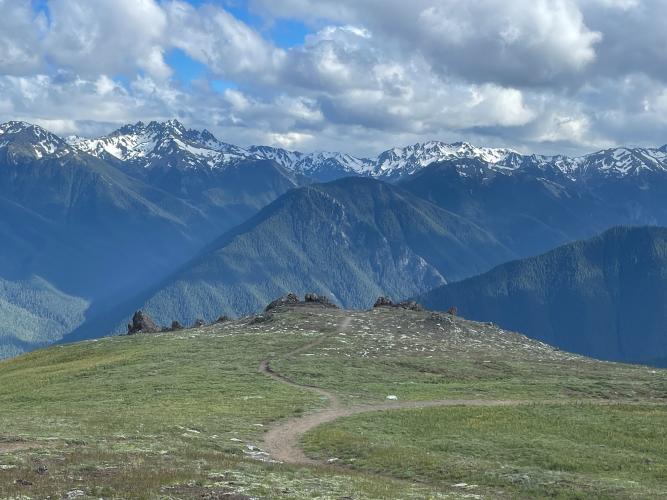
The last few miles of the climb are phenomenal. Panoramic views of the surrounding Olympic National Park make this section of road unforgettable.
![]()
![]()
Deer Park Campground is one mile from the summit
We camped at Deer Park Campground for $9.00 as of June, 2024. Deer Park Campground is situated at an elevation of 5,400 feet along the treeline of Blue Mountain in Olympic National Park. The campground is rustic, featuring 14 sites with fire pits, picnic tables, accessible pit toilets, and animal-proof food storage. There is no potable water available, and firewood gathering is prohibited.
![]()
Trail short trail from the Blue Mountain Trail Head parking lot three tenths of a mile from the summit.
1 mile from the summit, you’ll reach the National Park campground. Stay left on the road here and it is about .6 mile to the end of the road - but not the end of the climb. There is a large parking area at the end of the road, which was very busy when PJAMM rode this climb in June 2024. Many folks drive the road, park here, and walk the final .3 miles to the summit. The hiking trail to the summit is easily rideable on a gravel bike. At the summit, you’ll have views of the edge of the United States, the Canadian Coastline, and the massive peaks that define the Olympic National Park.
![]()
The finish is near the hairpin bottom center of photo left and bottom right photo to the right.
![]()
Weather station at Blue Mountain Summit.
![]()
From Blue Mountain Summit we can see the Olympic Mountains, including Mount Olympus, Strait of Juan de Fuca to the north and on a clear day the San Juan Islands to the northeast.
![]()
![]()
Mount Olympus as seen from Blue Mountain Summit.
Mount Olympus is the highest peak in the Olympic Mountains, standing at 7,980 feet (2,432 meters) above sea level. The mountain supports several large glaciers, including the Blue Glacier, Hoh Glacier, and others. These glaciers contribute to the mountain's rugged and dramatic appearance.
From the summit of Blue Mountain, you can also see other notable peaks in the Olympic Mountain Range, including:
- Mount Constance: Known for its prominence and visibility from the Seattle metropolitan area.
- The Brothers: A double peak visible from Seattle, known for its distinctive shape.
- Mount Deception: The second-highest peak in the Olympic Mountains.
- Mount Anderson: Known for its glaciers and significant elevation.
- Mount Angeles: A prominent peak near Hurricane Ridge.
![]()