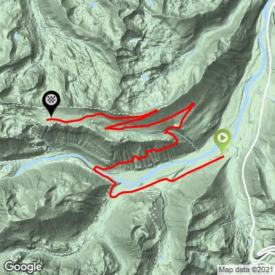
Mt. Rainier (Sunrise VC) Bike Climb - PJAMM Cycling

14
PDI
14.2 mi
DISTANCE
3,070 ft
GAINED
3.9 %
AVG. GRADE

FULL CLIMB STATS

Page Contributor(s): Steve Jones, Olympia, WA, USA

INTRO

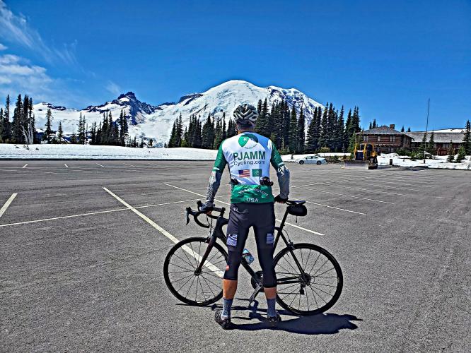
"Sunrise is a dramatic climb within Mount Rainier National Park southeast of Seattle. In thick trees down low, near the top of the route great views appear. It carries a steady and moderate grade over most of its length as well. There is a little bit of traffic on this road most days. Toward the top the grade eases and the final segment heads straight toward mighty Mount Rainier and the views are spectacular, ending at the top of the parking lot as the highest paved road in Washington (closed in winter - Mount Rainier National Park - 360-569-2211)." (This quote is presented with the approval of John Summerson, from his book, The Complete Guide to Climbing (by Bike), 2nd Edition, pg. 228.)
3.9% average grade (4.6% climb only).  10% of the ride is descent, 53% is at 0-5% grade, 35% is at 5-10%, and 2% is at 10-15%.  The steepest quarter-mile is 8.9% and steepest mile 6.6%. 

See more details and tools regarding this climb's grade via the “Profile Tool” button.
Roadway:  Two lane road in good condition with no shoulder and a center line (sometimes double yellow, sometimes broken yellow). 

Traffic:  Mild to moderate.

Fee;  There is a fee to enter the park on bike ($15 as of 2020).  Check out the NPS.Gov Fees for Mt. Rainier NP website for more information.

Parking:  Park at the White River Ranger Station at the start of the climb (MapStreet View), or, if you don't want to pay extra for a vehicle, park on the side of the road before the entrance gate a half-mile before the entrance (MapStreet View).
Provisions:  None on the route.  There is no lodging at Sunrise like at Paradise Visitor Center, but Rainier Guest Services operates a snack bar serving hot meals and a gift shop at its day lodge at Sunrise (Rainier Guest Services).
Before heading out on any cycling adventure check out our Things to Bring on a Cycling Trip and use our interactive check list to ensure you don't forget anything.
This climb ends at the Sunrise Visitor Center so be sure to spend time there and take in the beauty surrounding you, including the mighty Mt. Rainier to the south (Google Map + Reviews for Sunrise VC). For hikes in the park, see All Trails Best Trails in Mount Rainier NP.  

Use the “Routes in Area” button on the menu bar to see other bike climbs in this area, including the very popular Mt. Rainier (Paradise).

ROUTE MAP

MEMBER RATING

Difficulty: Moderate
4
Road
4
Traffic
4
Scenery

CURRENT WEATHER

PJAMM TRIPS ADVENTURE STARTER BUNDLES

Check out PJAMM Adventure's prepackaged (self-guided) cycling trips. They will help you plan, document and conquer your next adventure.
ALL TRIPS
Browse all of our prepackaged trips and find your next adventure!
Olympic NP: Hurricane Ridge
United States (WA), Canada
8 ROUTES
19 POIs
ROUTE STATS (TOTAL)
125
mi
DISTANCE
14,009
ft
ELEV. GAIN

NEARBY CLIMBS (0) RADIAL PROXIMITY

FROM
No Climbs Found

MEMBER REVIEWS & COMMENTS

Let us know what you thought of this climb. Signup for our FREE membership to write a review or post a comment.
Already have an account?

Jun 24, 2024
difficulty: Moderate
scenery: 5
traffic: 5
road: 5
Jun 24, 2024
scenery: 5
traffic: 5
road: 5
The rating is for when the road is still closed to cars. Cyclists can access the road all day on the weekends and federal holidays. Friends tell me that one can also can through the gate at White River Campground during the week IF they arrive before 07:15 when road workers arrive OR after 16:00 when they go home for the day. The best time to do this is then from about late April to late June. In 2024, the road will open to cars 1 July (it varies from year to year so check with NPS on when it will open exactly)
Jul 30, 2021
difficulty: Moderate
scenery: 3
traffic: 3
road: 3
Jul 30, 2021
scenery: 3
traffic: 3
road: 3
It was a fun climb, not very hard though. I wasn't really feeling like working hard, so I just rode it for fun, I put in some work, but not a lot. It's got some great views, but I've seen better views on climbs.
ROUTE MAP
PROFILE TOOL
Route Data
S.G. (%)
hide
Segment Data
hide

Climb Profile Not Found
CLIMB SUMMARY

Cycling Mt. Rainier, Sunrise VC, Washington - photo collage, snow covered Mt. Rainier, Seattle city skyline with Mt. Rainier in the background as seen from Kerry Park, cyclist wearing PJAMM Cycling jersey on roadway looking toward Mt. Rainier, up close of sign reading "Recreational Use Allowed on Road Only," PJAMM Cycling logo in corner

Cycling Mt. Rainier to the Sunrise Visitor Center.

Ride 14.2 miles gaining 3,100’ at 4% average grade.

Mt. Rainier

Sunrise Park, on the eastern flank of Mt. Rainier National Park, is a scenic 14-mile, 3,000’ ascent with a distinctive alpine feel.  At 6,400 feet in elevation, Sunrise Park is the highest paved road in Washington.

The climb begins at the park’s White River Entrance Station (at 3,470’ elevation, with parking, water, restrooms all available), just one mile west of the Stephen Mather Memorial Parkway (State Route 410), named for the first director of the National Park Service.

Climb begins at the park entrance.

Sunrise Point is at mile 11.3 and the park sign is at the finish of the climb.

The first four miles of the ascent are gentle, as you follow the course of the White River.  At four miles, you cross a bridge over the river and pass the snow gate.

For a few weeks in the spring and fall, the snow gate is closed but the road is free of snow, and hikers and cyclists are allowed on the road car-free – but only if service crews are not working on the road or operating snowplows.  (See photos of the signage used by the Park Service.)  The Sunrise Road typically opens for car traffic immediately prior to the July 4 holiday.  (For road status, check with the White River Ranger Station at 360.569.6670.)

Cycling Mt. Rainier, Sunrise VC, Washington - up close of signs reading "Recreation Use Allowed on Roadway" and "No Recreational Use, Road Closed", PJAMM Cycling logo in corner

If the snow gate is closed on the Sunrise Road, you will

 be greeted by one of these two signs.  Heed the difference.

Ride over Fryingpan Creek at mile 2.8

After passing the gate, the rate of ascent steepens considerably.  At eight miles, you will encounter the first of three long switchbacks, the last of which (at mile 11) is the Sunrise Point Viewpoint (6,100’), providing 360-degree views extending from the Canadian border (Mt. Baker, 10,781’) to Oregon (Mt. Hood, 11,250’)

Cycling Mt. Rainier, Sunrise VC, Washington - roadway and low stone retaining wall at Sunrise Point, fog covering views north and south, evergreen trees along hillside

Sunrise Point.  If the clouds lifted, you could see from Canada to Oregon.

After Sunrise Point, you rise above the treeline and the road flattens for the last three miles to Sunrise Park, where there are parking, water, and restrooms.  Your efforts are rewarded with up-close views of Little Tahoma Peak (11,138’) and the Winthrop and Emmons Glaciers covering the east side of Mt. Rainier.

Other climbs that are rideable from the White River Entrance Station include Cayuse Pass (4,694’), Chinook Pass (5,432’), and the Crystal Mountain Ski Resort (4,380’)

Cycling Mt. Rainier, Sunrise VC, Washington - cyclist standing in parking lot with bike, facing snow covered Mt. Rainier, wearing PJAMM Cycling jersey

Sunrise Park.  Washington State’s highest paved road and parking lot.

Cycling Mt. Rainier, Sunrise VC, Washington - cyclist wearing PJAMM Cycling jersey standing with bike next to sign for Sunrise, Elevation 6400, snow patches on ground, evergreens in background

Thank you Steve Jones of Olympia, Washington!!

Thank you Bruce and Stacy!!