![]()
Cycling Portuguese Pass - #72 UT Top 100 Bike Climbs
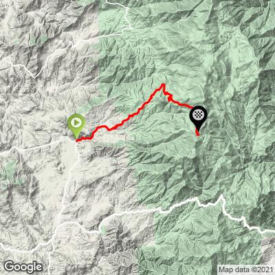
Ride 13.6 miles gaining 4,264’ at 5.7% average grade.
![]()
#61 on the Top 100 list, Portguguese Pass is one of 3 Top 100 climbs in the southwestern Sierra Nevada Mountain Range within 50 miles of the each other - Sherman Pass West (#12, 50 miles northeast) and Shirley Meadows (#26, 26 miles southeast).
![]()
Strava member Thomas Morgan, Bakersfield provides an excellent summary of this climb:
Depending on the season and your ambition, Portuguese Pass can be approached from a variety of starting points. If you start from Bakersfield the round trip is over 120 miles with 11,000 feet of climbing. From metro Bakersfield, you head north on Granite Road, which the Strava map also shows as Bakersfield-Glennville Road. your first choice for alternate starting points comes at what locals refer to as the Woody Y. The Woody Y is at the intersection of Granite Road, Woody Road and Famoso Road. Both Woody and Granite lead north to the small community of Glennville. The Woody Y is about 20 miles north of Downtown Bakersfield. Glennville is about 20 miles north of the Woody Y and about 40 miles north of Bakersfield. Once you get to the very small community of Woody, Woody Road intersects with Hwy 155. You head north on 155 to Glennville. There are two places that you get water in Woody, including the Community Center and the Post Office. There is also a County fire station that likely would have water, but we've never checked. Woody is also a popular starting point, especially when it starts to heat up in the valley. Once you get to Glennville you will find the small cyclist friendly Glennville Market that is great for restocking and hydrating. In the summer, Glennville is also a great starting point for the ride up to Portuguese Pass, not to mention the climb to Alta Sierra to the east on 155. From Bakersfield to Glennville you gain about 4000 feet.
From Glennville head north about a quarter to a half mile to the intersection of 155 and Jack Ranch Road. From the start of Jack Ranch to the intersection of Jack Ranch and Old Stage Road the pavement is good and the scenery is beautiful through easy rolling hills. After Jack Ranch passes Old stage the climbing begins again. A couple of miles after you start climbing, you enter the community of Posey, which has only a post office and a few homes. The Strava map labels the road north of Old Stage as M-3, but my recollection is that the signage is still Jack Ranch. About 2 miles past Posey, turn left on Sugarloaf Drive and just keep going up. While it’s a little unclear on the map, as to the road designation to the top, if you don't take any turns off of what appears to be the main roadway, you shouldn't have any problems reaching the pass. From the turn onto Sugarloaf the next 'community' is Sugarloaf, which is mostly summer cabins, a volunteer fire station, and the abandoned Sugarloaf Lodge. The land past the old lodge is Forest Service and there are no more homes or services, until about a half mile short of the summit. At this point on the climb up, off to the left, and very easy to miss is a small PVC pipe that provides cold spring water, or at least it did the last time I was there. It was running so slow, I'm sure due to our drought, that it took me about 10 minutes to fill my bottles, but I wasn't complaining. Most of the climb on Sugarloaf is in an evergreen forest and the area above the lodge is breathtaking. From Bakersfield, the pass is about 60 miles and according to Garmin it tops out around 7000 feet above sea level.
Thanks much Tom!
We rode this Pass in July, 2015 and add to Tom’s summary as follows:
- We enter Sequoia National Forest around mile 5.
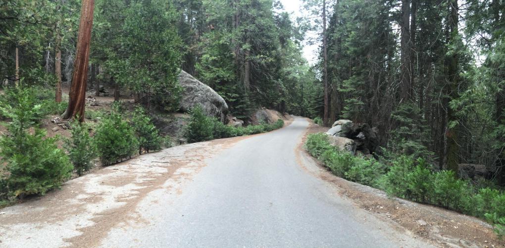
- The landscape is grassland, oaks and brush (e.g. manzanita, chaparral, etc.) along the lower levels, and slowly turning into urning to oak, scrub brush, manzanita etc. an alpine setting and forested area from mile 9 on.
- We pass through 3 small communities along the way (no provisions to be had) - Posey at around mile 1.5, Sugarloaf around mile 6 and Guernsey Mill at mile 8.5 (these are really just an accumulation of a few houses which is a big deal in those parts because it is a very remote area!).
- The road averages just under 1% from around miles 6 to 8 (you know what that means - the other miles are more than 5.7%!)
- Roadway/Traffic: minimal traffic, but very dicey descent as the roadway is (like most Top 100’s) reasonably steep and this one has sharp turns, and in spots can be sandy and/or debris in spots. There is no civilization for the last 5 miles so study your map and turns well before embarking on this adventure (either write down the fork/turn points, bring a que sheet (they can be printed from the RideWithGPS link below, or download the route to your GPS using the RideWithGPS linke for this climb).