Sandia Crest Bike Climb - PJAMM Cycling

8.3
FIETS
13.5 mi
DISTANCE
3,892 ft
GAINED
5.3 %
AVG. GRADE

FULL CLIMB STATS

INTRO

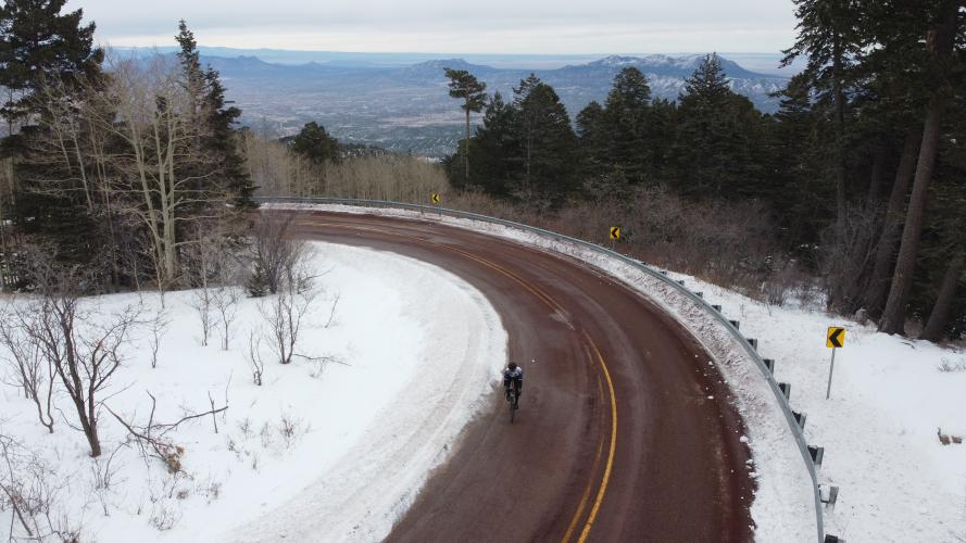
"Sandia Crest near Albuquerque is a solid climb up to high altitude and great views and may be the most difficult ascent in scenic New Mexico. After a straight and fairly shallow start to the west, you will soon pass a few houses tucked into the trees. The road eventually enters a mostly pine forest and begins to twist up the hill through multiple switchbacks and over solid grade. There is a small descent just before you pass a ski area on the left and then climbing soon continues. From this point multiple consecutive switchbacks take you the rest of the way up the mountain over solid and mostly steady grade. In places there are two lane sections uphill for a bit more room although traffic should rarely be an issue..." (Quoted with the approval of John Summerson, from The Complete Guide to Climbing (by Bike), 2nd Edition, pg. 201.)
Average grade is 5.3% (5.9% climb only).  30% of the climb is at 0-5% grade and 60% is at 5-10%.  The steepest quarter-mile is 9.1% and steepest continuous mile 6.9%.  Only 3% of the climb is at ≥10% grade.

See more details and tools regarding this climb's grade via the “Profile Tool” button.
Roadway:  The Sandia Crest Scenic Byway is in excellent condition and open during the winter, weather permitting.  Check the weather and roadway conditions here: nmroads.com, or at the Sandia Park Traffic and Road Conditions site

Traffic:  This is an out and back with mild to moderate traffic, particularly higher up the mountain. 

Parking:  In addition to locations near the start of the climb (e.g. just off Highway 536 on the side of the road on Meadowlark Lane just east of climb start) you may consider parking at the US Post Office just on the east side of Highway 14 a few blocks east of our start point: Map; Street View
Weather and Clothing:  Conditions nearly 6,000' above your starting altitude may be dramatically different than at the start - Consult the PJAMM "Full Forecast" feature for the time you expect to arrive at the finish to assess what clothing to bring on your ride.   Be prepared to have very warm clothing - on our two trips up Sandia Crest, one in September and one in November, it was extremely cold at the top. 

Food/Drink:  There is the Two Mile High Cafe at the top. 


Before heading out on any cycling adventure check out our Things to Bring on a Cycling Trip and use our interactive check list to ensure you don't forget anything.
Be sure to spend time at the Sandia Crest House (Google Map + Reviews) at Sandia Crest Summit and also consider the Tinkertown Museum on the left 1.3 miles up the climb from the start (Google Map + Reviews). 

You can stay in nearby Albuquerque where there are many great options for hotels and unique vacation rental experiences.
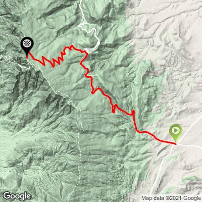
ROUTE MAP

MEMBER RATING

Difficulty: Challenging
4.3
Road
3.7
Traffic
4
Scenery

CURRENT WEATHER

PJAMM TRIPS ADVENTURE STARTER BUNDLES

Check out PJAMM Adventure's prepackaged (self-guided) cycling trips. They will help you plan, document and conquer your next adventure.
ALL TRIPS
Browse all of our prepackaged trips and find your next adventure!
The American Southwest
United States (AZ,NM,UT)
18 ROUTES
27 POIs
ROUTE STATS (TOTAL)
215.4
mi
DISTANCE
34,866
ft
ELEV. GAIN

NEARBY CLIMBS (0) RADIAL PROXIMITY

FROM
No Climbs Found

MEMBER REVIEWS & COMMENTS

Let us know what you thought of this climb. Signup for our FREE membership to write a review or post a comment.
Already have an account?

Sep 17, 2023
difficulty: Challenging
scenery: 3
traffic: 2
road: 5
Sep 17, 2023
scenery: 3
traffic: 2
road: 5
Sept 17, 2023 A nice climb on a good road with wide shoulders. Wonderful switchbacks. I rode on a Sunday so traffic was steady with some knuckleheads in cars and motorcycles screaming their way up and down. The road was wide so I felt safe. I took John's advice (pjamm) and departed Turquoise Trail Campground and went down hwy 14 to route 66 to N. Zamora rd then up Gutierrez Canyon Rd (25mph speed limit) then up Frost rd (306) then up Sandia Crest Rd (536). This adds 13 miles and about 1000ft of climbing. No water and cold on top.
Jun 4, 2021
difficulty: Challenging
scenery: 5
traffic: 4
road: 4
Jun 4, 2021
scenery: 5
traffic: 4
road: 4
I’ve ridden this climb a dozen time or more while I lived in Albuquerque. No too long or steep. The challenge is altitude. I’ve done this ride in December and the middle of summer. I got hypothermia descending it in the winter. I got pretty sweaty climbing it, and froze almost to death coming down. Dress accordingly. The switchbacks at the top are splendid. I also raced this once, starting in Albuquerque. Lots of great food stops on the East mountain....
Mar 26, 2021
difficulty: Challenging
scenery: 4
traffic: 5
road: 4
Mar 26, 2021
scenery: 4
traffic: 5
road: 4
I biked this on Christmas day in 2019. It was amazing! Unfortunately, my Garmin failed and I lost all of my data. It was an unusually warm day and had been a very mild winter thus far, so there wasn't much snow, nor was there much traffic. Also the ski resort up that road wasn't open, so maybe that's why there was no traffic. It's a great climb but never too intense. The views at the top are awesome.
ROUTE MAP
PROFILE TOOL
Route Data
S.G. (%)
hide
Segment Data
hide

Climb Profile Not Found
CLIMB SUMMARY

Cycling Sandia Crest

Ride 13.5 miles gaining 3,912’ at 5.3% average grade

Sandia Crest, view from the top.

Climb summary by PJAMM’s John Johnson.

The Sandia Crest bike climb is on the Sandia Crest Scenic Byway (Highway 536) near Albuquerque, New Mexico, and is #68 on the US Top 100 list.  The climb is not a high Top 100 concentration area --   #91 Highway 82, NM is 196 miles south and #79 Wolf Creek Pass, CO is 206 miles north.  This makes Sandia Crest a destination climb. However, if one is willing to ride on a bit of gravel and overlap 6 of the last five miles, Sandia Crest Backside is a nice climb and the hardest in New Mexico.

This climb takes the rider to the highest point in the Sandia Mountains, Sandia Crest. There is an excellent summary of this ride by the New Mexico Touring Society at Sandia Crest Climb, reporting a 42 and 56 mile ride which includes this climb in its description.

There is a nice gift shop and cafe at the top of the climb along with an information center.

The Sandia Crest climb enters Cibola National Forest at mile 1.2 and rides into the Sandia Mountains:

“Just east of Albuquerque, the Sandia Mountains are the most visited mountains in New Mexico. Millions of people journey into the Sandia Mountains each year. More than half these visitors ride the Sandia Peak Tram or drive the Sandia Crest National Scenic Byway to take in spectacular panoramic views of Central New Mexico and to enjoy many other recreational opportunities. The Sandia Crest Scenic Byway 536, has several picnic sites with shelters and group areas for reservation.”  National Forest Service - Sandia Mountains

Climbing Sandia Crest by bike - Cibola National Forest sign.

Enter the National Forest at mile 1.2.

The climb begins in San Antonio, New Mexico which is roughly in the middle of the state on the Rio Grande River.  From San Antonio we ride west into the Sandia Mountains, the most visited mountains in New Mexico.  

Be sure to visit the Tinkertown Museum 1.2 miles from the start - you could also consider starting your climb from the museum parking lot and visiting the museum before or after your climb.  This is a very special place!

Photo:  Tinkertown.com

Tinkertown:

“It took Ross Ward over 40 years to carve, collect, and lovingly construct what is now Tinkertown Museum. His miniature wood-carved figures were first part of a traveling exhibit, driven to county fairs and carnivals in the 1960s and ’70s. Today over 50,000 glass bottles form rambling walls that surround a 22-room museum. Wagon wheels, old fashioned store fronts, and wacky western memorabilia make Tinkertown’s exterior as much as a museum as the wonders within.”  More

Tinkertown 

Photos by Kasia Halka

See Kasia’s exceptional flickr portfolio

Thank you kasia 👍 📷👍

Sandia Crest:

“The Sandia Mountains are a small range east of Albuquerque, New Mexico. The mountains do not have a summit. Instead, the high point is a long ridge called the Sandia Crest. At 10,678 feet in elevation, the vegetation here is vastly different than in Albuquerque that lies about 4,500 feet below. Access to the Sandia Crest is easy and this is a popular tourist destination. The best wildflower viewing is along a hiking trail that starts at the southwestern corner of the parking lot. The trail is paved for a short distance for handicapped access and then becomes packed dirt. It is relatively level and easy to walk. The trail follows the limestone outcrops along the crest and then heads into the forest so you have an opportunity to see both sun-loving and shade-loving plants.” National Forest Service - Sandia Crest

Views from the Top

When to Cycle Sandia Crest:

The road is open, weather permitting, year round.  You’ll be traveling to high altitude so it is recommended this climb be done between May and September.


How to Climb Sandia Crest by Bike:

No special gearing or gear is needed for this climb.  The grade throughout is mild and averages a reasonable 5.3% (steepest ½ mile is 7.8%).  The road is paved from top to bottom and the weather is generally mild, although do bring at least a wind jacket with you since you will top out above 10,000’ at the Information Center.  The climb itself begins at the intersection of Highway 14 and Sandia Crest Rd, Sandia Park, NM, 26 miles northeast of Albuquerque International Airport (Latitude: 35.16311Longitude: -106.34845).

PJAMM contributor Kip Taylor of Boulder, CO (and Sandia Crest KOM) provides an exceptional summary of this climb:

The Sandia Crest is a must do! If you are a resident and cyclist in Albuquerque you can see the Crest anywhere you go. It almost calls out to you to come and challenge it. Because of this it is the local climb of choice. It attracts riders of all abilities making for a fun group ride or hard day on the saddle... The higher elevation and thick forest also makes this ride a cool retreat in the hot summer months and provides nice protection from the wind on gusty days... For a shorter ride you can start at what locals call the "Triangle" which is right at the bottom of the climb... Start the Climb from ABQ and you can easily make it a 80-100 mile day on the bike... Local tip, to make this ride extra beautiful instead of taking Highway 14 which goes directly to the base of the climb, go just a bit further northeast to Gutierrez Canyon which takes you North to Frost Road.  Left on Frost Road will take you directly to the Crest Climb... The Crest also plays host to the annual Bill McLain Memorial - Sandia Crest Road Race, in memory of Bill who was very well known and loved in the ABQ community.  The Climb itself can be broken down into a few segments... the first half is very consistent and has some long stretches with a fairly constant grade of ~5-6%... When you get to the Sandia Peak Ski Resort base the road flattens out long enough to catch your breath... The last half of the climb is definitely the hardest as you find yourself getting over 10,000 feet and hitting steep switchbacks... the grade is also less predictable and shoots up to areas of 11-12%... the last sweeping left turn turn to the home stretch calms down to about a 3-4% grade which is just enough to finish the climb really strong... Once you get to the top you are joined by tourists, hikers and Sandia Tram riders (the Sandia Tram is known for being the longest in the world!) who love to ask questions about riding a bike to the top of this mountain! ***One final note to add... The Crest Road is being re-paved from bottom to top... this makes for great contact on your tires going up, and allows any rider a speedy and confident descent!