Kancamagus Pass East Bike Climb - PJAMM Cycling

2.3
FIETS
5.3 mi
DISTANCE
1,466 ft
GAINED
5.3 %
AVG. GRADE

FULL CLIMB STATS

INTRO

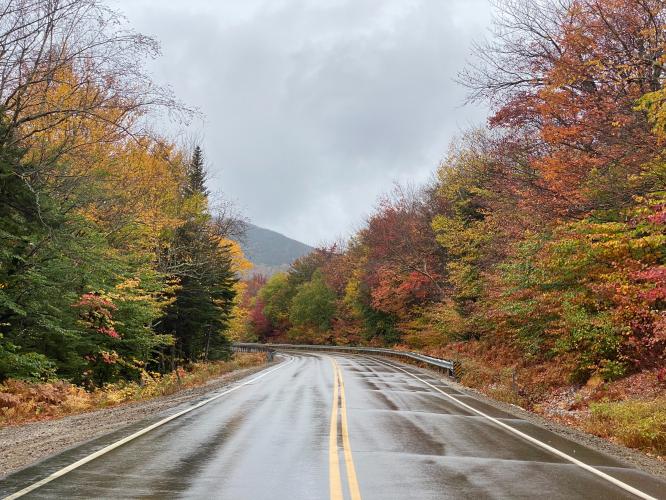
This 5.3 mile bike climb is located in NH, USA. The average gradient is 5.3% and there is a total elevation gain of 1,466 ft, finishing at 2,744 ft.

Use the profile tool, route map, and weather forecast to conquer this cycling climb.
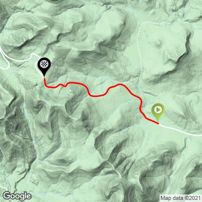
See more details and tools regarding this climb's grade via our interactive Profile Tool.
Information Not Available

If you have any information regarding this climb, we'd like to hear from you. Click the CONTRIBUTE button to share your thoughts with us.

Information Not Available

If you have any information regarding this climb, we'd like to hear from you. Click the CONTRIBUTE button to share your thoughts with us.

Before heading out on any cycling adventure check out our Things to Bring on a Cycling Trip and use our interactive check list to ensure you don't forget anything.
Information Not Available

If you have any information regarding this climb, we'd like to hear from you. Click the CONTRIBUTE button to share your thoughts with us.

ROUTE MAP

MEMBER RATING

Not Yet Rated
-
Road
-
Traffic
-
Scenery

CURRENT WEATHER

PJAMM TRIPS ADVENTURE STARTER BUNDLES

Check out PJAMM Adventure's prepackaged (self-guided) cycling trips. They will help you plan, document and conquer your next adventure.
ALL TRIPS
Browse all of our prepackaged trips and find your next adventure!
Mt. Washington Auto Road Race
United States (MA,ME,NH,VT)
3 ROUTES
23 POIs
ROUTE STATS (TOTAL)
7.4
mi
DISTANCE
4,678
ft
ELEV. GAIN
Northeast Fall Colors
United States (MA,ME,NH,NY,VT)
24 ROUTES
37 POIs
ROUTE STATS (TOTAL)
98
mi
DISTANCE
35,116
ft
ELEV. GAIN

NEARBY CLIMBS (0) RADIAL PROXIMITY

FROM
No Climbs Found

MEMBER REVIEWS & COMMENTS

Let us know what you thought of this climb. Signup for our FREE membership to write a review or post a comment.
Already have an account?
ROUTE MAP
PROFILE TOOL
Route Data
S.G. (%)
hide
Segment Data
hide

Climb Profile Not Found
CLIMB SUMMARY

Cycling Kancamagus East (Conway), New Hampshire - wet two-lane road surrounded by very dense yellow, orange, and red fall foliage

Cycling Kancamagus Pass East, New Hampshire

Ride 5.3 miles gaining 1,463’ at 5.2% average grade.

“One of the most scenic climbs in this guide, the east side of Kancamagus Pass is a steady grade ascent through woods and with views in places.  It is also one of the most popular in the Northeast.  It begins as you ride west over moderate grade which eases as you approach a bridge about 0.5 miles in.  Just beyond the bridge moderate grade returns as the road flows through graceful turns.  The last 1.5 miles are just a bit steeper and then the grade eases as you approach the finish at the signed summit.”  (This quote is provided with the approval of John Summerson from his book, The Complete Guide to Climbing (By Bike) in the Northeast, pg. 98.)

Cycling Kancamagus East (Conway), New Hampshire - photo collage, sign for Sugar Hill Scenic Vista, sign for White Mountain National Forest, large boulders in creek bed, fall foliage, PJAMM Cycling logo in corner

This is a climb on moderately busy Route 112 which connects Conway and Lincoln, New Hampshire.  This side of the climb has more scenic overlooks than the western approach from Lincoln and is quite beautiful, particularly during the fall.  You can bomb up this one with a consistent grade of 5-7% (steepest quarter-mile 7.1%, and steepest mile 6.6%).

Cycling Kancamagus East (Conway), New Hampshire - visitors center at White Mountain, inside and outside view

White Mountains Visitor Center, Lincoln, New Hampshire

Visit our White Mountains Fall Colors Climb Page

Kancamagus Pass is in the White Mountains of New Hampshire, an extremely popular recreation area both during the summer and winter months.  The White Mountains cover roughly a quarter of New Hampshire and have many great cycling climbs within its boundary.

We stayed in Lincoln for our White Mountains climb.  Lincoln is a bustling yet charming all seasons hub for the White Mountains.

Cycling Kancamagus East (Conway), New Hampshire - Lower Falls Recreation Site, large boulders in creek bed, fall foliage, PJAMM Cycling logo

Lower Falls Recreation Site is located between Conway and the start of the climb.

Kancamagus was the final chief of the Pennacook tribe which inhabited this area in the 17th century.  Kancamagus means “Fearless One.”

Cycling Kancamagus East (Conway), New Hampshire - Sugar Hill Scenic vista, fall foliage

Sugar Hill Scenic Vista -- within the first mile of the start.

Between the scenic overlooks the roadway is bordered by thick forest. Route 112 is popular for its fall foliage.  The scenic byway has its own website, here.

“The Kancamagus Highway is a 34.5 mile scenic drive along NH's Rt. 112 in Northern New Hampshire that is well known as one of the best Fall Foliage viewing areas in the country. The Kancamagus Highway is now designated an American Scenic Byway for its rich history, aesthetic beauty and culture.

The Kancamagus Scenic Byway takes you through a path cut through the White Mountain National Forest with breathtaking views of the White Mountains, the Swift River, Sabbaday Falls, Lower Falls and Rocky Gorge. The Kanc takes you to an elevation of just under 3,000 feet at its highest point at Kancamagus Pass on the flank of Mt. Kancamagus near Lincoln, NH” (read more here).

Cycling Kancamagus East (Conway), New Hampshire - photo collage, C.L. Graham Scenic Overlook, informational signs, fall foliage, PJAMM Cycling logo

C.L. Graham Scenic Overlook just before the pass at the top of the climb.

Traffic and Roadway Conditions:  Highway traffic is moderate along the climb.  There is often no bike lane or shoulder so cyclists that are traffic averse should give this one a second thought. The roadway was in excellent condition as of September, 2020.