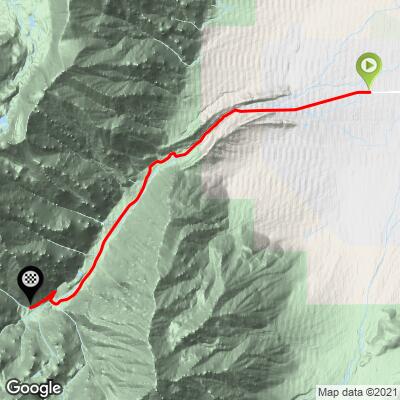
Pine Creek Bike Climb - PJAMM Cycling

8.3
FIETS
8.8 mi
DISTANCE
3,241 ft
GAINED
7 %
AVG. GRADE

FULL CLIMB STATS

Page Contributor(s): Ron Hawks, Las Vegas, Nevada, USA

INTRO

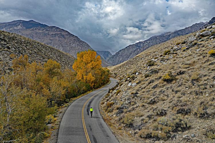
Ranked #79 in the US, Pine Creek Road is one of our favorite climbs in California and the US. The first two miles are in high desert-like conditions, but at about three miles we enter a true canyon that surrounds us for the remainder of the climb. This is a slot canyon which dead-ends at a gate that can be passed by bike, with the climb finishing at a long-abandoned (but maintained for potential future use) Pine Creek Tungsten Mine. By mile six we are passing some very distinct rock formations, but on our trip up the canyon we fought brutal westerly winds which is common throughout the Owens Valley. At seven miles we pass through a stretch with more trees, nearing the end of this slot canyon.
Climb 8.8 miles gaining 3,195' at 6.9% average grade.  19% of the climb is at 0-5% grade, 70% is at 5-10%, and the remaining 11% is at 10-15% grade.  The steepest quarter-mile is 11.2% and steepest mile 9.9%.

See more details and tools regarding this climb's grade via the “Profile Tool” button.
Roadway:  Two lane paved road with center stripe in good condition.  For road conditions see Inyo County Road Open/Closed Status.

Traffic:  Minimal.

Parking:  At climb start (Map;  Street View not available), or ride from Bishop if you are staying there 12 miles east (Map). 

Note: Check weather conditions with the Inyo National Forest Service for each climb you intend to do and the Inyo County road conditions website before traveling to Owens Valley to cycle anytime after September or before June. 
Provisions:  This is an isolated climb - there is no water or food on this route. 
Before heading out on any cycling adventure check out our Things to Bring on a Cycling Trip and use our interactive check list to ensure you don't forget anything.
We prefer to stay in Bishop which is only 12 miles from the start of the climb and a hub for cycling in Owens Valley (see PJAMM Owen's Valley, CA climb area page).  

ROUTE MAP

MEMBER RATING

Difficulty: Challenging
3.5
Road
4.5
Traffic
5
Scenery

CURRENT WEATHER

PJAMM TRIPS ADVENTURE STARTER BUNDLES

Check out PJAMM Adventure's prepackaged (self-guided) cycling trips. They will help you plan, document and conquer your next adventure.
ALL TRIPS
Browse all of our prepackaged trips and find your next adventure!
Owens Valley: Bishop
United States (CA)
19 ROUTES
26 POIs
ROUTE STATS (TOTAL)
268.3
mi
DISTANCE
55,531
ft
ELEV. GAIN
Owens Valley: Lone Pine
United States (CA)
15 ROUTES
31 POIs
ROUTE STATS (TOTAL)
157.7
mi
DISTANCE
51,016
ft
ELEV. GAIN

NEARBY CLIMBS (0) RADIAL PROXIMITY

FROM
No Climbs Found

MEMBER REVIEWS & COMMENTS

Let us know what you thought of this climb. Signup for our FREE membership to write a review or post a comment.
Already have an account?

Sep 11, 2023
difficulty: Moderate
scenery: 5
traffic: 5
road: 4
Sep 11, 2023
scenery: 5
traffic: 5
road: 4
Sept 10, 2023 This is a nice, moderately easy, "rest day" climb to do between the big 4 climbs. Only "steep" section occurs after the gate on a very rough but short road to the mine area. Large parking area at the start of Pine Creek Rd off 395. A very good road up until the last mile (not including the very bad road after the gate) then some cracks across the road. A fantastic, no brakes, bomb back down to 395. No shoulder on the road but very light traffic.
Jun 12, 2021
difficulty: Challenging
scenery: 5
traffic: 4
road: 3
Jun 12, 2021
scenery: 5
traffic: 4
road: 3
Pine Creek is a solid cat 1 climb that doesn't see a lot of riders. Easy start soon gets solid as the road begins to twist a bit. 2/3rds of the way up a flat stretch lets you catch your breath with big mtns in front of you. With a mile to go, go around the gate to catch double digit grade up to the dead end.
ROUTE MAP
PROFILE TOOL
Route Data
S.G. (%)
hide
Segment Data
hide

Climb Profile Not Found
CLIMB SUMMARY

Cycling Pine Creek Road, California - PJAMM Cyclist rides on two-lane highway road in high desert setting, mountains in front of her

Cycling the remote (and a bit eerie) Pine Creek Road, California.

Ride 8.8 miles gaining 3,260’ to elevation 7,880 at 7% average grade. 

Cycling Pine Creek Road, California -  photo collage, PJAMM Cycling logo in corner, bike parked in front of No Trespassing sign, aerial drone view of roadway, aerial drone view of cyclist on two-lane roadway, two-lane highway roadway in desert setting going toward mountains, cyclist rides on roadway beyond closed gate

Pine Creek Road is one of our favorite climbs in California and the US.  The first two miles are in high desert-like conditions, but at about three miles we enter a true canyon that surrounds us for the remainder of the climb.  This is a slot canyon which deadends at a gate that can be passed by bike, with the climb finishing at a long-abandoned (but maintained for potential future use) Pine Creek Tungsten Mine.  By mile six we are passing some very distinct rock formations, but on our trip up the canyon we fought brutal westerly winds which is common throughout the Owens Valley. At seven miles we pass through a stretch with more trees, nearing the end of this slot canyon.

Cycling Pine Creek Road, California - aerial drone view of roadway surrounded by high rock walls

SCENIC APPROACH TO THE BEGINNING OF THE CLIMB

This extraordinary bike climb is easily accessible from Bishop and can be done in combination with the Rock Creek Road climb.  The Pine Creek Road climb begins about 12 miles northeast of Bishop and just a couple miles from the start of the Rock Creek Road climb.  The Pine Creek + Rock Creek one-two punch is 94 miles gaining 10,220’ of elevation.

Clip #1:  Iconic abandoned farmhouse on Pine Creek Road a mile east of the start.

#2:  Pine Creek Road just west of its intersection with Old Sherwin Grade Road (aka Lower Rock Creek Road).

Cycling Pine Creek Road, California - views 1-2 miles before start of climb, mountains in distance, old farmhouse, two-lane roadway lined with trees

1-2 miles before the start.

Cycling Pine Creek Road, California - views on the first few miles of the climb, sign for Pine Creek Village, bike laying on center divider of two-lane roadway, bike parked in front of street sign with mountains beyond

First few miles of the climb

Cycling Pine Creek Road, California - drone photo shows straight, two-lane roadway headed east two miles from start of climb

Photo looking east about two miles from the start.

While the approach to the climb, as well as its first three miles, are through typical wide open Owens Valley surroundings

(as seen below), the prairie quickly gives way...

Cycling Pine Creek Road, California - aerial drone views on final two-thirds of climb, narrow canyon surrounded by high rock walls

...to a very steep and narrow canyon the final two-thirds of the climb.

Aerial view west towards the end of the road.  

   Bicycling Pine Creek Road , Owens Valley - abandoned mine at end of road

Climb ends in a slot canyon at an abandoned mine.

US #81 Pine Creek Road is one of the nine Top 100 most difficult climbs in the U.S that begins in the Owens Valley, on the eastern side of the Sierra Nevada mountain range in the central/eastern portion of California.  Visit our PJAMM Owens Valley Climb Page for more information on rides in the area.

Our Caveat:  At mile 7.85 we are greeted by a closed swinging yellow gate with three signs:  a stop sign, another sign (below) "Pine Creek Mine, Avocet Tungsten, LLC Do Not Block Gate,” and a sign that says "Authorized Vehicles Only - hiking access to Morgan Pass Only - Not for Pine Lakes."  So, the sign doesn't specifically say "no trespassing" and suggests use of the road is authorized, at least for hiking.  We have done this climb twice and, although we encountered no cyclists on our trip up the canyon and saw no sign of life either time at the mine, it appears acceptable to go the extra mile (well, 0.8 mile) to the true finish of this one.

Cycling Pine Creek Road, California - signs at trailhead parking lot, 0.8 miles from true finish of climb

Pine Creek Pass Trailhead Parking Lot and end of the line -- for cars!

Several hiking trails stage here. The area is surrounded by 13,000’ peaks.

Cycling Pine Creek Road, California - an abandoned tungsten mine about 0.8 miles from climb finish

0.8 miles at 10.5% to the finish.

Cycling Pine Creek Road, California - aerial drone views from abandoned tungsten mine at end of climb

Cycling Pine Creek Road , Owens Valley - sign and gate at end of road

Fun descent on a decent road.

An extremely insightful and entertaining blog post for Pine Creek is found at geotripper.blogspot.com:

“Imagine a canyon one or two thousand feet deeper than the Grand Canyon, twice as deep as Yosemite Valley, a glacially carved trough surrounded by dramatic mountain peaks reaching almost 14,000 feet into the sky. A canyon filled with remarkable exposures of granitic and metamorphic rocks that serve as a microcosm of the geology of the entire Sierra Nevada. Such a canyon would be Pine Creek, on the eastern side of the Sierra Nevada a few miles northwest of the town of Bishop. It's a spectacular place to visit and appreciate geology. . . .

The Pine Creek Tungsten Mine was an extraordinary operation. Begun in 1918, the mine operated until 2001, producing (along with the Climax mine in Colorado) 93% of the tungsten produced in the United States as of 1977. Low cost imports led to the mothballing of the mine in 2001 although the operation remains in place should prices rise, or strategic concerns cause an increase in demand for domestic sources of tungsten (China provides most of our tungsten at this time).”  More

You will get a very good sense of the climb viewing our YouTube videos.

Roadway Surface and Traffic Report: The road is lightly traveled and in good condition except for the final 0.8 miles from the yellow gate to the tungsten mine which is pretty rough.

That’s a wrap!

Access to full Climb Summary requires a PJAMM Cycling PRO Membership!

It takes less than a minute to sign up & with your PRO membership you can:
  • Rate climbs, post comments and share your experiences on any of our climb pages
  • Create bucket lists of climbs & mark the dates you complete them
  • Weather data for all climbs - Start & Finish
  • Upload photos to your member page to customize your PJAMM Cycling experience
  • Utilize all of our interactive tools - Profile & Routes in Area
  • Download climb route .gpx files
LEARN MORE
SIGN UP

Already have an account? LOG IN HERE