Route 118 South Bike Climb - PJAMM Cycling

7.3
PDI
4 mi
DISTANCE
1,295 ft
GAINED
6.2 %
AVG. GRADE

FULL CLIMB STATS

Page Contributor(s): John Summerson, The Complete Guide to Climbing (By Bike), 2nd Edition

INTRO

This 4 mile bike climb is located in NH, USA. The average gradient is 6.2% and there is a total elevation gain of 1,295 ft, finishing at 2,505 ft.

Use the profile tool, route map, and weather forecast to conquer this cycling climb.

PLAN YOUR ROUTE

We've partnered with Sherpa-Map.com to bring you the best route planning tool. With a PRO Membership you can use this climb as a reference when creating your route.

See more details and tools regarding this climb's grade via our interactive Profile Tool.
Information Not Available

If you have any information regarding this climb, we'd like to hear from you. Click the CONTRIBUTE button to share your thoughts with us.

Information Not Available

If you have any information regarding this climb, we'd like to hear from you. Click the CONTRIBUTE button to share your thoughts with us.

Before heading out on any cycling adventure check out our Things to Bring on a Cycling Trip and use our interactive check list to ensure you don't forget anything.
Information Not Available

If you have any information regarding this climb, we'd like to hear from you. Click the CONTRIBUTE button to share your thoughts with us.

ROUTE MAP

MEMBER RATING

Difficulty: Strenuous
3
Road
5
Traffic
4
Scenery

CURRENT WEATHER

PJAMM TRIPS ADVENTURE STARTER BUNDLES

Check out PJAMM Adventure's prepackaged (self-guided) cycling trips. They will help you plan, document and conquer your next adventure.
ALL TRIPS
Browse all of our prepackaged trips and find your next adventure!
Mt. Washington Auto Road Race
United States (MA,ME,NH,VT)
3 ROUTES
23 POIs
ROUTE STATS (TOTAL)
7.4
mi
DISTANCE
4,678
ft
ELEV. GAIN
Northeast Fall Colors
United States (MA,ME,NH,NY,VT)
24 ROUTES
37 POIs
ROUTE STATS (TOTAL)
98
mi
DISTANCE
35,116
ft
ELEV. GAIN

NEARBY CLIMBS (0) RADIAL PROXIMITY

FROM
No Climbs Found

MEMBER REVIEWS & COMMENTS

Let us know what you thought of this climb. Signup for our FREE membership to write a review or post a comment.
Already have an account?

Feb 7, 2022
difficulty: Strenuous
scenery: 4
traffic: 5
road: 3
Feb 7, 2022
scenery: 4
traffic: 5
road: 3
I've done this climb a number of times. One of my favorites! Very few cars and very low stress - I've climbed the whole thing without a car passing me before. Road will have some ice heaves in the pavement, mostly towards the bottom. A few lookout points, but not exactly a road with those stunning views - that's why there are fewer people on it in peak seasons, but you'll find lupine growing, salamanders sunbathing, and piece and quiet among the trees. Start anywhere in Warren, NH. This makes for a great morning or afternoon! And it can easily be scaled up to make a longer ride: you can add the backside to Woodstock or you can go all the way up the Kancamagus Climb for an epic ride.
ROUTE MAP
PROFILE TOOL
Route Data
S.G. (%)
hide
Segment Data
hide
CLIMB SUMMARY

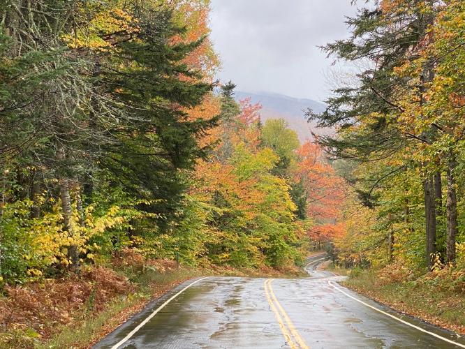
Cycling Route 118 South, New Hampshire - wet, two-lane road surrounded by fall foliage and mist

Cycling New Hampshire Route 118 South

Ride 4 miles gaining 1,300’ at 6.2% average grade.

This nice climb begins near Warren, New Hampshire (pop. 904; est. 1763). The climb has some challenging segments, with one mile averaging a tough 9%.

“The south side of 118 is a bit shorter and steeper overall but similar to its north side.  The road on which you ride carries little traffic much of the time.  It begins over shallow grade which goes up and down early on and you pass a few houses along the semi wooded road.  The slope gradually increases so that the middle of the climb contains the most challenging peddling on the mountain.  As you approach the top the grade eases just a bit overall and the climb ends at an unmarked summit within thick cover.” (This quote provided with the approval of John Summerson from his book, The Complete Guide to Climbing (by Bike) in the Northeast, pg. 102.)

Cycling Route 118 South, New Hampshire  - photo collage, sign for White Mountain National Forest, fall foliage, Redstone Ballistic missle, PJAMM Cycling logo in corner

Extremely popular area during fall colors . . . and rightly so!

The town's most famous landmark is a Redstone ballistic missile erected in the center of the village green. It was donated by Henry T. Asselin, who transported the missile from the Redstone Arsenal near Huntsville, Alabama, in 1971, and placed it in honor of long-time Senator Norris Cotton, a Warren native.

Cycling Route 118 South, New Hampshire  - bike parked in front of Redstone ballistic missle

Cycling Route 118 South, New Hampshire  - signed photo of and informational sign about Redstone Ballistic missle

Cycling Route 118 South, New Hampshire - informational sign on Redstone Ballistic Missle

Cycling Route 118 South, New Hampshire  - PJAMM Adventure App shows climb grade and profile

PJAMM Adventure App showing climb gradient.

As with most climbs in the White Mountains, we are surrounded by trees most of the climb -- not a problem during leaf peeping season!  From the summit, we descend the north side of Route 118 into the charming tourist town of Lincoln, where the White Mountain National Forest Visitor Center is located.

Cycling Route 118 South, New Hampshire  - White Mountains visitors center

White Mountains Visitor Center, Lincoln, New Hampshire.

Visit our White Mountains Fall Colors Climb Page.