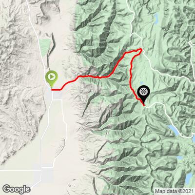
23.6
PDI
13.4 mi
DISTANCE
3,912 ft
GAINED
5.4 %
AVG. GRADE
FULL CLIMB STATS
Page Contributor(s): Ron Hawks, Las Vegas, Nevada, USA; Bruce Hamilton, La Quinta, CA, USA; Stacy Topping, Tacoma, WA, USA.
INTRO
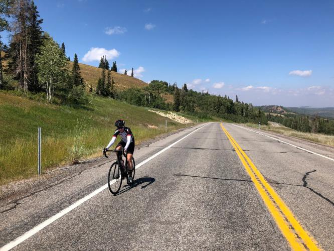
This #75 US Top 100 bike climb is situated in the center of Utah, 95 miles due south of Salt Lake City and 215 miles north of Zion National Park. The views are good (canyon and forest) after the first couple of miles. We were limited in our observations of distant vistas due to rain when we made this climb on August 4, 2014. The crux of the climb is from miles 2-6.5 (1,875' at 7.9% average grade).
"Route 31 is an interesting and difficult climb up into the high country of central Utah on a road that sees little traffic most of the time. There is fairly stout grade over the first 2/3rd of the hill as the road heads up the ridge through multiple turns. Towards the top the slope eases up to its unmarked top..." (This quote is presented with the approval of John Summerson from his book, 50 Climbs (by Bike) in Utah, pg. 126.)
PLAN YOUR ROUTE
5.3% average grade (6% with descent eliminated) - 33% of the climb is at 0-5% and 54% is at 5-10%. The steepest quarter-mile is 9.8% and steepest mile 8.5%.
See more details and tools regarding this climb's grade via the “Profile Tool” button.
Roadway: Two lane highway in good condition with a narrow shoulder for part of the climb and no shoulder for much of the climb.
Traffic: Light.
Parking: Near the start or ask if you can park at the huge parking lot at the gas station adjacent to climb start - Map; Street View.
Provisions: None on the route. There are provisions in Fairview where the climb begins.
Weather and Gear: We finish the climb at nearly 10,000, 4,000' higher than were we begin, so be sure to consult the PJAMM "Full Forecast" feature for the time you expect to arrive at the finish to assess what clothing to bring on your ride.
Before heading out on any cycling adventure check out our Things to Bring on a Cycling Trip and use our interactive check list to ensure you don't forget anything.
This is an outlier Utah bike climb. We did this climb on our way to Zion, but that makes for a very long day - you may prefer to stay in Fairview if you are ticking off your Top US and/or Utah bike climbs - Google Map - Hotels near Fairview.
ROUTE MAP
MEMBER RATING
CURRENT WEATHER
PJAMM TRIPS ADVENTURE STARTER BUNDLES
Check out PJAMM Adventure's prepackaged (self-guided) cycling trips. They will help you plan, document and conquer your next adventure.
NEARBY CLIMBS (0) RADIAL PROXIMITY
FROM No Climbs Found
MEMBER REVIEWS & COMMENTS
Let us know what you thought of this climb. Signup for our FREE membership to write a review or post a comment.
Already have an account?
LOG IN HERE
jsummers
The west side of Hwy 31 is a long hill with some solid grade and is somewhat of an unknown bigger climb.
Quite isolated, the start lets you warmup and then you enter a canyon which contains the stoutest grade on the hill. Closer to the top you emerge into alpine terrain and the pedaling gets easier. You finish just under 10,000 feet. A bit of work to get here but worth the effort.