3.1
PDI
2.5 mi
DISTANCE
641 ft
GAINED
4.7 %
AVG. GRADE
FULL CLIMB STATS
INTRO
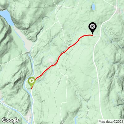
This 2.5 mile bike climb is located in CT, USA. The average gradient is 4.7% and there is a total elevation gain of 641 ft, finishing at 1,165 ft.
Use the profile tool, route map, and weather forecast to conquer this cycling climb.
Use the profile tool, route map, and weather forecast to conquer this cycling climb.
PLAN YOUR ROUTE
This climb averages 0%. The steepest quarter mile of this climb is 0%. NaN miles of the climb is at or above 10% grade. The gradient on this climb is broken down as follows:
See more details and tools regarding this climb's grade via our interactive Profile Tool.
See more details and tools regarding this climb's grade via our interactive Profile Tool.
Information Not Available
If you have any information regarding this climb, we'd like to hear from you. Click the CONTRIBUTE button to share your thoughts with us.
Information Not Available
If you have any information regarding this climb, we'd like to hear from you. Click the CONTRIBUTE button to share your thoughts with us.
Before heading out on any cycling adventure check out our Things to Bring on a Cycling Trip and use our interactive check list to ensure you don't forget anything.
Information Not Available
If you have any information regarding this climb, we'd like to hear from you. Click the CONTRIBUTE button to share your thoughts with us.
ROUTE MAP
MEMBER RATING
CURRENT WEATHER
PJAMM TRIPS ADVENTURE STARTER BUNDLES
Check out PJAMM Adventure's prepackaged (self-guided) cycling trips. They will help you plan, document and conquer your next adventure.
NEARBY CLIMBS (0) RADIAL PROXIMITY
FROM No Climbs Found
MEMBER REVIEWS & COMMENTS
Let us know what you thought of this climb. Signup for our FREE membership to write a review or post a comment.
Already have an account?
LOG IN HERE
farmano
This climb is the most obvious route to reach West/East Hartland from Riverton. Traffic is typically light and the shoulder is pretty good.The beginning of the climb can be a bit challenging but then the road descends to bit before a light, long steady climb to the top. The climbing really starts at the intersection with Hogback Road.Hogback is fabulous as it runs along the Farmington River and will take you to the Goodwin Dam, which is absolutely beautiful. Cycle to the top of Hogback for a killer workout and then turn right to get back to Riverton Road Route 20. On Strava the segment is "Rte 20 access to Rev".
2.46 miles - 632 Feet - 4.8%