Whitcomb Hill Road Bike Climb - PJAMM Cycling

1.8
FIETS
2 mi
DISTANCE
788 ft
GAINED
7.7 %
AVG. GRADE

FULL CLIMB STATS

Page Contributor(s): John Summerson, The Complete Guide to Climbing (by Bike) 2nd Ed; Dan Razum, San Jose, CA

INTRO

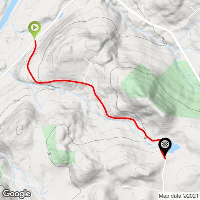
This 2 mile bike climb is located in CT, USA. The average gradient is 7.7% and there is a total elevation gain of 788 ft, finishing at 1,316 ft.

Use the profile tool, route map, and weather forecast to conquer this cycling climb.

See more details and tools regarding this climb's grade via our interactive Profile Tool.
Information Not Available

If you have any information regarding this climb, we'd like to hear from you. Click the CONTRIBUTE button to share your thoughts with us.

Information Not Available

If you have any information regarding this climb, we'd like to hear from you. Click the CONTRIBUTE button to share your thoughts with us.

Before heading out on any cycling adventure check out our Things to Bring on a Cycling Trip and use our interactive check list to ensure you don't forget anything.
Information Not Available

If you have any information regarding this climb, we'd like to hear from you. Click the CONTRIBUTE button to share your thoughts with us.

ROUTE MAP

MEMBER RATING

Difficulty: Moderate
3
Road
5
Traffic
3
Scenery

CURRENT WEATHER

PJAMM TRIPS ADVENTURE STARTER BUNDLES

Check out PJAMM Adventure's prepackaged (self-guided) cycling trips. They will help you plan, document and conquer your next adventure.
ALL TRIPS
Browse all of our prepackaged trips and find your next adventure!
Northeast Fall Colors
United States (MA,ME,NH,NY,VT)
24 ROUTES
37 POIs
ROUTE STATS (TOTAL)
98
mi
DISTANCE
35,116
ft
ELEV. GAIN

NEARBY CLIMBS (0) RADIAL PROXIMITY

FROM
No Climbs Found

MEMBER REVIEWS & COMMENTS

Let us know what you thought of this climb. Signup for our FREE membership to write a review or post a comment.
Already have an account?

May 22, 2021
difficulty: Moderate
scenery: 3
traffic: 5
road: 3
May 22, 2021
scenery: 3
traffic: 5
road: 3
Perhaps the most difficult climb in CT, as with hills such as Kingsley Hill Rd in MA and Tanners Ridge Rd in VA, Whitcomb Hill punches you in the face very early on the ascent. Like the dark woods over most of its route as well. Watch the last bit if you decide to descend it.
ROUTE MAP
PROFILE TOOL
Route Data
S.G. (%)
hide
Segment Data
hide

Climb Profile Not Found
CLIMB SUMMARY

Cycling Whitcomb Hill Road

Ride 2 miles gaining 788’ at 7.7% average grade.

This is the second hardest climb in Connecticut due to its steep gradient - the climb includes a 13% quarter mile segment and 11.4% for one-half mile.

Climb start

John Summerson summary:

“A climb more brutal that its statistics suggest, Whitcomb Hill Road may be the most difficult in the state of Connecticut as it contains severe grade in places.  From the start at its junction with Route 7, be ready early as the slope is double digit to begin and just gets steeper.  Soon you hit the maximum on the hill as you ride the narrow and deeply wooded track.  Little traffic at least allows you to concentrate on the task at hand.  After this shock to the system, pedaling eases but remains challenging before easing further to almost flat.  Soon a guard rail appears on the right indicating the halfway point in the ascent.

The road curves to the left as you continue to gain altitude.  A few houses then begin to appear and the grade slowly increases again.  Keep turning the pedals as the slope soon ramps back up to double digit for the finishing stretch.  Finally the woods part as you approach a red barn on the right and a white house on the left in somewhat open ground.  Just beyond, the road goes flat where the listed hill ends.  Is Whitcomb Hill Road the most difficult paved hill climb in Connecticut?  There are many in contention for this honor so you decide.  Its grade’ and tight routing make for a challenging descent as well.” (This quote is provided with the approval of John Summerson from his book, The Complete Guide to Climbing (by Bike) in the Northeast, pg. 60.)

Climb summary by PJAMM ambassador Dan Razum.

The climb starts at the intersection with Rte 7 and it starts out with a bang, almost 15% slope right from the beginning.  The first half mile or so averages about 10% slope before backing off a little bit for the next half mile.  It then alternates between steep and moderate sections, with the steep sections comprising more distance than the moderate sections.  The beginning is the steepest part of the climb but there are several 10% sections sprinkled throughout.  You will have to

work hard on this climb.

When we reach a red barn on the left, it signals the last of the steep sections and the end is near. The top is shortly after the red barn and it is indicated by 3 tall pine trees on the left, near a driveway.

The road is in decent condition, not perfect, but good enough.  There are no markings on the pavement and the roadway is a bit narrow but there is very little traffic.

Finish