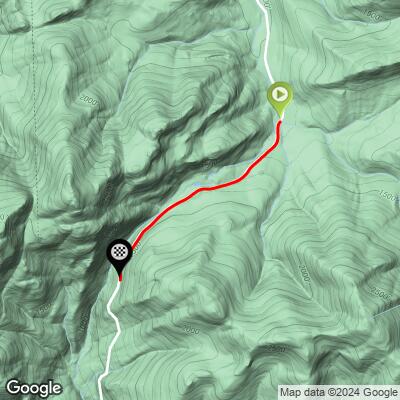
Evans Notch North Bike Climb - PJAMM Cycling

0.4
FIETS
2.1 mi
DISTANCE
406 ft
GAINED
3.4 %
AVG. GRADE

FULL CLIMB STATS

Page Contributor(s): John Summerson, The Complete Guide to Climbing (by Bike) 2nd Edition; Bruce Hamilton and Stacy Topping, Midway, UT; Dan Razum, San Jose, CA

INTRO

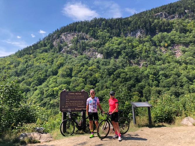
“One of the most scenic climbs in the Northeast, the south side of Evans Notch, located near the New Hampshire border, is also very isolated. The road is quite narrow and dark in places as it carries you up to the notch through a tunnel of trees and with little traffic most days. A fairly shallow start, the grade soon ramps up before you encounter a stretch of flat riding. Soon climbing resumes over moderate grade and the hill eventually enters deep woods and contains extended double digit grade toward the summit and can make you work for its scenic top. The summit is obvious and there are hiking possibilities at the notch as well.” (This quote is presented with the approval of John Summerson, from his book, The Complete Guide to Climbing (by Bike) in the Northeast, pg. 65.)

See more details and tools regarding this climb's grade via our interactive Profile Tool.
Information Not Available

If you have any information regarding this climb, we'd like to hear from you. Click the CONTRIBUTE button to share your thoughts with us.

Information Not Available

If you have any information regarding this climb, we'd like to hear from you. Click the CONTRIBUTE button to share your thoughts with us.

Before heading out on any cycling adventure check out our Things to Bring on a Cycling Trip and use our interactive check list to ensure you don't forget anything.
Information Not Available

If you have any information regarding this climb, we'd like to hear from you. Click the CONTRIBUTE button to share your thoughts with us.

ROUTE MAP

MEMBER RATING

Not Yet Rated
-
Road
-
Traffic
-
Scenery

CURRENT WEATHER

PJAMM TRIPS ADVENTURE STARTER BUNDLES

Check out PJAMM Adventure's prepackaged (self-guided) cycling trips. They will help you plan, document and conquer your next adventure.
ALL TRIPS
Browse all of our prepackaged trips and find your next adventure!
Northeast Fall Colors
United States (MA,ME,NH,NY,VT)
24 ROUTES
37 POIs
ROUTE STATS (TOTAL)
98
mi
DISTANCE
35,116
ft
ELEV. GAIN

NEARBY CLIMBS (0) RADIAL PROXIMITY

FROM
No Climbs Found

MEMBER REVIEWS & COMMENTS

Let us know what you thought of this climb. Signup for our FREE membership to write a review or post a comment.
Already have an account?
ROUTE MAP
PROFILE TOOL
Route Data
S.G. (%)
hide
Segment Data
hide

Climb Profile Not Found
CLIMB SUMMARY

Cycling Evans Notch (#5 Maine from the north and #10 from the south)

Start of climb.

John Summerson:

“The north side of Evans Notch is a shallow grade hill close to the New Hampshire border.  The road is quite narrow and the last mile carries more solid (but not steep) slope.  It ends at the obvious notch in a pleasant setting.” (This is quote presented with the approval of John Summerson, from his book, The Complete Guide to Climbing (by Bike) in the Northeast, pg. 65.)

Climb summary by PJAMM ambassador BFF Bruce Hamilton:

Evans Notch is a relatively easy climb that can be ridden over and back to do both sides on the same ride. Very scenic and quiet with little traffic the road winds mostly through the forest with an opening at the summit providing a nice view. The ride from the south side starts on the Maine-New Hampshire border and this is the westernmost ride in Maine. Not difficult by PJAMM standards but a scenic and enjoyable ride – would be particularly nice to ride during autumn.

Thanks much Bruce and Stacy!!

Climb summary by PJAMM ambassador Dan Razum.

The climb proper starts as we ride over Stony Brook. However, the road has a slight incline for a couple of miles before reaching Stony Brook. So if you start earlier, perhaps near Hastings Campground or Wild River, you will have a gentle gradient before reaching Stony Brook.  After crossing the bridge over Stony Brook the gradient changes from 1~2% to 5~6%, which is noticeable.

The climb isn't too long, only a couple of miles and most of the climbing is in the first mile. The second mile is rolling terrain, a little climbing mixed with a little downhill and flat sections. The road is narrow but it is in good condition.  There are no lane markings, so no official shoulder, but traffic is light; there are no houses along the road so the cars are tourists and visitors.

We pass through a thick forest the whole time which provides a lot of shade but no scenic views.  As we reach the top of the climb the forest parts and there is a nice scenic view of the mountains and valley  below. You are likely to encounter some cars or motorcycles at the top, admiring the view.

View at the top of the climb.