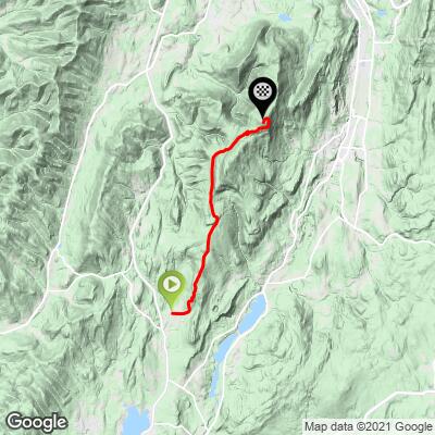
10.8
PDI
8.9 mi
DISTANCE
2,273 ft
GAINED
4.5 %
AVG. GRADE
FULL CLIMB STATS
Page Contributor(s): John Summerson, The Complete Guide to Climbing (By Bike), 2nd Edition; Fran Armentano, North Granby, CT
INTRO
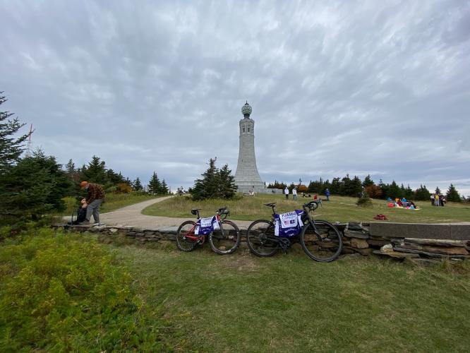
This 8.9 mile bike climb is located in MA, USA. The average gradient is 4.5% and there is a total elevation gain of 2,273 ft, finishing at 3,370 ft.
Use the profile tool, route map, and weather forecast to conquer this cycling climb.
Use the profile tool, route map, and weather forecast to conquer this cycling climb.
PLAN YOUR ROUTE
See more details and tools regarding this climb's grade via our interactive Profile Tool.
Information Not Available
If you have any information regarding this climb, we'd like to hear from you. Click the CONTRIBUTE button to share your thoughts with us.
Information Not Available
If you have any information regarding this climb, we'd like to hear from you. Click the CONTRIBUTE button to share your thoughts with us.
Before heading out on any cycling adventure check out our Things to Bring on a Cycling Trip and use our interactive check list to ensure you don't forget anything.
The two times we have cycled Greylock we have stayed in Williamstown at the Williamstown Motel, which has great ownership and is a nice and reasonable place to stay. House and cottage rentals are also available in the area.
ROUTE MAP
MEMBER RATING
CURRENT WEATHER
PJAMM TRIPS ADVENTURE STARTER BUNDLES
Check out PJAMM Adventure's prepackaged (self-guided) cycling trips. They will help you plan, document and conquer your next adventure.
NEARBY CLIMBS (0) RADIAL PROXIMITY
FROM No Climbs Found
MEMBER REVIEWS & COMMENTS
Let us know what you thought of this climb. Signup for our FREE membership to write a review or post a comment.
Already have an account?
LOG IN HERE
Heather
This is a long but not too steep climb. The hardest part is in the beginning. The traffic is very light (we started our ascent around 10:00 am on a Friday) and had about 5 cars the entire way. There are numerous places to take breaks where you can easily be off the road. There are only a few switch backs.
johnpotash
The descent was freezing as I was not prepared - needed winter gloves and light jacket next time I ride so late in season
sarahbingham
Was doable for a relatively new rider. Can't beat that trip down the mountain after such great views!