Mohawk Trail West Bike Climb - PJAMM Cycling

2.1
FIETS
4.1 mi
DISTANCE
1,226 ft
GAINED
5.7 %
AVG. GRADE

FULL CLIMB STATS

Page Contributor(s): John Summerson, The Complete Guide to Climbing (By Bike), 2nd Edition

INTRO

This 4.1 mile bike climb is located in MA, USA. The average gradient is 5.7% and there is a total elevation gain of 1,226 ft, finishing at 2,008 ft.

Use the profile tool, route map, and weather forecast to conquer this cycling climb.

See more details and tools regarding this climb's grade via our interactive Profile Tool.
Information Not Available

If you have any information regarding this climb, we'd like to hear from you. Click the CONTRIBUTE button to share your thoughts with us.

Information Not Available

If you have any information regarding this climb, we'd like to hear from you. Click the CONTRIBUTE button to share your thoughts with us.

Before heading out on any cycling adventure check out our Things to Bring on a Cycling Trip and use our interactive check list to ensure you don't forget anything.
Information Not Available

If you have any information regarding this climb, we'd like to hear from you. Click the CONTRIBUTE button to share your thoughts with us.

ROUTE MAP

MEMBER RATING

Not Yet Rated
-
Road
-
Traffic
-
Scenery

CURRENT WEATHER

PJAMM TRIPS ADVENTURE STARTER BUNDLES

Check out PJAMM Adventure's prepackaged (self-guided) cycling trips. They will help you plan, document and conquer your next adventure.
ALL TRIPS
Browse all of our prepackaged trips and find your next adventure!
Northeast Fall Colors
United States (MA,ME,NH,NY,VT)
24 ROUTES
37 POIs
ROUTE STATS (TOTAL)
98
mi
DISTANCE
35,116
ft
ELEV. GAIN

NEARBY CLIMBS (0) RADIAL PROXIMITY

FROM
No Climbs Found

MEMBER REVIEWS & COMMENTS

Let us know what you thought of this climb. Signup for our FREE membership to write a review or post a comment.
Already have an account?
ROUTE MAP
PROFILE TOOL
Route Data
S.G. (%)
hide
Segment Data
hide

Climb Profile Not Found
CLIMB SUMMARY

Cycling Mohawk Trail West, Massachusetts - road signs read "Steep Hill - Curves, Next Mile Use Caution"

Cycling Mohawk Trail West, Massachusetts

Ride 4.1 miles gaining 1,235’ at 5.7% average grade.

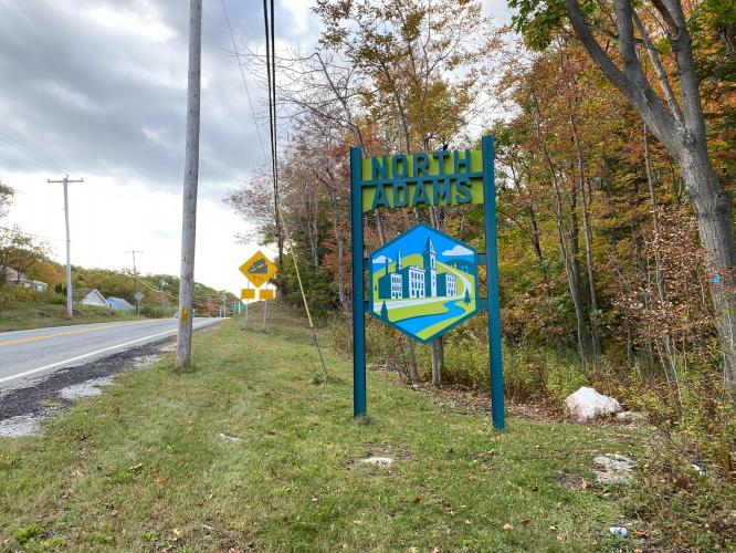
This climb begins in North Adams just a few hundred yards from the start of the amazing Mount Greylock bike climb. The steepest part of the climb is ¼ mile near the beginning that averages 8%.

Cycling Mohawk Trail West, Massachusetts - sign for North Adams on side of road

“The west side of Route 2 is a steady grade climb with traffic from picturesque North Adams in western Massachusetts.  An easy start in town soon leads to increased grade but there are no real surprises on this one.  Eventually you encounter a big hairpin turn to the right as you ascend the ridgeline.  Soon the grade eases up to the obvious summit.  The traffic will be with you on this one most days but is a worthwhile climb and a fast descent back into town except for the tight switchback and vehicles at times.” (This quote is provided with the approval of John Summerson from his book, The Compete Guide to Climbing (by Bike) in the Northeast, pg. 74.)

Cycling Mohawk Trail West, Massachusetts - View from and of Golden Eagle Restaurant

The Golden Eagle Restaurant at the Route 2 Mohawk Trail Overlook.

Cycling Mohawk Trail West, Massachusetts - view from Wigwam Western Summit, fall foliage, sun beaming through clouds, white building on hillside overlooking view

Wigwam Western Summit,  just before the top.

Access to full Climb Summary requires a PJAMM Cycling PRO Membership!

It takes less than a minute to sign up & with your PRO membership you can:
  • Rate climbs, post comments and share your experiences on any of our climb pages
  • Create bucket lists of climbs & mark the dates you complete them
  • Weather data for all climbs - Start & Finish
  • Upload photos to your member page to customize your PJAMM Cycling experience
  • Utilize all of our interactive tools - Profile & Routes in Area
  • Download climb route .gpx files
LEARN MORE
SIGN UP

Already have an account? LOG IN HERE