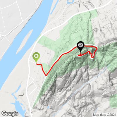
5.1
PDI
1.8 mi
DISTANCE
755 ft
GAINED
8 %
AVG. GRADE
FULL CLIMB STATS
INTRO
This 1.8 mile bike climb is located in MA, USA. The average gradient is 8% and there is a total elevation gain of 755 ft, finishing at 907 ft.
Use the profile tool, route map, and weather forecast to conquer this cycling climb.
Use the profile tool, route map, and weather forecast to conquer this cycling climb.
PLAN YOUR ROUTE
See more details and tools regarding this climb's grade via our interactive Profile Tool.
Information Not Available
If you have any information regarding this climb, we'd like to hear from you. Click the CONTRIBUTE button to share your thoughts with us.
Information Not Available
If you have any information regarding this climb, we'd like to hear from you. Click the CONTRIBUTE button to share your thoughts with us.
Before heading out on any cycling adventure check out our Things to Bring on a Cycling Trip and use our interactive check list to ensure you don't forget anything.
Information Not Available
If you have any information regarding this climb, we'd like to hear from you. Click the CONTRIBUTE button to share your thoughts with us.
ROUTE MAP
MEMBER RATING
CURRENT WEATHER
PJAMM TRIPS ADVENTURE STARTER BUNDLES
Check out PJAMM Adventure's prepackaged (self-guided) cycling trips. They will help you plan, document and conquer your next adventure.
NEARBY CLIMBS (0) RADIAL PROXIMITY
FROM No Climbs Found
MEMBER REVIEWS & COMMENTS
Let us know what you thought of this climb. Signup for our FREE membership to write a review or post a comment.
Already have an account?
LOG IN HERE
robertcarter10058


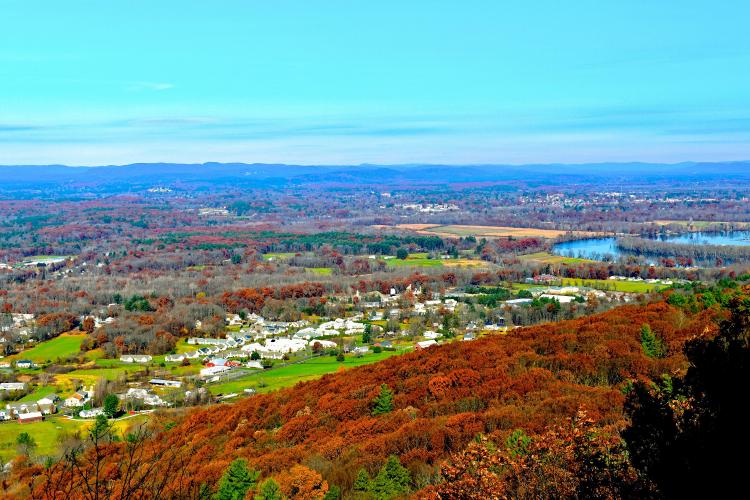
Cool little 10-15 minute climb with surprisingly amazing views at the top. The 8% average gradient is deceiving, as it is more like 2 distinct 11% sections with a break in the middle and a sneaky little 18% ramp in the early part of the climb. Great atmosphere through the trees if you go early enough to catch the morning fog. When I went, we were above the clouds at the top and the views of the valley were spectacular. If you live around the Springfield or Amherst area it's worth checking out, but if you aren't from New England there are better climbs elsewhere in the region that I would plan your trip around.
Mikey62481
Fun little climb! Easy to park and great views at the top. Only downside is it's short 1.8 miles but you can repeat if it's not enough…there's a good tough section at the beginning. Didn't feel like many cars just ppl walking, beautiful at the top!
mt_reilly
Road three laps on this hill this morning. Awesome all the way around. Light, but nonzero traffic. Great views at the summit. Not the most challenging climb. Steep in the bottom and top, with a little respit in the middle. Totally manageable. I increased a gear at each pass.
gertbfrobe
Have ridden this route a few times. Scenery at the top is awesome, able to see Pioneer Valley area. Last time in 2020 after coming down I went back up again to get double pleasure. Challenging is the beginning and at the end with some switchbacks as I used an 11/25. Plan to be back again this year with many more miles under my belt and with either a 11/28 or 12/30 so will see if times improve.