
6.4
PDI
2.5 mi
DISTANCE
986 ft
GAINED
7.4 %
AVG. GRADE
FULL CLIMB STATS
Page Contributor(s): Robert Rheault, Kernersville, North Carolina
INTRO
This 2.5 mile bike climb is located in NC, USA. The average gradient is 7.4% and there is a total elevation gain of 986 ft, finishing at 2,171 ft.
Use the profile tool, route map, and weather forecast to conquer this cycling climb.
Use the profile tool, route map, and weather forecast to conquer this cycling climb.
PLAN YOUR ROUTE
See more details and tools regarding this climb's grade via our interactive Profile Tool.
Information Not Available
If you have any information regarding this climb, we'd like to hear from you. Click the CONTRIBUTE button to share your thoughts with us.
Information Not Available
If you have any information regarding this climb, we'd like to hear from you. Click the CONTRIBUTE button to share your thoughts with us.
Before heading out on any cycling adventure check out our Things to Bring on a Cycling Trip and use our interactive check list to ensure you don't forget anything.
Information Not Available
If you have any information regarding this climb, we'd like to hear from you. Click the CONTRIBUTE button to share your thoughts with us.
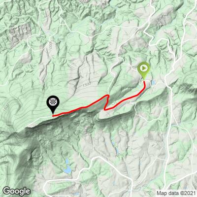
ROUTE MAP
MEMBER RATING
CURRENT WEATHER
PJAMM TRIPS ADVENTURE STARTER BUNDLES
Check out PJAMM Adventure's prepackaged (self-guided) cycling trips. They will help you plan, document and conquer your next adventure.
NEARBY CLIMBS (0) RADIAL PROXIMITY
FROM No Climbs Found
MEMBER REVIEWS & COMMENTS
Let us know what you thought of this climb. Signup for our FREE membership to write a review or post a comment.
Already have an account?
LOG IN HERE
RuhRoh

One of the three climbs part of the "Triple Hump" route. The other two are Pilot Mountain and Hanging Rock. This climb has no view at the top, but a nice view of Hanging Rock on the way down. It starts with a short but steep section, followed by a long gentle climb until you reach the first steep part. Another shallower section will allow you to rest a bit before the last kicker to the top.