Climb Summary
![IMG_6308.JPG]()
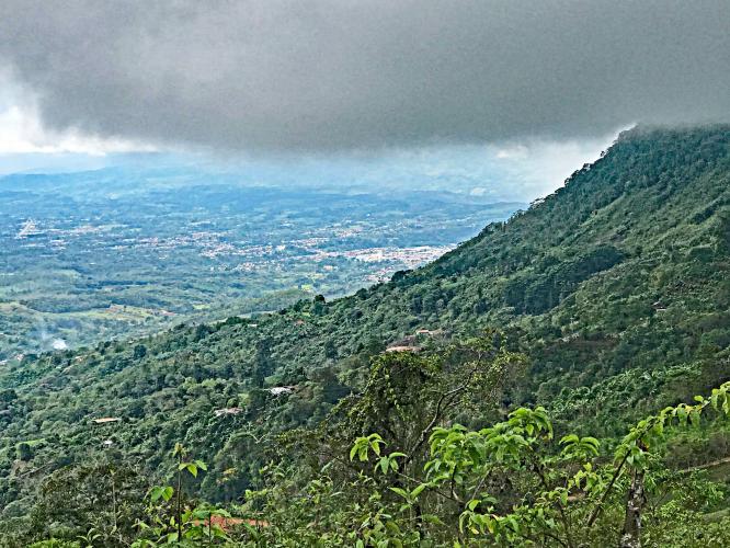
Gorgeous climb out of San Isidro, Costa Rica
Regrettably, we tackled this Top 50 World Climb during the Central American rainy season (May, 2017) and missed most of the breathtaking views of the steep, lush mountains surrounding us along this climb. The literal translation of Cerro de la Muerta is “hill of death”:
“Cerro de la Muerte is the highest point in the Costa Rican section of the Inter-American Highway. Its name means "Mountain of Death" or "Summit of Death," since in the past crossing the mountains from the Valle Central meant a three- or four-day journey, on foot or on horseback, and many ill-prepared travelers succumbed to the cold and rain. However, the peak is now easily accessible since the highway runs close by.” Wikipedia
![]()
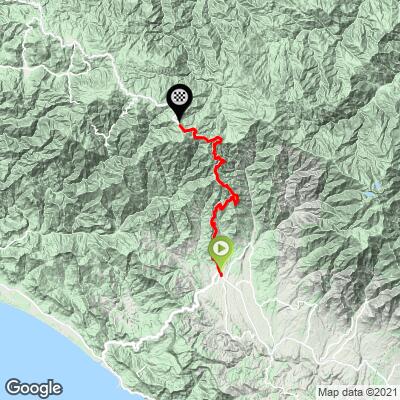
This was leg 2 of my Central America Top 100 climbs trip – Mombacho Volcano, Nicaragua was my first stop and boy, was that an adventure! I had planned in advance to meet Gabriel, a young cyclist I had met through Strava who lived in San Jose, Costa Rica and had ridden Cerro de la Muerta before. Gabriel suggested that we leave San Jose at 4:30 a.m. for the 3 hour trip to San Isidro de El General – the beginning of the climb.
Well, the best laid plans and all . . . the “earliest” (only) flight from Managua to San Jose didn’t leave until late evening and I did not arrive at my hotel until 11 p.m.. After putting the bike together, I hit the sack after midnight, but was up by 4 a.m. and ready to roll – excited to take on the mighty Mountain of Death with my Costa Rican cycling guide. But by 4:45 a.m. . . . no Gabriel. I logged onto email and received Gabriel’s message that he was very ill and regrettably could not accompany me for the ride that day. No matter . . . I was off.
Two things about this one that are memorable (in addition to the spectacular climb, of course) – (1) traffic in and around San Jose is horrible – extremely busy and chaotic late at night when I arrived and so to that early a.m. when I began my great adventure (travel tip: rent the GPS with your car and have the attendant program your main destinations at the rental office, including the rental office address), and (2) the rainy season is the reverse of the U.S. – Central America rainy season is roughly May to October.
![]()
Off into the bustling streets of San Jose and points south I went, alone, undeterred and excited for the climb ahead.
While the distance from San Jose to San Isidro de El General is a modest 133 kilometers (82 miles), the traffic around San Jose was a bear and getting up and over the very narrow and steep Highway 2 between San Jose and San Isidro is very slow going as this is a commercial route between those two major Costa Rican cities. Since the climb on both sides of the mountain are very long (totaling about 60 miles / 120 km) and there are no passing lanes or turn outs to speak of, the going averages around 20 miles per hour (32 kmh) with traffic. While it took me three hours to get those mere 80 miles, the good news is that I did not get lost and all systems were GO!
![IMG_0610.JPG]()
We are briefly in an commercial/urban area.
![]()
![IMG_0619.JPG]()
But quickly climb and stay in a very rural area
The climb itself is challenging as it averages 5.6% for 29 miles (46 km), making it one of the longest continuous grades in the world. The grade is fairly steady, never appreciably exceeding 8%.
Except for the traffic along this road, the climb is extraordinary (much of that comes from reports provided by others since I was socked in with rain and/or fog most of the climb). I am told there are magnificent views of the rugged and tropical mountains as we ascend (although he missed the bell for my ride, Gabriel will travel to and document the climb for us in late 2017). The views I did glimpse were outstanding and the roadway was always surrounded by lush tropical greenery.
The only non-weather-related negative about this climb is the traffic. There are a fair amount of big rigs and buses traveling this pass and, although they often struggle slowly up the hill, they can pass close and at higher speeds when they are gathering steam for an upcoming steep stretch. This climb is not for cyclists nervous around and/or sharing a narrow road with no shoulder with big vehicles I did not have any bad encounters, but traffic does necessarily come close, particularly if there is oncoming traffic and traffic in our direction cannot give us the mandatory 1.5 meters required in Costa Rica.
![]()
O.k. - now that looks good . . .
![]()
But, in real life . . . .
There is a nice and friendly cafeteria (Restaurante de Georgina) at mile 25 (kilometer 40), just at a false summit (continue riding .7 miles slightly downhill until the 3 miles/4.8 km final 5.2% segment to the top at nearly 11,000’.
![IMG_0684.JPG]()
![IMG_6317.JPG]()
![IMG_0697.JPG]()
The end of a very wet day . . .
Climbing to altitude - even in Central America - come prepared for a 20 degree temperature change - on our trip, it was 70 (20 celsius) (degrees, shirtsleeve weather in San Isidro de El General but low 52 (11c) at the top.
PJAMM Final thoughts: Cerro de la Muerte is a very long and challenging climb to altitude. The roadway is a bit hazardous, so definitely beware there – bring flashing rear lights. This is not a “destination climb” (we would not make a special trip for this one, in other words), but, if you are anywhere in the area (even San Jose), it is worth the effort to get to and ride up!
Steepest Gradients by Distance
![Grades.JPG]()