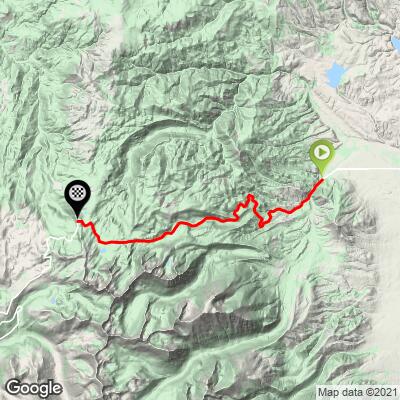
Elkhorn Summit Bike Climb - PJAMM Cycling

7
FIETS
12.5 mi
DISTANCE
3,643 ft
GAINED
5.4 %
AVG. GRADE

FULL CLIMB STATS

Page Contributor(s): Ron Hawks, Las Vegas, Nevada, USA; Bruce Hamilton, La Quinta, CA, USA

INTRO

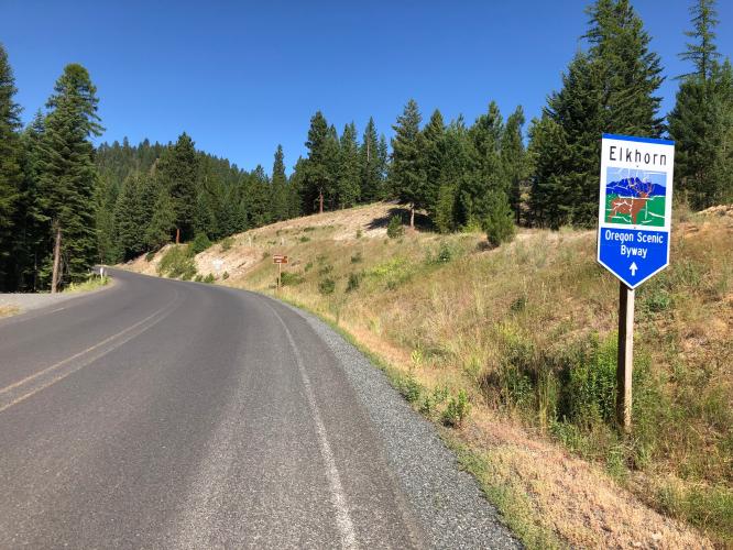
Elkhorn Summit is the fourth hardest bike climb in Oregon.  This climb starts about 12 miles out of the tiny northeastern Oregon town of Haines and travels 10.3 miles up to Anthony Lakes Mountain Resort (ski/snowboard resort). This climb is an outlier as it is 281 miles from the next Top 100 climb (Hood Mountain near Portland).

"The highest paved road in Oregon, Elkhorn Summit is an isolated climb and likely the most difficult in the western part of the state. A shallow start gives way to a very steady grade climb on a narrow road within thick trees over much of its route. The road switchbacks up the hill in places but is never steep. The listed climb ends at an unmarked summit..." (This quote is presented with the approval of John Summerson, from his book, The Complete Guide to Climbing (by Bike), 2nd Edition, pg. 206.)
5.4% average grade (5.9% climb only).  64% of the climb is at 5-10%.  The steepest quarter-mile is 9.9% and steepest mile 9%.  

See more details and tools regarding this climb's grade via the “Profile Tool” button.
Roadway:  Two lane road with narrow shoulder the entire route with pavement in good condition.  

Traffic:  Mild.

Parking:  At the bridge where the climb begins (MapStreet View). 
Provisions:  None on the route.  Food and beverages in Haines, nine miles east of climb start. 
Before heading out on any cycling adventure check out our Things to Bring on a Cycling Trip and use our interactive check list to ensure you don't forget anything.
This is an isolated climb in northeastern Oregon with no other top climbs nearby. 

ROUTE MAP

MEMBER RATING

Difficulty: Challenging
3
Road
5
Traffic
5
Scenery

CURRENT WEATHER

PJAMM TRIPS ADVENTURE STARTER BUNDLES

Check out PJAMM Adventure's prepackaged (self-guided) cycling trips. They will help you plan, document and conquer your next adventure.
ALL TRIPS
Browse all of our prepackaged trips and find your next adventure!
Crater Lake
United States (OR)
10 ROUTES
29 POIs
ROUTE STATS (TOTAL)
258.3
mi
DISTANCE
29,750
ft
ELEV. GAIN

NEARBY CLIMBS (0) RADIAL PROXIMITY

FROM
No Climbs Found

MEMBER REVIEWS & COMMENTS

Let us know what you thought of this climb. Signup for our FREE membership to write a review or post a comment.
Already have an account?

Jul 10, 2023
Great, steady climb that never gets too steep. Driving through with no knowledge of the area so I parked my car at a Wildlife Viewing spot here: 45.02453060937804, -118.07304796704614. No huge scenery views but the view at Anthony Lake was nice. Fun way to stretch your legs if you're stuck in the car too long.
Jul 30, 2021
difficulty: Challenging
scenery: 5
traffic: 5
road: 3
Jul 30, 2021
scenery: 5
traffic: 5
road: 3
I was racing it, at the end of a 4 stage stage race. I started the climb 75 miles into the stage, I struggled to keep my power in the 260s and as it gotta hotter and hotter I started getting heatstroke. I grabbed a neutral bottle from a support car at about 7 miles in, I started the climb with 750ml of EFS and 550of ultragen grabbed at the feedzone need the base. it was tough, but not as tough as hurricane ridge in Washington, but harder than sunrise. The altitude really gets you as you pass 6k'. I wish I lived in Baker city because the climb is just so epic. Be prepared for there to be little to no shade though.
ROUTE MAP
PROFILE TOOL
Route Data
S.G. (%)
hide
Segment Data
hide

Climb Profile Not Found
CLIMB SUMMARY

IMG_5636.JPG

Cycling Elkhorn Summit in northeastern Oregon.

Ride 10.4 miles gaining 3,647’ to elevation 7,220’ at 6.4% average grade.

This climb starts about 12 miles out of the tiny northeastern Oregon town of Haines and travels 10.3 miles up to Anthony Lakes Mountain Resort (ski/snowboard resort).  This climb is an outlier as it is 281 miles from the next Top 100 climb (Hood Mountain near Portland).

IMG_5636.JPG 

   IMG_5657.JPG

Oddly, there is no Strava segment to the top of Elkhorn Summit.  The main Strava Segment (The Anthony Climb) ends at the first of two summits, just before the .8 mile -2% 99’ descent that begins at mile 10.8.  Ride 2 miles past the start of the descent to reach the true summit.

IMG_5657.JPG

Thanks much Bruce!

Steepest ¼ mile begins at mile 1.5 (11.4%) and steepest mile at 8.8 (9.6%)

The aptly named  LaGrandeRide.com  provides an excellent summary of this climb, which includes the following:

Finishing this climb in less than an hour is very fast. Most should expect to be climbing for well-over an hour. The pain begins immediately upon crossing a small bridge over the Powder River as the road immediately turns sharply upward on some very rough pavement. The climbing eases up a bit upon entering the Wallowa-Whitman National Forest, where the road surface also improves considerably. At one point, the road nearly levels for a very short reprieve and then returns to the consistently steep gradients that characterize the climb. The only other relief is a 5 percent grade at the trai head entrance for Van Patten Lake. For the remainder of the climb the air gets thinner, pavement starts to degrade, and the road gets even more serious. Two long straight stretches demoralize the climber near the top, because the road appears to continue upward indefinitely. Eventually the road crests at an inauspicious section that gives very little indication that the violence has culminated. At this point, ego-oriented climbers should stop their watches because the official climb is complete—start timer at bridge, go all out, stop timer at dirt road on the right where the climbing stops, work done. Anthony Lakes Campground is just a quarter mile down the road, and offers a gorgeous setting to rest and refill water bottles. Cyclists should exercise caution on the descent, watching for anomalies in the road, loose gravel, and oncoming traffic on the corners.  While the climb does offer a few beautiful views of the Baker Valley and the Wallowa Mountains to the East, the true beauty is in the physical effort required to ride this climb. For riders who take time to sit up and enjoy their surroundings, there are other scenic offerings. The road takes the cyclist through thickly forested ponderosa and tamarack pines in the lower elevations. At higher elevations the trees get shorter and more sparse, giving way to white granite rocks and mountainous terrain that is characteristic of the Elkhorn mountains, a tall range sandwiched between the Blue Mountains and Wallowa Mountains. The road follows Antone Creek for most of the climb and then bisects Bear Butte and Van Patten Butte before topping out and entering the Anthony Lakes basin. The Anthony Lakes area hosts a variety of recreational opportunities throughout the year. Winter sports include nordic and alpine skiing and snowmobiling. Summer activities include mountain climbing, mountain biking, fishing, canoeing, hiking, and camping. A few things that may be experienced on the ride: mountain goats, big horn sheep, bear, elk, bald eagles, turkeys, and maybe prong-horned antelope.

Thank you to LaGrandeRide.com - The Anthony Climb for this excellent summary.


Access to full Climb Summary requires a PJAMM Cycling PRO Membership!

It takes less than a minute to sign up & with your PRO membership you can:
  • Rate climbs, post comments and share your experiences on any of our climb pages
  • Create bucket lists of climbs & mark the dates you complete them
  • Weather data for all climbs - Start & Finish
  • Upload photos to your member page to customize your PJAMM Cycling experience
  • Utilize all of our interactive tools - Profile & Routes in Area
  • Download climb route .gpx files
LEARN MORE
SIGN UP

Already have an account? LOG IN HERE