Kolob Terrace Road Bike Climb - PJAMM Cycling

7.1
FIETS
19.3 mi
DISTANCE
4,672 ft
GAINED
4.3 %
AVG. GRADE

FULL CLIMB STATS

Page Contributor(s): Bruce Hamilton/Stacy Topping, USA Ron Cushing, Cedar City, Utah, USA Erich Pawelka, Vienna, Austria

INTRO

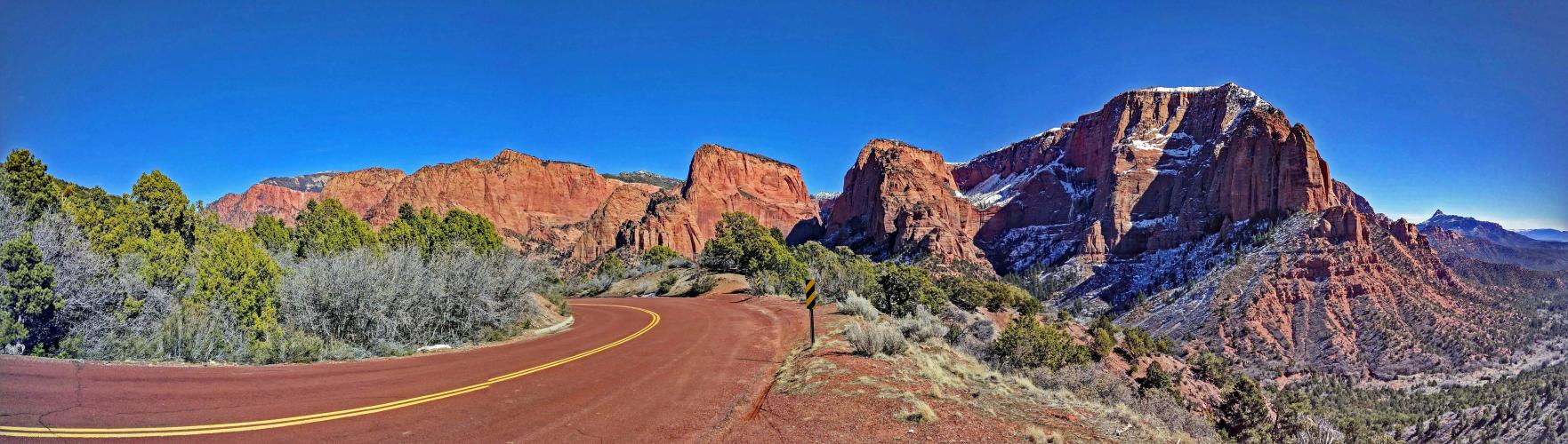
Cycling Kolob Terrace: one of the most picturesque bike climbs in Utah and the United States. On this ride we enter the extraordinary Zion National Park through the back door (see PJAMM's Zion NP climb area page for more information on Zion National Park).
Average grade is 4.3% (5.5% climb only).  16% of the climb is descent, 41% at 0-5%, 30% at 5-10% and 12% at 10-15%.  The steepest quarter mile is 11.7% and steepest mile 9.4%.  Most of the descent is the 3 miles getting you to the finish at Kolob Reservoir.

See more details and tools regarding this climb's grade via the “Profile Tool” button.
Roadway:  As you would expect in a national park, the roadway is in excellent condition. 

Traffic:  Minimal.

Parking:  At climb start, just before the small bridgte - Map; Street View

Entrance to National Park:  There is no fee to enter this portion of Zion NP. 
Provisions:  You can get food and drinks at the Kolob General Store at mile 17.3 - Map; Street View.
Before heading out on any cycling adventure check out our Things to Bring on a Cycling Trip and use our interactive check list to ensure you don't forget anything.
We stayed in Springdale 16 miles from the start of this climb and used that as our staging area for the breathtaking climbs in the area.  Springdale also has options for vacation rentals as well.

See PJAMM's Climb Area Page:  Zion National Park.
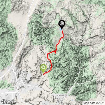
ROUTE MAP

MEMBER RATING

Difficulty: Strenuous
4
Road
4.3
Traffic
4.3
Scenery

CURRENT WEATHER

PJAMM TRIPS ADVENTURE STARTER BUNDLES

Check out PJAMM Adventure's prepackaged (self-guided) cycling trips. They will help you plan, document and conquer your next adventure.
ALL TRIPS
Browse all of our prepackaged trips and find your next adventure!
The American Southwest
United States (AZ,NM,UT)
18 ROUTES
27 POIs
ROUTE STATS (TOTAL)
215.4
mi
DISTANCE
34,866
ft
ELEV. GAIN
Utah: Moab, Arches & Canyonlands
United States (UT)
19 ROUTES
21 POIs
ROUTE STATS (TOTAL)
325.3
mi
DISTANCE
32,871
ft
ELEV. GAIN
Utah: Zion National Park
United States (UT)
20 ROUTES
32 POIs
ROUTE STATS (TOTAL)
256.5
mi
DISTANCE
39,649
ft
ELEV. GAIN

NEARBY CLIMBS (0) RADIAL PROXIMITY

FROM
No Climbs Found

MEMBER REVIEWS & COMMENTS

Let us know what you thought of this climb. Signup for our FREE membership to write a review or post a comment.
Already have an account?

Jul 13, 2023
difficulty: Strenuous
scenery: 4
traffic: 5
road: 4
Jul 13, 2023
scenery: 4
traffic: 5
road: 4
July 10, 2023 Did this climb as part of a long ride from Springdale. 98° so started early. An easy, gradual 12 mile decent from Springdale to Kolob Terrace rd and the start of the climb. A nice, gradual climb out of the river valley and through Zion NP - in & out 2 times - with 4 cattle guards to cross. Toughest part are the straight-up staircase climbs just past a picturesque part of Zion NP. A short decent to a moderate switchbacked climb gets you into cooler air then easier climbing and descending to the lake at the top where the pavement ends. To the left near the restroom is a cold water spigot. Much appreciated ! A fun fast decent back into the desert heat, then a gradual climb back to Springdale and up the Zion Scenic road to the end at the temple - more cold water, then back to Springdale. RT : 103 miles, 7100ft of climbing.
Mar 13, 2023
difficulty: Strenuous
scenery: 5
traffic: 4
road: 4
Mar 13, 2023
scenery: 5
traffic: 4
road: 4
One of the most scenic climbs in the Southwest. As of 2022 traffic is still relatively light, but increasing development will change that. The toughest part is a one mile straight stretch at mile 10 or so, when climbing up to Hop Valley. The switch backy part later on looks more intimidating but is easier since it is relatively short. The last 4 miles are more up and down.
May 21, 2021
difficulty: Strenuous
scenery: 4
traffic: 4
road: 4
May 21, 2021
scenery: 4
traffic: 4
road: 4
Climbed this route Saturday, May 15, 2021. I started a little further down the road where I had car camped the night prior, and my total distance/elevation was 22.5 miles / 5000 feet. The steeper sections at the beginning of the ride are pretty tough if you've been doing a lot of national park hiking / riding, but, at the same time, the views at the start of the ride are phenomenal. The views towards the end when you get through Zion and into the Kolob community are pretty weak, but the ride also gets much easier at that point. Even on a Spring Saturday, traffic wasn't bad at all. I'd definitely recommend this as a tough ride for the avid cyclist around Zion. As a side, if you're camping, this road has tons of options, which was super convenient for me.
ROUTE MAP
PROFILE TOOL
Route Data
S.G. (%)
hide
Segment Data
hide

Climb Profile Not Found
CLIMB SUMMARY

Cycling Kolob Terrace Road - aerial drone photo of road and mountains

Cycling Kolob Terrace: On of the most scenic US bike climbs

Ride 15.4 glorious miles gaining 4,400’ to elevation 7,989 at 5.2% average grade.

Visit our Zion National Park page. 

Climb summary by PJAMM’s John Johnson.

Before heading to Zion on your cycling adventure, be sure to rely on our list of Things to Bring on a Cycling Trip, and use our interactive checklist to ensure you don't forget anything.

Bicycle ride up Kolob Terrace - red rock mountain formations bike and roadway

A US Top 10 Most Scenic Bike Climb

This amazing bike climb has incredible views of Southern Utah rock formations, enters and skirts the western edge of Zion National Park, and ends just short of Blue Springs Reservoir and Kolob Peak.  The toughest part of the climb is the very scenic stretch from miles three through five, which averages 8.4%.    

The Kolob Terrace Road bike climb takes us towards Kolob Mountain, in the Colorado Plateau Province, covering parts of the four corners area (western Colorado, northwestern New Mexico, southern and eastern Utah, and northern Arizona).

Bicycle ride of Kolob Terrace Road - start - roadway and mountains - cycllist on bike

Start four miles north of Virgin, Utah.

Sunset Canyon Ranch at mile 0.8.

Climbing Kolob Terrace by bike - cyclist at Zion National Park Sign with bike

Enter the great Zion National Park at mile two.

Tabernacle Dome at mile 5.5.

Climbing by bike Kolob Terrace Road - cyclist on road with Red Butte in background

Red Butte (cone, center photo) as seen from mile 5.8.

Bicycle ride Kolob Terrace Road - cyclist on road riding past Share the Road Sign 

Entering Cave Valley at mile 7.5.

Cave Valley from the air.

Aerial drone photo of Cave Valley on Kolob Terrace Road

By the mid point of the climb we are in an alpine setting.

Cycling Kolob Terrace - bike on snowbank

Beware of the weather! It is best to travel here May through September . . .

. . . or, at least keep an eye on the weather forecast. .

Kolob Terrace bike climb - finish - roadway and forest

Kolob Mountain at mile 17 - market and provisions here.

Aerial drone photo of Cave Valley on Kolob Terrace Road

End of this stunningly beautiful ride at Kolob Reservoir.

Aerial drone photo of Cave Valley on Kolob Terrace Road

Thank you Bruce and Stacy!!


This Top 100 US Bike Climb is the southern and most remote (300 miles south of Salt Lake City) road cycling location in Utah.  However, this is truly a spectacular destination and worth the effort to travel to.

Cycling Kolob Terrace Road - John Johnson PJAMM with bike and rock formations in background

We LOVE the Kolob Terrace bike climb - one of the greatest in the US.

Steepest ¼ mile begins at mile 4.5 (11.7%) and steepest mile begins at 4.1 (9.4%)

Traffic and Roadway Report:  As of October, 2019, the roadway surface was very good and the traffic along this route is minimal.  This is an excellent road for cycling.

Access to full Climb Summary requires a PJAMM Cycling PRO Membership!

It takes less than a minute to sign up & with your PRO membership you can:
  • Rate climbs, post comments and share your experiences on any of our climb pages
  • Create bucket lists of climbs & mark the dates you complete them
  • Weather data for all climbs - Start & Finish
  • Upload photos to your member page to customize your PJAMM Cycling experience
  • Utilize all of our interactive tools - Profile & Routes in Area
  • Download climb route .gpx files
LEARN MORE
SIGN UP

Already have an account? LOG IN HERE