9.8
PDI
3.5 mi
DISTANCE
1,449 ft
GAINED
7.9 %
AVG. GRADE
FULL CLIMB STATS
Page Contributor(s): Alex Mann, USA
INTRO
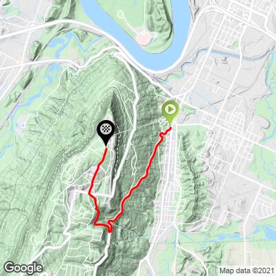
This 3.5 mile bike climb is located in TN, USA. The average gradient is 7.9% and there is a total elevation gain of 1,449 ft, finishing at 2,147 ft.
Use the profile tool, route map, and weather forecast to conquer this cycling climb.
Use the profile tool, route map, and weather forecast to conquer this cycling climb.
PLAN YOUR ROUTE
This climb averages 0%. The steepest quarter mile of this climb is 0%. NaN miles of the climb is at or above 10% grade. The gradient on this climb is broken down as follows:
See more details and tools regarding this climb's grade via our interactive Profile Tool.
See more details and tools regarding this climb's grade via our interactive Profile Tool.
Most days, Ochs highway is a fairly busy road with not much paved shoulder. In the summer tourists heading to Rock City move up and down in a steady stream. If you want to avoid traffic, early mornings on Sundays or holidays would be best.
Information Not Available
If you have any information regarding this climb, we'd like to hear from you. Click the CONTRIBUTE button to share your thoughts with us.
Before heading out on any cycling adventure check out our Things to Bring on a Cycling Trip and use our interactive check list to ensure you don't forget anything.
Information Not Available
If you have any information regarding this climb, we'd like to hear from you. Click the CONTRIBUTE button to share your thoughts with us.
ROUTE MAP
MEMBER RATING
CURRENT WEATHER
PJAMM TRIPS ADVENTURE STARTER BUNDLES
Check out PJAMM Adventure's prepackaged (self-guided) cycling trips. They will help you plan, document and conquer your next adventure.
NEARBY CLIMBS (0) RADIAL PROXIMITY
FROM No Climbs Found
MEMBER REVIEWS & COMMENTS
Let us know what you thought of this climb. Signup for our FREE membership to write a review or post a comment.
Already have an account?
LOG IN HERE
Bootsc


There are many options riding around this mountain but going all the way up to Point Park is definitely a must do. You have to pay to get into the park but there are great views just down the road from the park entrance. There is quite a bit of traffic on the weekend but not dangerous since cars really can't go that fast and they are generally courteous.