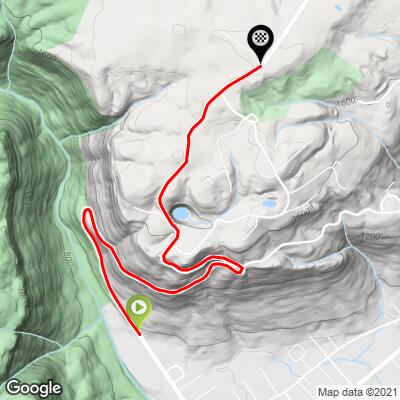
6.3
PDI
3.4 mi
DISTANCE
1,111 ft
GAINED
6.2 %
AVG. GRADE
FULL CLIMB STATS
Page Contributor(s): Eric Kuehl, Chicago, IL, USA; Todd Short, Scottsdale, AZ, USA
INTRO
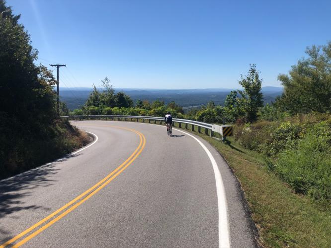
This 3.4 mile bike climb is located in TN, USA. The average gradient is 6.2% and there is a total elevation gain of 1,111 ft, finishing at 1,877 ft.
Use the profile tool, route map, and weather forecast to conquer this cycling climb.
Use the profile tool, route map, and weather forecast to conquer this cycling climb.
PLAN YOUR ROUTE
See more details and tools regarding this climb's grade via our interactive Profile Tool.
Information Not Available
If you have any information regarding this climb, we'd like to hear from you. Click the CONTRIBUTE button to share your thoughts with us.
Information Not Available
If you have any information regarding this climb, we'd like to hear from you. Click the CONTRIBUTE button to share your thoughts with us.
Before heading out on any cycling adventure check out our Things to Bring on a Cycling Trip and use our interactive check list to ensure you don't forget anything.
Information Not Available
If you have any information regarding this climb, we'd like to hear from you. Click the CONTRIBUTE button to share your thoughts with us.
ROUTE MAP
MEMBER RATING
CURRENT WEATHER
PJAMM TRIPS ADVENTURE STARTER BUNDLES
Check out PJAMM Adventure's prepackaged (self-guided) cycling trips. They will help you plan, document and conquer your next adventure.
NEARBY CLIMBS (0) RADIAL PROXIMITY
FROM No Climbs Found
MEMBER REVIEWS & COMMENTS
Let us know what you thought of this climb. Signup for our FREE membership to write a review or post a comment.
Already have an account?
LOG IN HERE
Bootsc
A fun shorter climb. Very peaceful in the morning. The canopy of trees give tons of shade in the hot summer. Only the less strenuous parts of the climb are unshaded. There are 2 or 3 spots to take in the view of the valley and the opposing ridge, if you're interested in stopping. Not a lot of traffic but I've found people in Tennessee are generally very considerate and give lots of room when passing. Make it a loop by riding to the end of Montlake Rd. and hanging a right on Mowbray Pike. Enjoy the decent but be careful of the pour road patches, sand/stone on the shoulder, and the hairpin that made me lose the rear tire for a sketchy moment before recovering. This is a great climb to stick in the middle of a long ride if you're ever riding through Soddy Daisy.