7.9
PDI
2.1 mi
DISTANCE
1,033 ft
GAINED
9.5 %
AVG. GRADE
FULL CLIMB STATS
INTRO
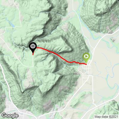
This 2.1 mile bike climb is located in TN, USA. The average gradient is 9.5% and there is a total elevation gain of 1,033 ft, finishing at 1,679 ft.
Use the profile tool, route map, and weather forecast to conquer this cycling climb.
Use the profile tool, route map, and weather forecast to conquer this cycling climb.
PLAN YOUR ROUTE
This climb averages 0%. The steepest quarter mile of this climb is 0%. NaN miles of the climb is at or above 10% grade. The gradient on this climb is broken down as follows:
See more details and tools regarding this climb's grade via our interactive Profile Tool.
See more details and tools regarding this climb's grade via our interactive Profile Tool.
Information Not Available
If you have any information regarding this climb, we'd like to hear from you. Click the CONTRIBUTE button to share your thoughts with us.
Information Not Available
If you have any information regarding this climb, we'd like to hear from you. Click the CONTRIBUTE button to share your thoughts with us.
Before heading out on any cycling adventure check out our Things to Bring on a Cycling Trip and use our interactive check list to ensure you don't forget anything.
Information Not Available
If you have any information regarding this climb, we'd like to hear from you. Click the CONTRIBUTE button to share your thoughts with us.
ROUTE MAP
MEMBER RATING
CURRENT WEATHER
PJAMM TRIPS ADVENTURE STARTER BUNDLES
Check out PJAMM Adventure's prepackaged (self-guided) cycling trips. They will help you plan, document and conquer your next adventure.
NEARBY CLIMBS (0) RADIAL PROXIMITY
FROM No Climbs Found
MEMBER REVIEWS & COMMENTS
Let us know what you thought of this climb. Signup for our FREE membership to write a review or post a comment.
Already have an account?
LOG IN HERE
JohnS
This would be a great short climb but the road is in awful condition. We parked at the base at the cave spring state park which was great logistics but the mountain road is rutted, rough and basically requires you to bounce your way up and ride your brakes hard back down because you can't go more than 10 mph without risk.
jsummers
One of the many short and steep climbs in this amazing area to ride a bike. Narrow road is under tree cover much of the way for shade. Multiple ways to get to the tops of the ridges in the area can keep you occupied for days.