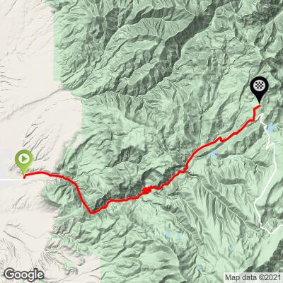
23.5
PDI
18 mi
DISTANCE
4,324 ft
GAINED
4.5 %
AVG. GRADE
FULL CLIMB STATS
Page Contributor(s): Ron Hawks, Las Vegas, Nevada, USA Bruce Hamilton/Stacy Topping, USA
INTRO
Highway 153 is ranked #77 on the US Top 100 list. The climb begins just east of Beaver, UT (a small town of about 3,000) and ends on Elk Meadows Drive at Eagle Point Ski Resort. If coming from Salt Lake City, this is the first of the three southern Utah Top 100 Climbs (37 miles north of #36 Highway 143 and 102 miles north of #75 Kolob Terrace) as we travel south from SLC.
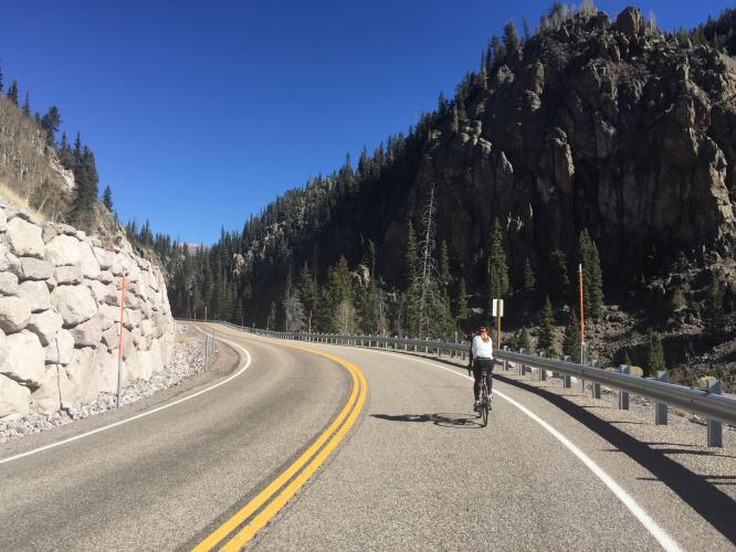
"The route up 153 to Elk Meadows is a solid climb to high altitude. The road heads up a drainage along a scenic creek over the bottom half of the climb. After a few scenic switchbacks the high mountains appear and you enter a small valley where the grade flattens. You soon pass the Elk Meadows ski area (right) where the grade increases..." (This quote is presented with the approval of John Summerson from his book, 50 Climbs (by Bike) in Utah, pg. 130.)
PLAN YOUR ROUTE
4.5% average grade (4.9% if descent is eliminated from the gradient formula). 51% of the climb is in the 0-5% gradient range, 37% is at 5-10% grade, and 6% is at 10-15%. The steepest quarter-mile is 11.6% and steepest mile 9.7%.
See more details and tools regarding this climb's grade via the “Profile Tool” button.
Roadway: Two lane highway in fair to good condition with minimal to no shoulder.
Traffic: Mild.
Parking: At the golf course parking lot on the left about 100 yards up from the start of the climb (Map; Street View).
Provisions: None on the way. There may be something available at the golf course near climb start, and there is a store and places to eat in Beaver a mile west of our start point.
Before heading out on any cycling adventure check out our Things to Bring on a Cycling Trip and use our interactive check list to ensure you don't forget anything.
This is one of three top 100 bike climbs on the way from Salt Lake City to Zion or Grand Canyon National Parks.
Use the “Routes in Area” button on the menu bar to see other bike climbs in this area.
ROUTE MAP
MEMBER RATING
CURRENT WEATHER
PJAMM TRIPS ADVENTURE STARTER BUNDLES
Check out PJAMM Adventure's prepackaged (self-guided) cycling trips. They will help you plan, document and conquer your next adventure.
NEARBY CLIMBS (0) RADIAL PROXIMITY
FROM No Climbs Found
MEMBER REVIEWS & COMMENTS
Let us know what you thought of this climb. Signup for our FREE membership to write a review or post a comment.
Already have an account?
LOG IN HERE
Skotscott
July 14, 2023
94° when I started the climb in Beaver then got cooler as I ascended. 80° at the top. First 17 miles are a gradual climb on a good road with areas of no shoulder and some shoulder. Light traffic and low speeds so felt safe. The final 3 miles are the hardest with increased grade and altitude. At the top, take a left up a road with new homes to reach 10,200ft. Continuing straight on the main road, you'll do a short decent then a gradual climb up to the summit sign showing 10,000ft. Great decent. A few places where falling rocks have damaged the road but easy to ride around. At mile 10, you can cross a bridge and do a short twisty climb up to a lake and campground with a cold water spigot.
trier1992
Really enjoyed this climb. The start is along a running stream and at a reasonable grade. The end is pretty tough and a very daunting task to finish with.
jsummers
153 is a big climb, long and to high altitude. Shallow initial section lets you get warmed up and then some switchbacks give it an alpine feel. Many different looks on this one and it finishes with double digit grade among big aspens.