9.6
PDI
8.3 mi
DISTANCE
2,007 ft
GAINED
4.5 %
AVG. GRADE
FULL CLIMB STATS
INTRO
This 8.3 mile bike climb is located in VA, USA. The average gradient is 4.5% and there is a total elevation gain of 2,007 ft, finishing at 4,875 ft.
Use the profile tool, route map, and weather forecast to conquer this cycling climb.
Use the profile tool, route map, and weather forecast to conquer this cycling climb.
PLAN YOUR ROUTE
This climb averages 0%. The steepest quarter mile of this climb is 0%. NaN miles of the climb is at or above 10% grade. The gradient on this climb is broken down as follows:
See more details and tools regarding this climb's grade via our interactive Profile Tool.
See more details and tools regarding this climb's grade via our interactive Profile Tool.
Information Not Available
If you have any information regarding this climb, we'd like to hear from you. Click the CONTRIBUTE button to share your thoughts with us.
Information Not Available
If you have any information regarding this climb, we'd like to hear from you. Click the CONTRIBUTE button to share your thoughts with us.
Before heading out on any cycling adventure check out our Things to Bring on a Cycling Trip and use our interactive check list to ensure you don't forget anything.
Information Not Available
If you have any information regarding this climb, we'd like to hear from you. Click the CONTRIBUTE button to share your thoughts with us.
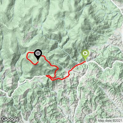
ROUTE MAP
MEMBER RATING
CURRENT WEATHER
PJAMM TRIPS ADVENTURE STARTER BUNDLES
Check out PJAMM Adventure's prepackaged (self-guided) cycling trips. They will help you plan, document and conquer your next adventure.
NEARBY CLIMBS (0) RADIAL PROXIMITY
FROM No Climbs Found
MEMBER REVIEWS & COMMENTS
Let us know what you thought of this climb. Signup for our FREE membership to write a review or post a comment.
Already have an account?
LOG IN HERE
Skotscott
June 19, 2023
Camped at Grayson Highlands SP. I've done this climb several times and it's a wonderful ride through Appalachian scenery. Here's my version : from campsite down to 58, to 725 and zig zag back onto 725 (grassy creek rd) to the end at hwy 16. Ride back up 725 to 58 (climbing) then take a left onto 748 to the end of the pavement then climb back up to 748 (challenging climb) to 58, then up Grayson Highlands rd, drop down to the picnic area (climb back up) then up to the top at the visitor's center.
34 miles, 4350ft gained. A wonderful ride through the countryside.