![File:Singapore Road Signs - Warning Sign - Other Dangers.svg ...]()
![File:Singapore Road Signs - Warning Sign - Other Dangers.svg ...]()
![File:Singapore Road Signs - Warning Sign - Other Dangers.svg ...]()
![File:Singapore Road Signs - Warning Sign - Other Dangers.svg ...]()
![File:Singapore Road Signs - Warning Sign - Other Dangers.svg ...]()
![File:Singapore Road Signs - Warning Sign - Other Dangers.svg ...]()
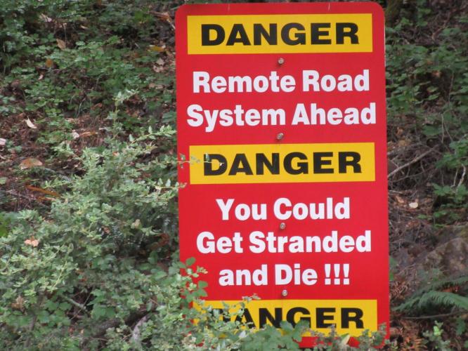
![Sign at Bear Camp West, Oregon, Climb Sign reads "Danger Remote Road System Ahead, Danger you could get stranded and die!!! Danger"]()
Cycling Bear Camp West, Oregon
Ride 16.5 miles gaining 4,624’ at 5.3% average grade.
See our US Top 10 Most Epic Bike Climbs page for more amazing and epic climbs.
![Beginning of Bear Camp West, Oregon, Climb Cyclist rides at beginning of climb near sign that says "Bear Camp Coastal Route Travel Beyond This Point Not Advised Nov 5 thru May 31]()
Climb start.
They don’t leave much doubt about the remote and risky nature of these climbs!
Cycling Bear Camp West is a Top 100 U.S. Bike Climb and that ranking is well deserved. The ascent is brutal and the descent one of the most difficult (dare we use the “T” word?? . . .Treacherous) we have ever encountered. We initially ascended from the east for the 20 miles to Bear Camp Overlook, then began the 16 mile descent to the Rogue River and beginning of the western ascent. The “roadway” has by our rough estimate six short gravel sections and several extremely slick mossy patches that can prove quite perilous to the unwary, particularly in damp and/or rainy conditions. The roadway is single lane, very narrow and windy.
![Cycling Bear Camp West Many warning signs along the climb, aerial drone photos show alpine coastal views]()
The Climb begins on the NF-23 (just east of the Rogue River) in an extremely remote section of southern Oregon at the "intersection" of Agness Road and NF-23, 30 miles along the Rogue River east of the Pacific Ocean and Gold Beach, OR.
![Cycling Bear Camp West Wide Roadway intersection at climb's start]()
Climb start.
![Cycling Bear Camp West Rural Road - "Road Sign" is just a spray painted "23" on roadway signifying Forest Road 23]()
This is a road sign in these parts - Forest Road 23.
However, what we lose on the rating scale for hazard-of-descent, we gain on the ascent – the term “Epic” was created to describe climbs such as Bear Camp West. For those with a profound sense of adventure who are not risk averse, this is a must-do climb. Caveat: the sign at the beginning of the eastern approach (photo) may be a bit of an exaggeration, but only by a slight margin – this is a climb that is best done with one or more other cyclists and SAG support. We have good views of the heavily wooded coastal mountains as we ascend up a very narrow roadway that is often bordered by a steep cliff on one side (of course there is no guard rail). The climb alone would warrant the trip at 16 miles, 6% average grade, gaining 4,600’ in that brief distance, and make this a Grade “A” HC category climb.
![Cycling Bear Camp West Views along the climb including alpine setting, wildflowers, sign for falling rock, snow lined roadway]()
Views along the route.
![Cycling Bear Camp West Bike with PJAMM Cycling jersey draped over it parked next to sign for Bear Camp Overlook, Siskiyou National Forest]()
Top of the climb.
Final note: It’s not easy to get to, but it’s worth the effort! It’s a Bucket List Climb.
![IMG_1730.JPG]()
Source: The Weather Channel and Wikipedia.

 We've partnered with Sherpa-Map.com to bring you the best route planning tool. With a PRO Membership you can use this climb as a reference when creating your route.


