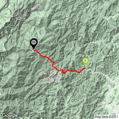
Bear Camp East Bike Climb - PJAMM Cycling

19.8
PDI
20.2 mi
DISTANCE
4,517 ft
GAINED
3.8 %
AVG. GRADE

FULL CLIMB STATS

INTRO

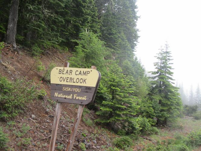
A very remote and interesting bike climb in the Rogue River-Siskiyou National Forest.

See more details and tools regarding this climb's grade via our interactive Profile Tool.
Information Not Available

If you have any information regarding this climb, we'd like to hear from you. Click the CONTRIBUTE button to share your thoughts with us.

Information Not Available

If you have any information regarding this climb, we'd like to hear from you. Click the CONTRIBUTE button to share your thoughts with us.

Before heading out on any cycling adventure check out our Things to Bring on a Cycling Trip and use our interactive check list to ensure you don't forget anything.
Information Not Available

If you have any information regarding this climb, we'd like to hear from you. Click the CONTRIBUTE button to share your thoughts with us.

ROUTE MAP

MEMBER RATING

Not Yet Rated
-
Road
-
Traffic
-
Scenery

CURRENT WEATHER

PJAMM TRIPS ADVENTURE STARTER BUNDLES

Check out PJAMM Adventure's prepackaged (self-guided) cycling trips. They will help you plan, document and conquer your next adventure.
ALL TRIPS
Browse all of our prepackaged trips and find your next adventure!
Crater Lake
United States (OR)
10 ROUTES
29 POIs
ROUTE STATS (TOTAL)
258.3
mi
DISTANCE
29,750
ft
ELEV. GAIN

NEARBY CLIMBS (0) RADIAL PROXIMITY

FROM
No Climbs Found

MEMBER REVIEWS & COMMENTS

Let us know what you thought of this climb. Signup for our FREE membership to write a review or post a comment.
Already have an account?

Apr 7, 2021
The east side of this road was in much better condition than the west side when I saw it. If you are considering riding the entire road, I suggest not doing it alone and doing some research beforehand.
ROUTE MAP
PROFILE TOOL
Route Data
S.G. (%)
hide
Segment Data
hide

Climb Profile Not Found
CLIMB SUMMARY

File:Singapore Road Signs - Warning Sign - Other Dangers.svg ... File:Singapore Road Signs - Warning Sign - Other Dangers.svg ...File:Singapore Road Signs - Warning Sign - Other Dangers.svg ...File:Singapore Road Signs - Warning Sign - Other Dangers.svg ...File:Singapore Road Signs - Warning Sign - Other Dangers.svg ...File:Singapore Road Signs - Warning Sign - Other Dangers.svg ...

Danger you could die.jpg

IMG_1656.JPG

They don’t leave much doubt about the remote and risky nature of these climbs!

​​ Wow!  Read and heed the sign (photo) – this is an all-time classic warning sign and is a bit appropriate as we barely finished this one, getting ourselves into a pickle with adverse weather towards the top of the climb (and then pushing on down and then back up the western Bear Camp ascent – when will we learn!). Beware that there are NO provisions and very little traffic and no civilization on this ultra-remote climb – well, that’s why it is EPIC!  The east side of Bear Camp is a tale of 3 climbs (a) the first 4 miles are at 3%, (b) the next 5 miles are at 8.2%, gaining 2,350’ and (c) the final 11 miles are back to 3% average grade.  We are surrounded by forest which borders the roadway most of the ascent, thus blocking distant views. There is a viewpoint at the end of the climb “Bear Camp Overlook” in fact!  However, we were there on a miserable rainy overcast day which drastically limited views from the upper section of the climb. The roadway surface is very rough and this is a single lane road.  There is very little traffic and the traffic we encountered was slow to react to us – we are certain drivers do not expect to see cyclists out there, so be very cautious. ​

IMG_1712.JPG   

Enter the National Forest at 13.4

Old sign - forest as of 2004 is the combined Rogue River-Siskiyou National Forest.

Established 2004; 1,723,179 acres.

 IMG_1730.JPG

It was miserable weather during our May, 2016 trip.

IMG_1730.JPG

Source:  The Weather Channel and Wikipedia.