Cloudcroft - Hwy 82 Bike Climb - PJAMM Cycling

7.9
FIETS
14.2 mi
DISTANCE
4,011 ft
GAINED
5.2 %
AVG. GRADE

FULL CLIMB STATS

Page Contributor(s): Dan Razum, Campbell, CA, USA; Henning Bommel, Germany;

INTRO

This climb is a rarity for Top 100 U.S. Climbs, as it travels from one town (La Luz, 2010 pop. 1,697) and ends in another town/village (Cloudcroft, 2013 pop. 697) 14.2 miles and 3,943' up the mountain. The climb enters Lincoln National Forest at mile one and stays there for the remainder of the climb.
Average grade is 5.2% with 4,000' gained in 14.2 miles.  45% of the climb is at 0-5% grade and 47% is at 5-10% grade.  The steepest quarter-mile is 9.9% and steepest mile 7%.  

See more details and tools regarding this climb's grade via the “Profile Tool” button.
Roadway:  Highway 82 is a two lane highway in good condition.  

Traffic:  Our experience - Moderate to moderately heavy - not for the traffic averse.  From Henning Bommel (Strava KOM 2020), "the area is awesome to ride the bike. Low traffic and nice caring people. You have to be careful with the altitude if you aren't used to it." 

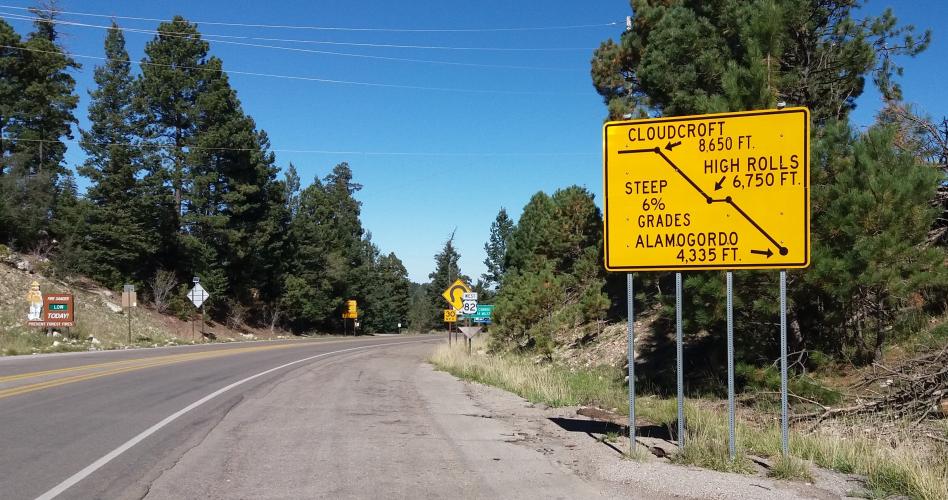
Tunnel:  There is a 100 yard tunnel at mile 5.3 so bring rear lights. 

Parking:  On the side of the road at climb start - Map; Street View
Provisions:  General store in High Roles at mile 6.5 and Cloudcroft on Highway 82 at the mall at the beginning of town. 

Weather and Gear
:  You finish this climb at 8,645', 4,000' above where you began so consult the PJAMM "Full Forecast" feature for the time you expect to arrive at the finish to assess what clothing to bring on your ride.
Before heading out on any cycling adventure check out our Things to Bring on a Cycling Trip and use our interactive check list to ensure you don't forget anything.
Information Not Available

If you have any information regarding this climb, we'd like to hear from you. Click the CONTRIBUTE button to share your thoughts with us.
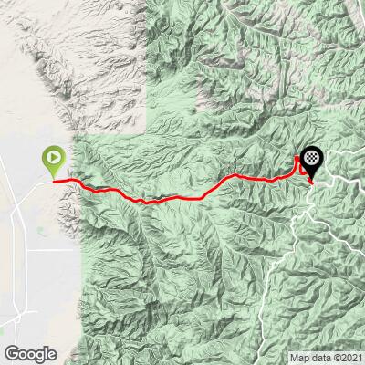
ROUTE MAP

MEMBER RATING

Difficulty: Challenging
3
Road
4
Traffic
3
Scenery

CURRENT WEATHER

PJAMM TRIPS ADVENTURE STARTER BUNDLES

Check out PJAMM Adventure's prepackaged (self-guided) cycling trips. They will help you plan, document and conquer your next adventure.
ALL TRIPS
Browse all of our prepackaged trips and find your next adventure!
The American Southwest
United States (AZ,NM,UT)
18 ROUTES
27 POIs
ROUTE STATS (TOTAL)
215.4
mi
DISTANCE
34,866
ft
ELEV. GAIN

NEARBY CLIMBS (0) RADIAL PROXIMITY

FROM
No Climbs Found

MEMBER REVIEWS & COMMENTS

Let us know what you thought of this climb. Signup for our FREE membership to write a review or post a comment.
Already have an account?

Apr 5, 2021
difficulty: Challenging
scenery: 3
traffic: 4
road: 3
Apr 5, 2021
scenery: 3
traffic: 4
road: 3
Cloudcroft is a big hill in an interesting and isolated section of New Mexico. The mostly steady grade lets you get into a rhythm. Seems to be a bit more traffic on its upper part and watch the tunnel just under half way up.
ROUTE MAP
PROFILE TOOL
Route Data
S.G. (%)
hide
Segment Data
hide

Climb Profile Not Found
CLIMB SUMMARY

"Another contender for the most difficult ascent in New Mexico, the west side of Cloudcroft along Route 54 is a solid route up to the high country, ending in the small mountain town of Cloudcroft. From a shallow start the grade soon gets more variable but is never steep. Near the top trees arrive for shade in places along with a bit more traffic and the summit is signed and obvious..." (This quote is presented with the approval of John Summerson, from his book, The Complete Guide to Climbing (by Bike), 2nd Edition, pg. 202.)

This climb is a rarity for Top 100 U.S. Climbs as it travels from one town (La Luz, population  1,697 in 2010)) and ends in another town/village (Cloudcroft, population 697 in 2013) 14.2  miles and 3,943' up the mountain.  The climb enters Lincoln National Forest at mile 1 and  stays there for the remainder of the climb.

   IMG_2234.JPG

Enter Lincoln National Forest at mile 1.

Established 1902 by Teddy Roosevelt; 1,103,897 acres.


Steepest ¼ mile begins at mile 5.1 (11.2%) and steepest mile at 4.3 (7.1%)

An excellent summary of this climb is found at Day 15 of Steve Garufi's Bike Across America 2011  which includes photos, a climb summary and this very important warning:  "And then I reached the tunnel.  Let me say up front: This is a tunnel for cyclists to be prepared for! I strongly recommend bicycle lights while in the tunnel, especially if you don't have the protection of a SAG wagon or friendly vehicle following directly behind you. In  retrospect, I didn't have lights. The length of the tunnel was about 0.2 miles, and I rode fast enough that I didn't have an encounter of a car trying to pass me. But if traffic is heavy, this would be a dangerous section for cyclists." We tracked the tunnel via satellite map image to miles 5.3 to 5.41 of the climb at 5.7% over that stretch so we are certain it felt like .2 miles to Steve as he hussled through that tunnel (those of you that have ridden Mt. Baldy know to fear the tunnel).  Steve and his crew created a Facebook page for this climb - Cyclists who've biked from Alamogordo.

There was a general store in High Rolls(mile 6.5) when Steve went through in 2011 - Day 15 Bike Across America.

Access to full Climb Summary requires a PJAMM Cycling PRO Membership!

It takes less than a minute to sign up & with your PRO membership you can:
  • Rate climbs, post comments and share your experiences on any of our climb pages
  • Create bucket lists of climbs & mark the dates you complete them
  • Weather data for all climbs - Start & Finish
  • Upload photos to your member page to customize your PJAMM Cycling experience
  • Utilize all of our interactive tools - Profile & Routes in Area
  • Download climb route .gpx files
LEARN MORE
SIGN UP

Already have an account? LOG IN HERE