Mesa Verde NP (Entrance to Park Point) Bike Climb - PJAMM CyclingMesa Verde NP (Entrance to Park Point) Bike Climb - PJAMM Cycling

8.3
PDI
10.6 mi
DISTANCE
1,970 ft
GAINED
2.6 %
AVG. GRADE

FULL CLIMB STATS

Page Contributor(s): Dan Razum, San Jose, California

INTRO

Tunnel at mile 4.6 - bring tail light.

PLAN YOUR ROUTE

We've partnered with Sherpa-Map.com to bring you the best route planning tool. With a PRO Membership you can use this climb as a reference when creating your route.

PROFILE CLICK IMAGE or BUTTON FOR INTERACTIVE TOOL

This climb averages 2.6%. The steepest quarter mile of this climb is 7.5% and steepest continuous mile is 6.2%. 0.04 miles of the climb is at or above 10% grade. The gradient on this climb is broken down as follows: 1.9 miles (17.6%) of descent; 5.1 miles (48.7%) at 0-5% grade; 3.5 miles (33.4%) at 5-10% grade; 0.04 miles (0.4%) at 10-15% grade;

See more details and tools regarding this climb's grade via our interactive Profile Tool.
Information Not Available

If you have any information regarding this climb, we'd like to hear from you. Click the CONTRIBUTE button to share your thoughts with us.

Information Not Available

If you have any information regarding this climb, we'd like to hear from you. Click the CONTRIBUTE button to share your thoughts with us.

Before heading out on any cycling adventure check out our Things to Bring on a Cycling Trip and use our interactive check list to ensure you don't forget anything.
Information Not Available

If you have any information regarding this climb, we'd like to hear from you. Click the CONTRIBUTE button to share your thoughts with us.

ROUTE MAP

MEMBER RATING

Not Yet Rated
-
Road
-
Traffic
-
Scenery

CURRENT WEATHER

PJAMM TRIPS ADVENTURE STARTER BUNDLES

Check out PJAMM Adventure's prepackaged (self-guided) cycling trips. They will help you plan, document and conquer your next adventure.
ALL TRIPS
Browse all of our prepackaged trips and find your next adventure!
Colorado: Front Range
United States (CO)
20 ROUTES
46 POIs
ROUTE STATS (TOTAL)
563.5
mi
DISTANCE
73,545
ft
ELEV. GAIN
RMNP: Trail Ridge Road
United States (CO)
13 ROUTES
33 POIs
ROUTE STATS (TOTAL)
258.2
mi
DISTANCE
25,530
ft
ELEV. GAIN

NEARBY CLIMBS (0) RADIAL PROXIMITY

FROM
No Climbs Found

MEMBER REVIEWS & COMMENTS

Let us know what you thought of this climb. Signup for our FREE membership to write a review or post a comment.
Already have an account?
ROUTE MAP
PROFILE TOOL

Mesa Verde NP (Entrance to Park Point)

STREET VIEWS
Explore the climbing route via Google Street Views.
IMAGES
View epic images taken along the climbing route.
SEGMENT
Select a portion of the route to retrieve climb & profile data for that segment.
GRADIENT
See where the steepest portions of the climb are located by gradient group.
Gradient
30%
20%
10%
0%
Route Data
S.G. (%)
hide

Steepest Gradient (%)

7.5
0.25 mi
7.1
0.5 mi
6.2
1 mi
5.5
2.5 mi
3.1
5 mi

Click on above gradient to display on profile.

Drag Knobs to Select Segment

Route Data
S.G. (%)
hide

Steepest Gradient (%)

7.5
0.25 mi
7.1
0.5 mi
6.2
1 mi
5.5
2.5 mi
3.1
5 mi

Click on above gradient to display on profile.

Segment Data
hide
CLIMB SUMMARY

Cycling Mesa Verde NP from Entrance to Park Point

Ride 10 miles gaining 1,970’ at 2.6% average grade (5% climb only).

On average, Mesa Verde National Park near Cortez Colorado has between 500,000 to 600,000 with a high of 742,080 in 1992 and low of 445,400 in 1974.  By contrast, Smoky Mountain NP, the most visited park, had 14,000,000 visitors in 2021 followed by Zion far below with 5,000,000. The park was established in 1906 by President Theodore Roosevelt and is a Unesco World Heritage site:

“A great concentration of ancestral Pueblo Indian dwellings, built from the 6th to the 12th century, can be found on the Mesa Verde plateau in south-west Colorado at an altitude of more than 2,600 m. Some 4,400 sites have been recorded, including villages built on the Mesa top. There are also imposing cliff dwellings, built of stone and comprising more than 100 rooms.”  Unesco.

Climb summary by PJAMM ambassador Dan Razum, San Jose, California.

The climb starts just after the Visitor Center, right off of highway 160.  There is plenty of free parking at the Visitor Center, you can just park and ride from there.  The Park Entrance Station is about a half mile (uphill) from the Visitor Center and there is a $15 entrance fee for cyclists, as of August 2022. (or you can use the National Parks Interagency pass, if you have one) Please note that they do not accept cash, credit card only.  If you forgot your credit card in your car at the Visitor Center then you can add on an extra half mile to the climb (don't ask how we can be so sure about that...)

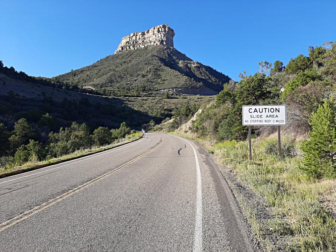
After the Entrance Station it is about 3 miles of climbing to Mancos Overlook.  This part of the climb is very scenic, with ever expanding views as we scale the mountain.  The road is in good condition, the air is fresh and the mountain looming over us makes it feel epic.

After Mancos Overlook there is a downhill section, and we pass by Morfield Campground.  At the  bottom of the downhill there is a tunnel, the only one on the climb.  The tunnel is straight and not too long, but it's still advisable to have a rear light.  After the tunnel we start  climbing again, the scenery isn't as grand as before.  We can usually see the road carved in

the mountain in front and above us, so it's always pretty clear where we are headed.  We pass another overlook, Montezuma Overlook, but the views aren't as epic as from Mancos Overlook. There are still some nice views scattered along the way, though.  Eventually we come to  another short downhill section, which is a nice break before the final section of climbing.

The final half mile is a small road to the Park Point fire lookout.  The road goes to a parking lot and at the end of the parking lot is a small foot trail a couple hundred yards long. Ride up the trail and enjoy the awesome views in all directions.

Finish the climb at 8,572’

Access to full Climb Summary requires a PJAMM Cycling PRO Membership!

It takes less than a minute to sign up & with your PRO membership you can:
  • Rate climbs, post comments and share your experiences on any of our climb pages
  • Create bucket lists of climbs & mark the dates you complete them
  • Weather data for all climbs - Start & Finish
  • Upload photos to your member page to customize your PJAMM Cycling experience
  • Utilize all of our interactive tools - Profile & Routes in Area
  • Download climb route .gpx files

TRY PRO FREE FOR 7 DAYS

LEARN MORE
SIGN UP

Already have an account? LOG IN HERE

BESbswy