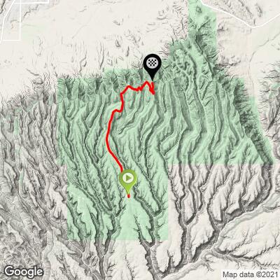
Mesa Verde NP - Chapin Mesa to Park Point Bike Climb - PJAMM Cycling

2.7
FIETS
10.1 mi
DISTANCE
1,641 ft
GAINED
2.6 %
AVG. GRADE

FULL CLIMB STATS

Page Contributor(s): Dan Razum, San Jose, California

INTRO

This 10.1 mile bike climb is located in CO, USA. The average gradient is 2.6% and there is a total elevation gain of 1,641 ft, finishing at 8,459 ft.

Use the profile tool, route map, and weather forecast to conquer this cycling climb.

See more details and tools regarding this climb's grade via our interactive Profile Tool.
Information Not Available

If you have any information regarding this climb, we'd like to hear from you. Click the CONTRIBUTE button to share your thoughts with us.

Information Not Available

If you have any information regarding this climb, we'd like to hear from you. Click the CONTRIBUTE button to share your thoughts with us.

Before heading out on any cycling adventure check out our Things to Bring on a Cycling Trip and use our interactive check list to ensure you don't forget anything.
Information Not Available

If you have any information regarding this climb, we'd like to hear from you. Click the CONTRIBUTE button to share your thoughts with us.

ROUTE MAP

MEMBER RATING

Difficulty: Challenging
5
Road
3
Traffic
5
Scenery

CURRENT WEATHER

PJAMM TRIPS ADVENTURE STARTER BUNDLES

Check out PJAMM Adventure's prepackaged (self-guided) cycling trips. They will help you plan, document and conquer your next adventure.
ALL TRIPS
Browse all of our prepackaged trips and find your next adventure!
Colorado: Front Range
United States (CO)
20 ROUTES
46 POIs
ROUTE STATS (TOTAL)
563.5
mi
DISTANCE
73,545
ft
ELEV. GAIN
RMNP: Trail Ridge Road
United States (CO)
13 ROUTES
33 POIs
ROUTE STATS (TOTAL)
258.2
mi
DISTANCE
25,530
ft
ELEV. GAIN

NEARBY CLIMBS (0) RADIAL PROXIMITY

FROM
No Climbs Found

MEMBER REVIEWS & COMMENTS

Let us know what you thought of this climb. Signup for our FREE membership to write a review or post a comment.
Already have an account?

May 12, 2021
difficulty: Challenging
scenery: 5
traffic: 3
road: 5
May 12, 2021
scenery: 5
traffic: 3
road: 5
The traffic depends on the time of year. I did it in May and the traffic was fine. This is a very exposed climb. It looks much more difficult then it is, as you can see the road laid in along the mesa and the switch backs look daunting. The climbs are actually pretty easy. My low gear was a 36/28 and I never longed for an easier gear. I made it from the park entrance to the high point in 1:08 minutes. The views are spectacular. But your experience is weather dependent. After high point, I road the entire length of the main road. My total distance was 43 miles. Riding to High Point and back is 20 miles. The winds kicked up on my return to the entrance, making the descent a bit dangerous. It took me 6.22 seconds to descend the final 2.5 miles which is actually pretty slow compared to those who descend in good weather.
ROUTE MAP
PROFILE TOOL
Route Data
S.G. (%)
hide
Segment Data
hide

Climb Profile Not Found
CLIMB SUMMARY

Cycling Mesa Verde NP from Entrance to Park Point

Ride 10 miles gaining 1,970’ at 2.6% average grade (5% climb only).

On average, Mesa Verde National Park near Cortez Colorado has between 500,000 to 600,000 with a high of 742,080 in 1992 and low of 445,400 in 1974.  By contrast, Smoky Mountain NP, the most visited park, had 14,000,000 visitors in 2021 followed by Zion far below with 5,000,000. The park was established in 1906 by President Theodore Roosevelt and is a Unesco World Heritage site:

“A great concentration of ancestral Pueblo Indian dwellings, built from the 6th to the 12th century, can be found on the Mesa Verde plateau in south-west Colorado at an altitude of more than 2,600 m. Some 4,400 sites have been recorded, including villages built on the Mesa top. There are also imposing cliff dwellings, built of stone and comprising more than 100 rooms.”  Unesco.

Climb summary by PJAMM ambassador Dan Razum, San Jose, California.

The climb starts at the end of the parking lot near the museum.  The Spruce Tree House cliff dwelling is nearby and worth a quick look before starting the climb.  There used to be a  walking path to the Spruce Tree House but it has been closed for several years, so we can only look across the canyon at it. It is nice scenery to start the climb.

Overall the climb is pretty mellow, never too steep. The first 5 miles up to Far View are along the top of the mesa, with no scenic views.  We pass through an area burned by a forest fire in 2002 and there is little sign of recovery, 20 years later.  It makes us appreciate the destructive nature of fires and the contrast between the burned and non-burned areas is stark.

There is a cafeteria at Far View Terrace, which is a good place to take a short break and refuel, especially when riding the entire Mesa Verde loop from the park entrance.

After Far View there is a downhill section and then we continue climbing for a couple of miles. There are some views along the way, but not super scenic.  We then come to another short downhill section before the last section of climbing.  The final half mile is on a cutoff road to Park Point, which ends at a parking lot.  At the far end of the parking lot is a small trail

leading to the summit.  The trail is a little steeper than the rest of the climb, but not too bad and it is short.  At the top there is a fire tower and two view areas with scenic views of the surrounding terrain in all directions.

Road Condition:  The road is in good condition throughout.  There can be a moderate amount of traffic, but the cars were all courteous and we felt safe.  The road is exposed the entire way and even if it is not too hot the sun can still be strong.