Left Hand Canyon - Super James Bike Climb - PJAMM Cycling

5.6
FIETS
11.9 mi
DISTANCE
2,881 ft
GAINED
4.6 %
AVG. GRADE

FULL CLIMB STATS

Page Contributor(s): Scott Herrin, Boulder, CO; Kevin Eggleston, Boulder, CO

INTRO

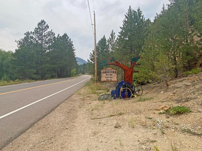
This is a very popular Boulder area climb up to and past the cycling-friendly Jamestown.  The first part of the climb from the intersection of Hwy 36 and Left Hand Canyon to Jamestown is a great warm up at 3% average grade for 8.3 miles. The final 3.5 miles however is at 8.3% and quite the challenge. 

See more details and tools regarding this climb's grade via our interactive Profile Tool.
Information Not Available

If you have any information regarding this climb, we'd like to hear from you. Click the CONTRIBUTE button to share your thoughts with us.

Information Not Available

If you have any information regarding this climb, we'd like to hear from you. Click the CONTRIBUTE button to share your thoughts with us.

Before heading out on any cycling adventure check out our Things to Bring on a Cycling Trip and use our interactive check list to ensure you don't forget anything.
This is one of the great climbs in the Boulder area (PJAMM Boulder Climb Area page) - we stay in Boulder with its many hotel options when we are cycling this and other area bike climbs. For longer stays you can look to rent a home or condo in the area.

Use the Routes in Area tool to see other bike climbs in this area. 

ROUTE MAP

MEMBER RATING

Not Yet Rated
-
Road
-
Traffic
-
Scenery

CURRENT WEATHER

PJAMM TRIPS ADVENTURE STARTER BUNDLES

Check out PJAMM Adventure's prepackaged (self-guided) cycling trips. They will help you plan, document and conquer your next adventure.
ALL TRIPS
Browse all of our prepackaged trips and find your next adventure!
Colorado: Front Range
United States (CO)
20 ROUTES
46 POIs
ROUTE STATS (TOTAL)
563.5
mi
DISTANCE
73,545
ft
ELEV. GAIN
RMNP: Trail Ridge Road
United States (CO)
13 ROUTES
33 POIs
ROUTE STATS (TOTAL)
258.2
mi
DISTANCE
25,530
ft
ELEV. GAIN

NEARBY CLIMBS (0) RADIAL PROXIMITY

FROM
No Climbs Found

MEMBER REVIEWS & COMMENTS

Let us know what you thought of this climb. Signup for our FREE membership to write a review or post a comment.
Already have an account?
ROUTE MAP
PROFILE TOOL
Route Data
S.G. (%)
hide
Segment Data
hide

Climb Profile Not Found
CLIMB SUMMARY

Cycling Left Hand Canyon to Brainard Lake via Jamestown

Ride 23.6 miles gaining 5,222’ at 3.8% average grade.

This is a long but generally mild climb, although you will be tested for a mile near the half-way point with a mile 10.4% segment beginning at mile 10.6 and 2.5 miles at 9.4% from miles 9.2-11.7.  There are 2 sets of multiple short descent segments from miles 12-15 and 22-23.

The climb begins by riding west on Lefthand Canyon Drive from Hwy 36

We ride along Left Hand Canyon Creek the first 5 miles and then Little James Creek for another 5 or so.

Enter the National Forest at mile 3.5

We pass through historic Jamestown at mile 8.

Photo:  westernmninghistory.com

Photo:  westernmninghistory.com

Turn onto Peak to Peak Highway at mile 14.7 and Brainard Lake Road at mil 19.4

Finish at Brainard Lake.

The roadway is in great shape and traffic fairly mild along this climb.  There is a 1 ½ mile gravel section after Jamestown just before Peak to Peak Highway, but it is manageable on a road bike, particularly with 28mm and above tires. From Jamestown, it’s ~4.5 miles paved and then ~1.5 unpaved to P2P. Unpaved not ideal on 23mm road tires.

2.1 miles of gravel/dirt at 1.5% beginning at mile 12.5 and continuing to Peak to Peak Hwy

Access to full Climb Summary requires a PJAMM Cycling PRO Membership!

It takes less than a minute to sign up & with your PRO membership you can:
  • Rate climbs, post comments and share your experiences on any of our climb pages
  • Create bucket lists of climbs & mark the dates you complete them
  • Weather data for all climbs - Start & Finish
  • Upload photos to your member page to customize your PJAMM Cycling experience
  • Utilize all of our interactive tools - Profile & Routes in Area
  • Download climb route .gpx files
LEARN MORE
SIGN UP

Already have an account? LOG IN HERE