Cycling the Tail of the Dragon in reverse (The Head of the Dragon?)
Ride 11 miles gaining 639’ (descending 1,671’) at -1.8% average grade.
First and foremost: DON’T DO IT. This is an extremely dangerous road. I offer this summary primarily as a fun story about a ride that no one should do on a bike. However, as a secondary purpose, I write to advise you how to do this ride as safely as possible if you do choose to do it.
This road is so popular with motorcyclists because it has so many turns (318) and no driveways -- an uninterrupted ride for 11 full miles.
Please view this video before you even think about doing this ride on a bike. Imagine if you were on your bike on a tight turn when this guy (a pro), or even worse, a wanna-be amateur, came up behind you. Nuff said . . . YouTube - US129 Dragon Slayer.

Tail of the Dragon shop 10 miles from start at junction of Routes 72 and 129.
I stopped at the Market and the last gas station/place for provisions before the Tail of the Dragon start. I struck up a conversation with a long-time TofD motorcyclist who was not very pleasant at the beginning of our chat. He had an obvious bias against cyclists, “you guys don’t pay taxes to use the road,” seemed to be the primary objection. He also assumed (because in the hundreds of times he’d ridden the TofD, he said he’d never encountered a bicyclist) that it would be extremely dangerous to ride the bike on this route because of all the blind curves. Note -- while doing the ride, both out and back, I didn’t have a sense of danger on curves, other than vehicles and motorcyclists screaming around them. Gary and I parted with him wishing me luck and reminding me that I was taking my life into my own hands.

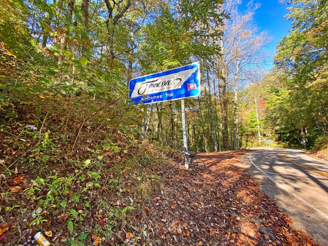
Start of the climb from the North Carolina side.
As noted, you should not do this ride; it is not safe. However, from some I spoke with milling about the start, it seems like the best time to ride is the time the real racing is not happening. As I was told, the “serious” drivers/riders come out before 9 a.m. and after 5 p.m. for a “clean run.” I did the ride on a late afternoon during the middle of the week and felt oddly safe. There were not a lot of racers and there was a lot of normal traffic (puttering Harley Davidson riders, a few RV’s, recreational vehicles, and the like). On the return trip where there is much more descending, I was able to keep up with slower moving traffic for a mile or two at a time.

![]()
One step ahead of the Grim Reaper . . . 😟😟
Dangerous Roads writes of this road:
“With 318 curves in 11 miles, it's America's number one motorcycle and sports car road. Deals Gap, also known as Tail of the Dragon, is a portion of U.S. Route 129 in Blount County, Tennessee, situated in a gap in Swain County, North Carolina, United States. It's heralded as one of the most scenic drives in USA.
The road still remains an adrenaline-pumping journey. With hundreds of blind curves, long blind crests, and high degrees of camber, this claustrophobic scenic forest road presents plenty of opportunities to leave the pavement both laterally, and longitudinally, and will provide a challenge for even the most seasoned sim veterans. The 11-mile stretch of the Dragon in Tennessee is said to have 318 curves. Some of the Dragon's sharpest curves have names like Copperhead Corner, Hog Pen Bend, Wheelie Hell, Shade Tree Corner, Mud Corner, Sunset Corner, Gravity Cavity, Beginner's End, and Brake or Bust Bend. The road earned its name from its curves being said to resemble a dragon's tail. While you're there, be sure to visit the Tree of Shame, where crashed motorcycle bits adorn the tree and dangle from its branches as a reminder of the road's dangers. The road is certainly breathtaking and it has a fearsome reputation,” (Dangerous Roads - Tail of the Dragon).

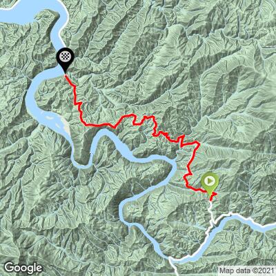
My Garmin for the ride out (left) and ride back (right).
There is much more descending on the ride back.