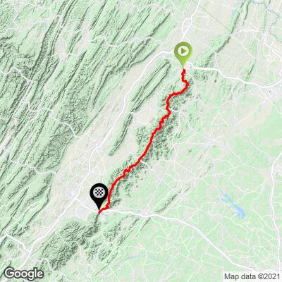
Skyline Drive - Shenendoah NP Bike Climb - PJAMM Cycling

0.7
FIETS
104.9 mi
DISTANCE
11,357 ft
GAINED
0.2 %
AVG. GRADE

FULL CLIMB STATS

Page Contributor(s): Craig Arcuri, Johnstown, PA, USA

INTRO

This 104.9 mile bike climb is located in VA, USA. The average gradient is 0.2% and there is a total elevation gain of 11,357 ft, finishing at 3,815 ft.

Use the profile tool, route map, and weather forecast to conquer this cycling climb.

See more details and tools regarding this climb's grade via our interactive Profile Tool.
Information Not Available

If you have any information regarding this climb, we'd like to hear from you. Click the CONTRIBUTE button to share your thoughts with us.

Information Not Available

If you have any information regarding this climb, we'd like to hear from you. Click the CONTRIBUTE button to share your thoughts with us.

Before heading out on any cycling adventure check out our Things to Bring on a Cycling Trip and use our interactive check list to ensure you don't forget anything.
Information Not Available

If you have any information regarding this climb, we'd like to hear from you. Click the CONTRIBUTE button to share your thoughts with us.

ROUTE MAP

MEMBER RATING

Difficulty: Extreme
5
Road
5
Traffic
4
Scenery

CURRENT WEATHER

PJAMM TRIPS ADVENTURE STARTER BUNDLES

Check out PJAMM Adventure's prepackaged (self-guided) cycling trips. They will help you plan, document and conquer your next adventure.
ALL TRIPS
Browse all of our prepackaged trips and find your next adventure!
Smoky Mountain National Park
United States (NC,TN)
17 ROUTES
31 POIs
ROUTE STATS (TOTAL)
181.8
mi
DISTANCE
34,253
ft
ELEV. GAIN
The Blue Ridge Parkway (North)
United States (NC,TN,VA)
38 ROUTES
70 POIs
ROUTE STATS (TOTAL)
716.5
mi
DISTANCE
75,697
ft
ELEV. GAIN
The Blue Ridge Parkway (South)
United States (NC,TN,VA)
30 ROUTES
63 POIs
ROUTE STATS (TOTAL)
690.7
mi
DISTANCE
74,180
ft
ELEV. GAIN

NEARBY CLIMBS (0) RADIAL PROXIMITY

FROM
No Climbs Found

MEMBER REVIEWS & COMMENTS

Let us know what you thought of this climb. Signup for our FREE membership to write a review or post a comment.
Already have an account?

Sep 30, 2021
difficulty: Extreme
scenery: 4
traffic: 5
road: 5
Sep 30, 2021
scenery: 4
traffic: 5
road: 5
I rode the length of Skyline on September 24, 2021, the hard way north to south. This is a challenge century! Always up or down, no actual flat area. Max sustained grades around 7% but it all adds up. Traffic on Skyline is seasonal and regional; much more in the summer and early fall as day-hikers and sightseers are out. The road is only accessible at mile 0, 32, 63, and 105. The middle 1/3 is the busiest due to the attractions along it. I've ridden a lot of Skyline and its partner BRP to the south and traffic is usually very respectful. Road condition in 2021 was an 11/10, the smoothest 105 miles you will ever ride. Scenery is beautiful but consistent - big valley & mountain ridge views. 85% of this road is totally shaded, so while that's good for hot days it can feel cold in marginal temps. Shoulder seasons will see 35 degree swings on time of day and elevation so be ready. My wife drove support but can be (barely) done with available water. Bucket list to ride this in one day!
ROUTE MAP
PROFILE TOOL
Route Data
S.G. (%)
hide
Segment Data
hide

Climb Profile Not Found
CLIMB SUMMARY

Cycling Skyline Drive, Virginia - NPS sign for Shenandoah National Park on the Skyline Drive

Cycling Skyline Drive through Shenandoah National Park, Virginia

Ride 104.9 miles gaining 11,253’

This is a magnificent bike ride that is one of the Big Three in the southeast:  

  • Skyline Drive/Shenandoah National Park (Virginia; 105 miles)
  • Blue Ridge Parkway (Virginia/North Carolina; 469 miles; connects Shenandoah and the Great Smoky Mountain National Parks)
  • Cherohala Skyway (Tennessee/North Carolina; 43 miles).

Cycling Skyline Drive, Virginia - map showing Skyline Drive, through Shenandoah National Park

The ride is along a ridgeline and entirely within Shenandoah National Park.

Shenandoah National Park was established in 1935, is made up of 199,173 acres, and hosts around 1.2 million visitors a year.  There is the standard national park entrance fee of $15 to ride on Skyline Drive through the park (nps.gov), or free with your lifetime over 62 America the Beautiful National Parks Lifetime Pass (like yours truly 👍👍)

There are two visitor centers on our route:

Cycling Skyline Drive, Virginia - NPS sign for Dickey Ridge Visitor Center

Dickey Ridge Visitor Center -- mile 4.5.

Photo:  Skyline Drive Overlooks

Harry F. Byrd Visitor Center -- mile 51.

Photo:  Skyline Drive Overlooks

Thanks to Craig Arcuri of Johnstown, Pennsylvania for the photos he took along his 105 mile trek through the park on October 19-20, 2020.

Cycling Skyline Drive, Virginia - photo collage, fall foliage throughout the park, PJAMM Cycling logo in corner

Access to full Climb Summary requires a PJAMM Cycling PRO Membership!

It takes less than a minute to sign up & with your PRO membership you can:
  • Rate climbs, post comments and share your experiences on any of our climb pages
  • Create bucket lists of climbs & mark the dates you complete them
  • Weather data for all climbs - Start & Finish
  • Upload photos to your member page to customize your PJAMM Cycling experience
  • Utilize all of our interactive tools - Profile & Routes in Area
  • Download climb route .gpx files
LEARN MORE
SIGN UP

Already have an account? LOG IN HERE