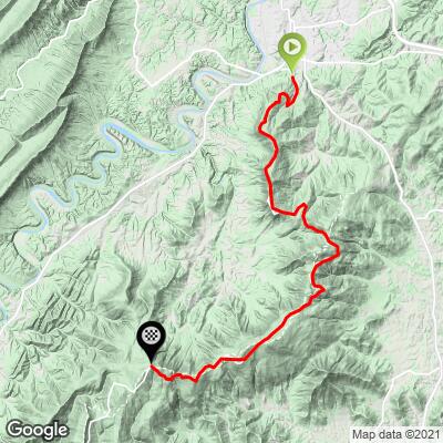
14.2
PDI
20.4 mi
DISTANCE
3,853 ft
GAINED
2.6 %
AVG. GRADE
FULL CLIMB STATS
INTRO
This 20.4 mile bike climb is located in VA, USA. The average gradient is 2.6% and there is a total elevation gain of 3,853 ft, finishing at 3,192 ft.
Use the profile tool, route map, and weather forecast to conquer this cycling climb.
Use the profile tool, route map, and weather forecast to conquer this cycling climb.
PLAN YOUR ROUTE
See more details and tools regarding this climb's grade via our interactive Profile Tool.
Information Not Available
If you have any information regarding this climb, we'd like to hear from you. Click the CONTRIBUTE button to share your thoughts with us.
Information Not Available
If you have any information regarding this climb, we'd like to hear from you. Click the CONTRIBUTE button to share your thoughts with us.
Before heading out on any cycling adventure check out our Things to Bring on a Cycling Trip and use our interactive check list to ensure you don't forget anything.
Information Not Available
If you have any information regarding this climb, we'd like to hear from you. Click the CONTRIBUTE button to share your thoughts with us.
ROUTE MAP
MEMBER RATING
CURRENT WEATHER
PJAMM TRIPS ADVENTURE STARTER BUNDLES
Check out PJAMM Adventure's prepackaged (self-guided) cycling trips. They will help you plan, document and conquer your next adventure.
NEARBY CLIMBS (0) RADIAL PROXIMITY
FROM No Climbs Found
MEMBER REVIEWS & COMMENTS
Let us know what you thought of this climb. Signup for our FREE membership to write a review or post a comment.
Already have an account?
LOG IN HERE
mbrothers
Note that I rated the traffic based on time of year.
Did this climb Friday evening, 11/17/2023. If you time it right, you will pass more wildlife than cars, and even then the cars are quite pleasant. You can park right after you turn onto skyline drive at the hiking trail to avoid any road traffic. Visitors center is ~4 miles up the road in case you need to use restrooms, etc.
It really is a combination of climbs versus a single climb, with multiple 600-1200 feet per effort separated by a fast downhill/plateau and most of the gradients sitting right around 6%.
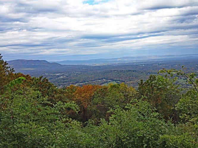
Scenic overviews on both sides on the way up.
Pavement is silky smooth and without potholes. No problems descending even after dark.
DrBullet
Considering the elevation gain, this does not feel like a very arduous climb. The gradient is moderate and consistent. The scenery is beautiful despite lacking the "drama" of more alpine climbs. Spring and summer provide lush green foliage and the fall provides spectacular colors. Beware of peak traffic during "peak leaf" season...it can be a challenge to even get to a nearby starting point at the weekend and traffic on Skyline drive can be almost bumper to bumper. There are many lookouts across both sides of the ridge but limited places to get water, so plan ahead.