

24.1
PDI
13.7 mi
DISTANCE
4,093 ft
GAINED
5.6 %
AVG. GRADE
FULL CLIMB STATS
INTRO
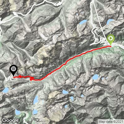
Nufenenpass - Passo della Novena in Italian - links Ticino's Val Bedretto with the Goms valley of upper Valais, and at 2478 m (8,130 ft) it is the highest paved pass road entirely inside Switzerland, second only to the border-straddling Umbrail. This is the eastern, Ticino approach from Airolo: 22.1 km (13.7 mi) gaining 1248 m (4,093 ft) at a 5.6% average.
It's a climb of two halves. The first 8 km (5.0 mi) are a gentle 2.8% drift up the Val Bedretto, a remote, wide alpine valley whose villages shelter behind massive stone avalanche wedges - Bedretto itself was almost wiped out by an avalanche in 1863. Beyond All'Acqua the valley closes in and the real climbing starts: the last 14 km (8.8 mi) average around 7%, with long stretches at 8-9% through a series of hairpins above the tree line to the windswept summit, where the Gries wind farm, the highest in Europe, stands just beyond the pass.
The road is young by Alpine standards - the crossing into the Val Bedretto was only completed in 1969, when a dam-access road below the Gries Glacier was extended over the top. It is seasonal: in 2026 the pass reopened on 29 May, and it typically closes again in late October or November. Summer weekends bring motorcycles, but traffic is far lighter than on the neighboring Gotthard.
PLAN YOUR ROUTE
 We've partnered with Sherpa-Map.com to bring you the best route planning tool. With a PRO Membership you can use this climb as a reference when creating your route.
 Nufenenpass from Airolo covers 22.1 km (13.7 mi) and gains 1248 m (4,093 ft) at a 5.6% average, finishing at the 2478 m (8,130 ft) pass.
Km 0-8: 8 km (5.0 mi) at just 2.8% up the Val Bedretto - a long warm-up on a gentle valley road.
Km 8-22.1: the climb proper, 14.1 km (8.8 mi) averaging roughly 7%, with sustained stretches of 8-9% on the upper hairpins.
Km 8-22.1: the climb proper, 14.1 km (8.8 mi) averaging roughly 7%, with sustained stretches of 8-9% on the upper hairpins.
The steepest kilometer averages 9.5% and the steepest 2 km average 8.8%. The upper half is fully exposed above the tree line, so wind can have a real effect on how hard the finale feels.
Roadway: Paved throughout and generally in good condition, with a wide, well-engineered upper section dating from the late 1960s. The pass closes in winter; on the Ticino side the road stays open year-round as far as All'Acqua, and the section above reopened for 2026 on 29 May. It typically closes again in late October or November - check current pass status before an early- or late-season ride.
Traffic: Light to moderate. The Val Bedretto is effectively a dead end for much of the year, so traffic is mostly local until the pass opens. In summer, weekends bring motorcyclists and touring cars crossing between Ticino and Valais, but volumes are well below the nearby Gotthard. Weekday mornings are the quietest.
Parking: Airolo is a stop on the Gotthard rail line, so arriving by train is the easiest option - construction work has cut the P+Rail lot at Airolo station to just 15 spaces from March 2026 through the end of 2027, so don't count on finding a space there. The climb starts at the western end of town, where Via Fontana heads into the Val Bedretto. For a shorter ride focused on the steep upper half, All'Acqua - about 10 km (6.2 mi) up the valley, where the gentle section ends - makes an alternate starting point.
Gear: Grades rarely top 9%, so standard compact gearing works, but you finish at 2478 m (8,130 ft), roughly 1200 m above Airolo, where it is noticeably colder and often windy. Arm warmers, a wind jacket and full-finger gloves for the descent are worth carrying even in midsummer.
Provisions: Stock up in Airolo, which has supermarkets and bakeries. Ristorante All'Acqua, just before the steep climbing begins, is the last stop in the valley, and in season there is a restaurant and kiosk at the pass itself.
Before heading out on any cycling adventure check out our Things to Bring on a Cycling Trip and use our interactive check list to ensure you don't forget anything.
Airolo is the Ticino gateway to the Gotthard and a practical base: it sits on the Gotthard rail line, and the Nufenen, the Gotthard (including its famous cobbled Tremola road) and the long descent down the Leventina are all on its doorstep. Near the San Gottardo cable car station, the Caseificio del Gottardo is a working show dairy where you can watch local cheese being made through glass walls, then eat fondue or raclette in its restaurant - an easy recovery meal after the descent.
On the way back down, the Val Bedretto's villages are worth a slow look: the stone avalanche wedges built on the uphill side of the houses and churches are a striking reminder of how harsh winters are here.
Linking the Nufenen with the Furka and Gotthard makes a classic big loop - see other climbs nearby, or build a custom route from here, with our Routes in the Area tool.
ROUTE MAP
MEMBER RATING
CURRENT WEATHER
PJAMM TRIPS ADVENTURE STARTER BUNDLES
Check out PJAMM Adventure's prepackaged (self-guided) cycling trips. They will help you plan, document and conquer your next adventure.
NEARBY CLIMBS (0) RADIAL PROXIMITY
FROM No Climbs Found
MEMBER REVIEWS & COMMENTS
Let us know what you thought of this climb. Signup for our FREE membership to write a review or post a comment.
Already have an account?
LOG IN HERE
