![]()
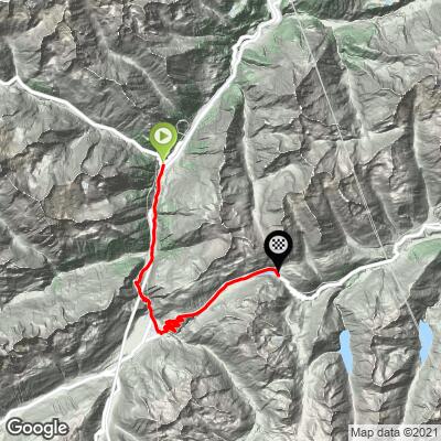
Cycling Oberalppass from the north
Ride 22 kilometers gaining 1,152 meters at 5.2% average grade.
![]()
![]()
![]()
![]()
Warning: Bring taillight and headlight for tunnels on this route.
![]()
Scenes along the route.
![]()
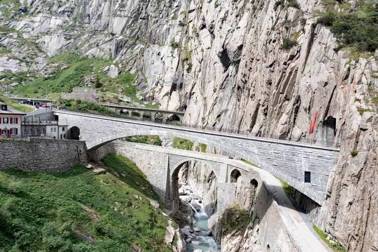
Teufelsbrucke (Devil’s Bridge)
This is an amazing feat of construction over the Schöllenen Gorge which is enclosed by scheer granite walls.
![]()
![]()
Translation of German inscription: “Around 1200 the original scorn - who knows, maybe even with the help of the devil - chuckled a masterpiece. With the construction of the Teufelsbrucke, they conquered the wild Schollen Gorge, which was previously considered impassable. This made the Gotthard route the shortest north-south connection. The villages on the route joined together to form summer cooperatives and benefited from the transport of foreign goods over the pass. In 1595 the wooden bridge were replaced by a stone building. She fell victim to a storm in 1888. In 1830 another bridge was built with the construction of the passable road, which was replaced in 1956 by today's Teufelbrucke.”
Climb summary by PJAMM Ambassador Helmuth Dekkers, Netherlands:
I started in Wassen so I could take on the Sustenpass also from the same town. From Wassen you follow the A2 towards Andermatt. Note the N2 when coming from Wassen, not so bad. After 2.3km (counted from the turnoff in Wassen to the Susten pass) you will encounter a short tunnel which is 200m long and has a shoulder on the right hand side to cycle on. A little further down the road, 4km from Wassen, you'll see a big, BIG stone with 2 flags on it on the left of you beside the road. This is the Devil's Stone (Teufelsstein) and is a large block of granite with a height of ~12 m and a mass of ~220 tons.
![]()
Photo: Wikipedia.
60m further we again face a tunnel. This one is 450m long and you can cycle on both sides on a sidewalk which is a bit higher than the road. After 5.6km you reach the 1st set of hairpin turns to the right you can see a beautiful arched stone bridge that crosses the river and in front of you the road that twists and turns while making its way upwards as it is cramped between the rock walls of the Schöllenen Gorge (German: Schöllenenschlucht). This gorge is formed by the upper Reuss river and is very narrow. The way they have built the road here is impressive and so are the sheer rock walls enclosing it. After 6km there is a gallery to protect the road against rocks falling down. It is 280m long and there is no shoulder or sidewalk here that you can use. Then a hairpin turn and again a long, 700m, rockfall gallery. You then get 4 hairpin turns tightly squeezed in the little space the gorge offers here and then again we cycle into a 350m long rockfall gallery that turns into a 50m long tunnel at the end.
At the end of the tunnel, 8.5km after we left Wassen, we reach the famous point in the Schöllenen Gorge where the so-called Devil's Bridge is located. It's a beautiful place where 2 bridges cross the Reuss river. One we use to reach the other side of the river ourselves. The other one is a bridge for pedestrians and you can see it to the right of you a little lower though. The story goes that to build the Devil's Bridge the help of the devil was called for. The Devil agreed to help but with one condition; he would have the soul of the first to cross the bridge. When the bridge was finished, the villagers chased a goat over the bridge, meaning the Devil would have its soul and not one of theirs. Angered by this trickery, the Devil seized a huge boulder to smash the newly completed bridge. Before he could do so, however, he was stopped in his tracks by a holy man with a crucifix and fled, dropping the stone. And this is the Devil's Stone we passed on our way up 🙂.
![]()
Just after you cross the bridge there is a car park to the right hand side of the road and a small restaurant on the left hand side of the road (Restaurant Teufelsbrücke). If you want to have a better view of the gorge and the 2 bridges spanning it then lock your bike here and go down to the right of the restaurant to the viewpoint. But I suggest doing that on the way back.
250m after the Devil's bridge we again face a tunnel/gallery of 400m. The amount of tunnels and rockfall galleries is of course due to the narrow gorge with steep rock walls where the road has little space and hence rockfall is a serious threat for damaging and blocking this important connection. Just after the tunnel/gallery you reach a roundabout and just follow the signs Oberalppass which is 11.5km cycling still. Just outside Andermatt the road starts to wind its way up again with some hairpin turns. 3.2km after the roundout we have a short, 150m, tunnel and the hairpins continue until the turnoff to the Nätschen ski area. You can then already see the saddle where the Oberalpsee lake is situated ahead of you. Shortly after you reached the lake there is the last rockfall gallery that is shared with the bright red trains of the Matterhorn Gotthard Bahn. This is a long one again, 750m, but fortunately flat. When you get out of it there are just 650m to the pass of which the last 250m go up.
OK, time to down so we can have a better look at the Devil's Bridge. When you reach Restaurant Teufelsbrücke then lock your bike to the guardrail and take the time for a small walk. So take along a lock and normal shoes. There is no need for real hiking shoes for the little walking you do here. Take the path left of the Teufelsbrücke Restaurant here you can walk down pass the restaurant and then you already have a nice view on the two bridges that span the gorge here. If you continue straight down then you walk to the Suworow Monument which is carved into the rocks of the Schöllenen Gorge to commemorate fallen Russian soldiers in a war with Napoleon in 1799. Or you can go beneath the road bridge and across the pedestrian bridge to the other side of the Reuss river. There you will find an entrance to a short, 90m, tunnel that brings you to a viewpoint that offers a different and better view on the 2 bridges spanning the gorge.
![]()
Thank you Helmuth Dekkers!!
Helmuth’s words of wisdom:
On this route there are many tunnels and galleries (half open tunnels where the roof protects you from falling rock but you can look outside on the valley side) one has to cycle through. When cycling via the N2 (the first 10.6 km) you will encounter numerous tunnels and galleries! I didn't feel uncomfortable cycling through these but I do recommend not to cycle that road during the weekend or holiday period as the traffic can be quite a bit more and definitely bring a tail and head light for safety. There are parts that are prohibited for cyclists but I did see many other cyclists on that road coming down or going up when I drove to my hotel. And also when I cycled it I was not the only cyclist. As long as you take precautions (lights) and avoid weekend and holiday periods you should be fine as I see it.
![]()
Tunnel locations along the route.
When the turn to the Oberalppass has been taken in Andermatt (km 10.6), the traffic reduces substantially. At the end, along the lake and near the pass there is a very long gallery. It's a bit darker than normal galleries as there is a railroad between the road and the lake going through the same gallery. But it is well lit and there is some daylight too. And due to the very low amount of traffic absolutely not a problem to cycle through with tail and headlights, of course.