

16.3
PDI
14.3 mi
DISTANCE
3,388 ft
GAINED
4.2 %
AVG. GRADE
FULL CLIMB STATS
INTRO
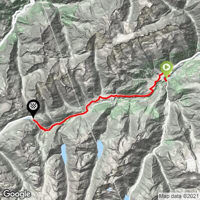
This is the Graubünden side of the Oberalp, and for its first half you're riding up the Vorderrhein - the young Rhine - through the Romansh-speaking villages of the Surselva. It starts below the big Benedictine abbey of Disentis/Mustér and doesn't feel like a mountain pass for a long time: the first 9 km to Sedrun climb gently, and the 4 km through Rueras beyond it are almost flat.
Then the valley closes in. Past Tschamut the road climbs onto open grass slopes and starts to switchback toward the pass, and the last 10 km gain about 630 m at 6.3%, with the red trains of the Matterhorn Gotthard Bahn grinding up their rack railway above you. Overall it's 23 km (14.3 mi) from 1072 m to 2040 m (3516 to 6692 ft), with 1033 m (3388 ft) of climbing at a 4.2% average.
At the top there's the Oberalpsee, the station, a restaurant and a red-and-white lighthouse that nods to the Rhine's mouth on the Dutch coast. The river's actual source, Lai da Tuma, is a short hike away on this side of the pass. Expect wind on the upper slopes - it's the thing riders mention most - and with the open valley ahead of you, it's usually in your face.
PLAN YOUR ROUTE
 We've partnered with Sherpa-Map.com to bring you the best route planning tool. With a PRO Membership you can use this climb as a reference when creating your route.
Oberalppass East climbs 1033 m (3388 ft) in 23 km (14.3 mi), from 1072 m in Disentis to 2040 m (3516 to 6692 ft) at the pass, a 4.2% average.
The climbing is lopsided. From Disentis to Sedrun, about 9 km, the road gains roughly 330 m at 3-5%, with a couple of nearly flat kilometers. From Sedrun through Rueras the next 4 km are basically level at around 1410 m.
The real climb is the last 10 km (6.2 mi): 628 m at 6.3%, never below 4%, with the steepest going on the hairpins in the final 4 km at 7-8.3%. The single hardest kilometer is 8.9% and the hardest 5 km average 7.3%, so it's steady rather than steep, but above 1700 m and often into a headwind.
Roadway: Paved throughout on Main Road 19, a well-built two-lane pass road in good condition. Through Disentis and Sedrun it's a village main street; past Tschamut it opens onto bare slopes with wide, well-engineered hairpins. The pass closes in winter. It opened on 28 April in 2023, 2 May in 2024 and 25 April in 2025, and closed on 8 November 2023, 18 November 2024, 19 November 2025 and 17 November 2026, so the season runs from about the end of April to mid-November. Check the Graubünden or Uri road status (or alpen-paesse.ch) if you're riding in spring or late autumn.
Traffic: Moderate. It's a through route between Graubünden and Uri, so expect tourist cars, campervans and plenty of motorbikes on summer weekends. Through the villages it's mostly local traffic. Weekday mornings are the quietest time to ride.
Parking: Disentis is a rail junction, which makes it easy to arrive by train and to ride one way: the Matterhorn Gotthard Bahn stops at Sedrun and at the pass, and its BikePass Gotthard covers the line between Disentis and Göschenen with self-loading bike transport. If you drive, park in Disentis and start from the village. There's also a public car park at the pass for a support car.
Gear: A compact with a 28 at the back is plenty - nothing here is steep for long. Clothing matters more than gearing: the top is above 2000 m and exposed, so carry a wind jacket and full-finger gloves for the 23 km back down, even in July.
Provisions: Disentis and Sedrun have shops, bakeries and cafes, and Sedrun, about 9 km in, is the last real village. There's a restaurant at the pass by the station and the lake.
Before heading out on any cycling adventure check out our Things to Bring on a Cycling Trip and use our interactive check list to ensure you don't forget anything.
Disentis/Mustér grew up around its Benedictine abbey, one of the oldest in Switzerland, and the baroque abbey church by Caspar Moosbrugger is open to visitors - worth a look in cleats. Disentis is also the start of the Lukmanier road south toward Ticino, so it works as a base for two passes.
Sedrun is a small ski village with a big piece of engineering history underneath it: it was one of the access points for building the 57 km Gotthard Base Tunnel, with shafts sunk about 800 m down to tunnel level.
At the pass, the trail to Lai da Tuma, the source of the Rhine, starts on the Graubünden side. Over the top, the road drops to Andermatt - our Oberalppass North page covers that side, the Schöllenen gorge and Devil's Bridge.
ROUTE MAP
MEMBER RATING
CURRENT WEATHER
PJAMM TRIPS ADVENTURE STARTER BUNDLES
Check out PJAMM Adventure's prepackaged (self-guided) cycling trips. They will help you plan, document and conquer your next adventure.
NEARBY CLIMBS (0) RADIAL PROXIMITY
FROM No Climbs Found
MEMBER REVIEWS & COMMENTS
Let us know what you thought of this climb. Signup for our FREE membership to write a review or post a comment.
Already have an account?
LOG IN HERE
