Parks Creek East Bike Climb - PJAMM Cycling

21.7
PDI
11.8 mi
DISTANCE
3,696 ft
GAINED
5.9 %
AVG. GRADE

FULL CLIMB STATS

Page Contributor(s): John Berude, Berkeley, CA, USA

INTRO

"The east side of Parks Creek is a superb mountain climb among pines in far northern California.  Somewhat shallow to start, the grade goes up and down in the early stages along with a flat section very close to climb start but soon gets more stout.  At mile 2.7 turn right to continue up the hill (head straight to a dead end and campground) into thicker woods.  It is here that the true nature of the ascent is revealed.  The road narrows to a wide single lane with a true alpine feel as it travels along the edge of the mountain with some exposure in places.  Very good views appear in spots where the trees part..." (This quote is presented with the approval of John Summerson, from his book, The Complete Guide to Climbing (by Bike) in California, pg. 62.)

PLAN YOUR ROUTE

We've partnered with Sherpa-Map.com to bring you the best route planning tool. With a PRO Membership you can use this climb as a reference when creating your route.

See more details and tools regarding this climb's grade via our interactive Profile Tool.
Information Not Available

If you have any information regarding this climb, we'd like to hear from you. Click the CONTRIBUTE button to share your thoughts with us.

Information Not Available

If you have any information regarding this climb, we'd like to hear from you. Click the CONTRIBUTE button to share your thoughts with us.

Before heading out on any cycling adventure check out our Things to Bring on a Cycling Trip and use our interactive check list to ensure you don't forget anything.
Information Not Available

If you have any information regarding this climb, we'd like to hear from you. Click the CONTRIBUTE button to share your thoughts with us.

ROUTE MAP

MEMBER RATING

Not Yet Rated
-
Road
-
Traffic
-
Scenery

CURRENT WEATHER

PJAMM TRIPS ADVENTURE STARTER BUNDLES

Check out PJAMM Adventure's prepackaged (self-guided) cycling trips. They will help you plan, document and conquer your next adventure.
ALL TRIPS
Browse all of our prepackaged trips and find your next adventure!

NEARBY CLIMBS (0) RADIAL PROXIMITY

FROM
No Climbs Found

MEMBER REVIEWS & COMMENTS

Let us know what you thought of this climb. Signup for our FREE membership to write a review or post a comment.
Already have an account?
ROUTE MAP
PROFILE TOOL
Route Data
S.G. (%)
hide
Segment Data
hide
CLIMB SUMMARY

Cycling Parks Creek Summit East - a very remote and scenic Northern California bike climb.

From the east ride 11.8 miles gaining 3,837’ to elevation 6,859’ at 5.9% average grade.

This is definitely an "out of the way" climb in a rugged area of Northern California.  These are less scenic climbs than the other Top 100’s in the area, yet they are certainly worth a go if you are in the area, have the time and have already climbed Shasta/Etna/Ashland.[1]  The climbs can be accomplished as an out-and-back from the town of Mt. Shasta (map) and done by the ambitious on the same day as Mt. Shasta, or as day 1 / day 2 climbs.  

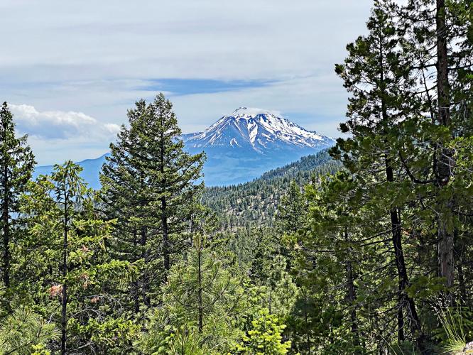
Mt. Shastina and Mt. Shasta are in sight due east at a few spots along the climb.

This is #90 on the U.S. Top 100 Climb List.  This climb is along a single lane road in an alpine setting in remote Northern California.  We ride along a ridgeline for some of the climb and have a couple nice views of Mt. Shasta to the east.  There are views of distant peaks and ridges of the Cascade Mountain Range along the way and the climb ends at the summit which  the Pacific Coast Trail crosses.  This climb is deceivingly steep over the second half (the first 5 miles are at 5.2% and the next 4 are at 7.2% before relaxing to 4.5% over the final 3 miles).  


Steepest ¼ mile begins at mile 5.2 (10.3%) and steepest mile at 5 (8.7%)

The roadway surface on this side of the summit is much better than the west side - there are a few potholes but otherwise the one lane road is in decent shape.   Traffic is very light and this is a safe climb.


[1] #59 Mt. Shasta 12 miles south,  Etna Summit  73 miles west  (via a roundabout route - not many direct routes in those parts)  and #95 Mt. Ashland 60 miles north, just across the southern Oregon border.