![]()
Cycling Oberaarsee
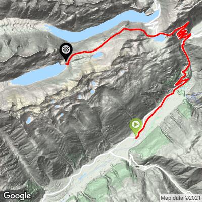
Ride 21.5 kilometers gaining 1,078 meters at 4.5% (122 meters of descent)
This is a typically scenic Swiss Alps climb to Oberaarsee, a hydroelectric dam in the bike climbing hot spot of Grimsel. There roughly 20 spectacular climbs in a 30 kilometer radius of Grimsel, including 4 Top World Bike Climbs.
Climb summary by PJAMM Ambassador Helmuth Dekkers, Netherlands.
Well, the most demanding side for the Grimselpass is the northern side from Innertkirchen. It's 32.6km of cycling to gain 1675m which results in an average of 5.1 %. But as the weather predictions were not so good I did not dare to take the risk to cycle that side as I first had to drive 42km by car via the Grimselpass to Innertkirchen. The waitress in the hotel I stayed in Obergesteln told me that I had to be careful as the low hanging clouds can make it very dangerous for cyclists at the pass as motorcyclists and car drivers don't have a good vision and she had seen plenty of accidents during the 6 years she worked for the hotel next to the pass. Second reason is that I really have grown fond of the road from Obergesteln that takes you out of the Goms valley and up to Gletsch and the road that follows 🙂.
![]()
Scenes along the climb.
Bottom center photo: Furka Steam Railway is a heritage railway operated in the area
So I started at the hotel and cycled 3km from Obergesteln to Obergoms which are fairly flat. After that the road goes up via 2 lovely hairpins (I love hairpins) and crosses the Dampfbahn Furka Bergstrecke which is a railroad track on which a steam (dampf) engine is running to take passengers from Oberwald to Realp. Shortly after you pass the Rhonequelle restaurant. And 1km further you'll pass through a very short tunnel. You can see ahead the road going up from Gletsch to the Grimselpass with numerous hairpins 🙂 But the clouds were hanging low and I did not see all the hairpins. Hmm, not sure if I would then cycle up to the pass itself.
![]()
With the warning of the waitress in the back of my mind I wore a fluorescent vest and had brought 2 tail lights and a front light too. When I turned them on I looked like a Christmas tree 🙂 But, better safe than sorry. And in the Goms valley the view was good. No need for the lights. Two hairpins take you higher up out of the valley and you can see the tunnel exit with wooden doors from the Furka Bergbahn below. The road sweeps to the right and then via another hairpin turn you reach Gletsch. When the weather permits you can see the road up to the Furkapass ahead. But to get to the Grimselpass one has to turn left to go up via a broad road with 6 hairpin turns. While making my way up I see here and there some blue sky and even the sun was peeking through the clouds. The clouds had lifted 🙂 and I could cycle with a clear view to the Grimselpass. Nice!
![]()
Next to the Grimselpass is the Totensee (Sea of the dead as soldiers were once driven into the lake to drown) . But we are not there yet. As it is possible to cycle from the Grimselpass on to the Oberaarsee. At start of the turnoff one can see the Hospice lying on its isle in the Grimselsee and the road leading down to Innertkirchen. The narrow road first goes up for 1km at 8% and then goes down again. Personally I don't like this as the height I gained is lost and for sure must be gained again. But the road is worth cycling as it runs along the Grimselsee and offers beautiful views on the lake itself, the surrounding mountains and the Unteraarglacier. The wind was chilling though. But as after the downhill it's 3.8km up again at a moderate 5% on average I got warm again.
![]()
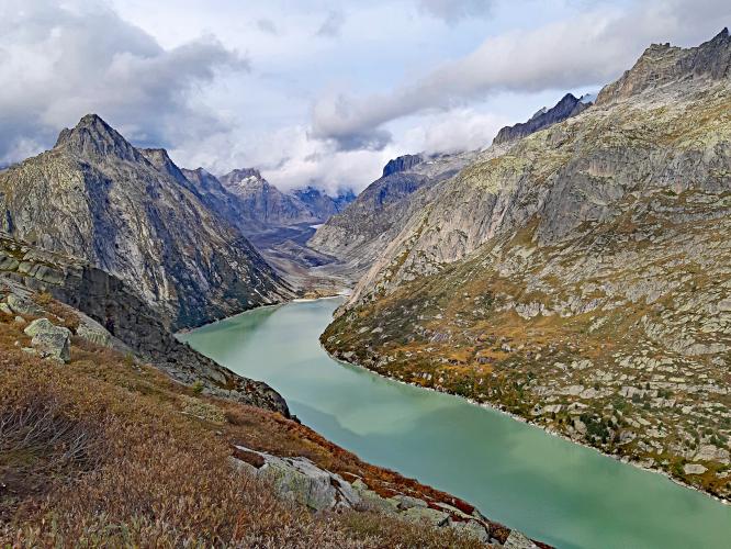
Oberaar Reservoir
At the top you can see below the dam of the Oberaar reservoir and at the far end of the reservoir you can see the Oberaar glacier. It's an impressive view! I went down the short (920m) steep (9%) road to the dam. But the view does not get better. It's just I wanted to cycle the road until the end. I felt very happy and fortunate that the weather was good enough to have cycled the beautiful road out of the Goms valley and then up via the hairpin turns to the Grimsel pass and on to the Oberaarsee.
![]()
![]()
Oberaargletscher
![]()
![]()
Helmuth at Grimsel Pass about 6 km from the finish