
20.7
PDI
5.9 mi
DISTANCE
2,759 ft
GAINED
8.9 %
AVG. GRADE
FULL CLIMB STATS
INTRO
PLAN YOUR ROUTE
 We've partnered with Sherpa-Map.com to bring you the best route planning tool. With a PRO Membership you can use this climb as a reference when creating your route.
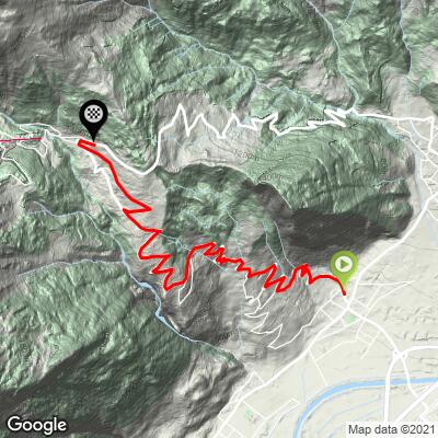
 Ovronnaz (Leytron) is 9.5 km (5.9 mi) long and gains 841 m (2,759 ft) at an 8.9% average, rising from 496 m (1,627 ft) to 1,337 m (4,386 ft).
Km 0-2: 8.3% and 8.7% - the climb has no gentle start.
Km 2-6: four kilometers between 10.2% and 10.6% - the crux, with no flat to recover on.
Km 6-9.5: 9.2%, then 6.5%, 6.9% and 6.0% toward the resort.
Steepest sections: 100 yd (91 m) at 13.6%; 0.5 km (0.3 mi) at 12.3%; 1 km (0.6 mi) at 11.2%; 1 mi (1.6 km) at 11.0%; 2 km (1.2 mi) at 11.1%; 5 km (3.1 mi) at 10.3%.
Roadway: The Route d'Ovronnaz is paved the whole way and fairly wide for a mountain road. The climb is sun-exposed with little shade on the lower slopes, so heat can be a factor in summer, and it can ice up after snowfall in winter and early spring.
Traffic: Moderate. The road serves Ovronnaz, the baths and the lifts, and is busiest on fine weekends. At harvest time in autumn, vineyard vehicles and parked trucks often take up the roadside in the lower section, so ride predictably there.
Parking: Leytron has a car park where published loop routes begin, and the climb starts a short ride away at the edge of the vineyards. Our Ovronnaz (Ardon) page covers the train-and-post-bus option from Riddes.
Gear: This is a steep climb - four straight kilometers over 10% - so a compact crank with a 34-tooth cog is the sensible choice. Bring plenty of water in summer and sun protection for the exposed lower half.
Provisions: Ovronnaz has restaurants and cafes at the top, but there is nothing on the climb, so fill bottles in Leytron.
Before heading out on any cycling adventure check out our Things to Bring on a Cycling Trip and use our interactive check list to ensure you don't forget anything.
Leytron is a wine village in the Rhone Valley, and the climb begins right at the edge of its vineyards. The Valais Tourism route from the same Route d'Ovronnaz start continues to Mayens-de-Chamoson at 1,359 m (4,459 ft), 10.8 km (6.7 mi) with 873 m (2,864 ft) of climbing - a close variant if you want to extend the effort.
Valais Tourism suggests a soak in the thermal baths of Ovronnaz or nearby Saillon, and a detour through the wine village of Chamoson on the descent. Our Ovronnaz (Ardon) page covers the other approach and what to do at the resort.
Check current conditions before you go with our Weather tool, especially for heat on the lower slopes.
ROUTE MAP
MEMBER RATING
CURRENT WEATHER
PJAMM TRIPS ADVENTURE STARTER BUNDLES
Check out PJAMM Adventure's prepackaged (self-guided) cycling trips. They will help you plan, document and conquer your next adventure.
NEARBY CLIMBS (0) RADIAL PROXIMITY
FROM No Climbs Found
MEMBER REVIEWS & COMMENTS
Let us know what you thought of this climb. Signup for our FREE membership to write a review or post a comment.
Already have an account?
LOG IN HERE
