
24
PDI
12 mi
DISTANCE
4,038 ft
GAINED
6.3 %
AVG. GRADE
FULL CLIMB STATS
INTRO
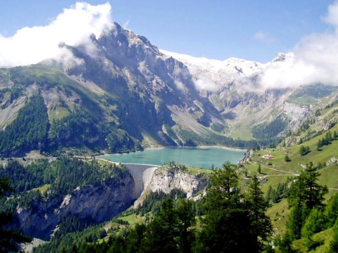
The Lac de Tseuzier - also known as the Lac du Rawil or Zeuzier - is a turquoise reservoir tucked into the head of the Liène valley above Sion, held back by a 156 m (512 ft) arch dam. The climb from Sion runs 19.3 km (12.0 mi) and gains 1231 m (4,038 ft) at a 6.3% average, rising from the Rhône valley floor through vineyards, the villages of Ayent and larch forest, and finally through a string of tunnels to the dam.
It's a varied, three-part climb: a steady 6.8% out of Sion through the vines to Botyre, an easier middle section through the upper villages of Ayent, then 6.8 km (4.2 mi) at 8.2% up the forested Liène valley. The last 1.2 km (0.8 mi) is nearly flat and runs mostly through lit tunnels before you emerge beside the lake, with the limestone peaks of the Wildhorn massif rising beyond. Above Ayent the road is a dead end, so the upper half feels remarkably remote for a climb that starts in a regional capital.
The dam has an unusual backstory. Built between 1953 and 1957, it was damaged in 1978-79 when an exploratory gallery for the planned Rawil motorway tunnel, driven some 400 m beneath the reservoir, struck heavy groundwater inflows and the ground under the dam settled by up to 13 cm. The lake was drained, the tunnel work was halted, and the repaired dam returned to normal operation in 1989. The upper road is closed by snow in winter, typically from November.
PLAN YOUR ROUTE
 We've partnered with Sherpa-Map.com to bring you the best route planning tool. With a PRO Membership you can use this climb as a reference when creating your route.
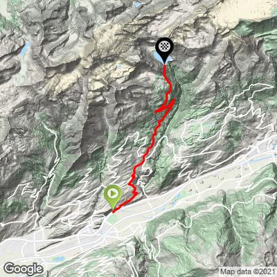
 Lac de Tseuzier from Sion covers 19.3 km (12.0 mi) and gains 1231 m (4,038 ft) at an average of 6.3%, starting at 507 m (1,665 ft) on the edge of Sion.
Km 0-6.5: 6.5 km (4.0 mi) at 6.8% through the vineyards to Botyre - the opening kilometer is one of the steepest of the whole climb at about 9.6%.
Km 6.5-11.2: 4.7 km (2.9 mi) at a gentler 4.2% through the upper villages of Ayent, including a near-flat kilometer.
Km 11.2-18: the crux, 6.8 km (4.2 mi) at 8.2% - a long, consistent grind at 8-9% up the Liène valley.
Km 18-19.3: 1.2 km (0.8 mi) of near-flat road, mostly in tunnels, to the dam.
Km 6.5-11.2: 4.7 km (2.9 mi) at a gentler 4.2% through the upper villages of Ayent, including a near-flat kilometer.
Km 11.2-18: the crux, 6.8 km (4.2 mi) at 8.2% - a long, consistent grind at 8-9% up the Liène valley.
Km 18-19.3: 1.2 km (0.8 mi) of near-flat road, mostly in tunnels, to the dam.
The steepest kilometer averages 9.6% and the steepest 2 km average 8.9%.
Roadway: Paved all the way to the dam. The final stretch runs through several tunnels, a couple of them long - they are lit, but a rear light is still a good idea. The upper road (Route du Rawil) is closed by snow in winter, typically from November until late spring; the 2026 summer shuttle from Anzère serves the dam through 1 November, a useful guide to the open season.
Traffic: Moderate on the lower roads through the Sion vineyards and Ayent's villages, which carry local traffic. Above Ayent the dam road is a dead end and traffic is light - mostly hikers' cars, the PostBus and the Anzère shuttle. For the Ride the Alps event on 28 June 2026, the road from the Combe de Voos to the dam was reserved for cyclists from 9 am to 3 pm, and events like it recur.
Parking: Start from Sion, where the train station and the public car parks around the town center - including the Scex, Roches-Brunes and Planta lots - are a short ride from the base of the climb.
Gear: A compact crankset with a 32- or 34-tooth cog helps on the sustained 8-9% of the Liène valley section. Bring a rear light, ideally a front one too, for the tunnels near the top, and a layer for the descent - the dam sits some 1200 m above Sion, and the valley-floor heat doesn't follow you up.
Provisions: Sion and the villages of Ayent have shops and cafes for the first half of the climb, but there is nothing once you leave Ayent's upper villages, so fill bottles before the forest section. At the top, the restaurant at the dam serves meals in season, including raclette.
Before heading out on any cycling adventure check out our Things to Bring on a Cycling Trip and use our interactive check list to ensure you don't forget anything.
This is one of the easiest big Valais climbs to ride one way: PostBus line 352 runs from Sion to the Lac de Tseuzier, and the Anzère summer shuttle to the dam carries bikes free of charge (in 2026 it runs Wednesday to Sunday from 20 June to 23 August, then Wednesdays and weekends until 1 November).
On the way up you pass through Botyre, home of the Musée valaisan des Bisses in a 17th-century painted house, which tells the story of the Valais's centuries-old irrigation channels (open mid-April to mid-November). At the top, the Grand Bisse d'Ayent footpath leads down from the lake alongside one of those channels, and an easy loop of the reservoir takes about an hour and a half on foot.
Tseuzier sits in one of the densest clusters of big climbs in the Alps - see other climbs nearby, or build a custom route from here, with our Routes in the Area tool.
ROUTE MAP
MEMBER RATING
CURRENT WEATHER
PJAMM TRIPS ADVENTURE STARTER BUNDLES
Check out PJAMM Adventure's prepackaged (self-guided) cycling trips. They will help you plan, document and conquer your next adventure.
NEARBY CLIMBS (0) RADIAL PROXIMITY
FROM No Climbs Found
MEMBER REVIEWS & COMMENTS
Let us know what you thought of this climb. Signup for our FREE membership to write a review or post a comment.
Already have an account?
LOG IN HERE
