
19.7
PDI
8.6 mi
DISTANCE
3,129 ft
GAINED
6.9 %
AVG. GRADE
FULL CLIMB STATS
INTRO
PLAN YOUR ROUTE
 We've partnered with Sherpa-Map.com to bring you the best route planning tool. With a PRO Membership you can use this climb as a reference when creating your route.
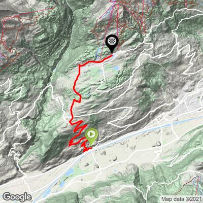
Crans Montana (Lens) averages 6.9% over 13.8 km (8.6 mi), gaining 954 m (3,129 ft), and it is remarkably even.
Km 0-5 (0-3.1 mi): 7.5% - out of Granges with an 8.4% first kilometer, then up to Flanthey.
Km 5-12 (3.1-7.5 mi): 7.3% - the long, steady middle on the Route Lens-Crans, with the odd kilometer touching 8%.
Km 12-13.8 (7.5-8.6 mi): 3.6% as the road eases onto the resort plateau.
Km 5-12 (3.1-7.5 mi): 7.3% - the long, steady middle on the Route Lens-Crans, with the odd kilometer touching 8%.
Km 12-13.8 (7.5-8.6 mi): 3.6% as the road eases onto the resort plateau.
The steepest 500 m averages 10.1%, the steepest kilometer (0.6 mi) 8.7%, the steepest 2 km (1.2 mi) 8.1%, the steepest 5 km (3.1 mi) 7.7% and the steepest 10 km (6.2 mi) 7.5%. The challenge is length at a consistent effort rather than any single ramp.
Roadway: The road is paved the entire way, from the Route de Granges through Flanthey and the Route Lens-Crans to the Route du Rawyl in Montana. It serves a year-round resort and ski area, so it is maintained through the winter, though ice and snow are possible near the top from late autumn into spring. The slope faces the sun, so July and August afternoons can be hot.
Traffic: Light to moderate on the village roads below Lens and heavier near the resort, especially on summer weekends and during the ski season. Early morning is both quietest and coolest.
Parking: Granges is a village on the valley floor in the Sierre area, so street parking there puts you on the Route de Granges. For a larger option, the Park+Ride at Sierre's railway station is a short ride from the start - see our Crans Montana (Sierre) page for details on Sierre and the funicular.
Gear: A compact crankset with a 30-34 tooth rear cog keeps the steady 7-8% comfortable. Bring sun protection and a light layer for the descent - the resort sits roughly 950 m above the start.
Provisions: Stock up before the start and fill your bottles in Flanthey or Lens; the climb is sun-exposed and takes most riders well over an hour. Crans-Montana has plenty of cafes and restaurants at the top.
Before heading out on any cycling adventure check out our Things to Bring on a Cycling Trip and use our interactive check list to ensure you don't forget anything.
The Lens approach is a village climb, and the villages are worth a look. Lens and Flanthey sit in a belt of vineyards and farmland on the right bank of the Rhône, and the church of Saint Peter in Lens has been enlarged several times since the Middle Ages. Hikers can follow the Grand Bisse de Lens, a 14 km (8.7 mi) irrigation channel path of about four hours that runs from the Lienne through Icogne, Lens and Chermignon to Montana, with exceptional views over the Rhône valley (the path runs along rock faces in places, so take care).
Resort town logistics - the Sierre funicular, the Stephani car park, the Omega European Masters and the Col de Crans-Montana - are covered on our Crans Montana (Sierre) page, and the Sion approach has its own Crans Montana (Sion) page. For a quieter alternative, Chandolin starts nearby in Chippis. At roughly 1,500 m (4,921 ft) the resort can be several degrees cooler than the valley, so check our Weather tool for conditions at the top before you set out.
ROUTE MAP
MEMBER RATING
CURRENT WEATHER
PJAMM TRIPS ADVENTURE STARTER BUNDLES
Check out PJAMM Adventure's prepackaged (self-guided) cycling trips. They will help you plan, document and conquer your next adventure.
NEARBY CLIMBS (0) RADIAL PROXIMITY
FROM No Climbs Found
MEMBER REVIEWS & COMMENTS
Let us know what you thought of this climb. Signup for our FREE membership to write a review or post a comment.
Already have an account?
LOG IN HERE
