
19.7
PDI
8.6 mi
DISTANCE
3,143 ft
GAINED
6.9 %
AVG. GRADE
FULL CLIMB STATS
INTRO
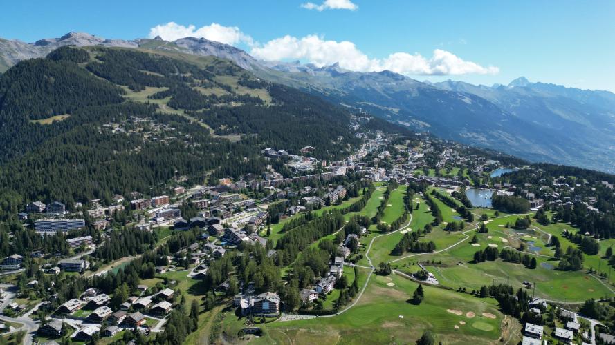
Crans Montana (Sierre) climbs 13.9 km (8.6 mi) from Sierre, on the floor of the Rhône valley, to the resort of Crans-Montana, gaining 958 m (3,143 ft) at a 6.9% average. It starts at 548 m (1,799 ft) and finishes at 1,506 m (4,942 ft) on the sunny plateau that Montana and Crans share above the valley.
This is a steady, no-surprises climb rather than a wall. Most kilometers sit between 7% and 8%, the steepest 500 m average 8.9%, and the only real relief comes in the last two kilometers as the road flattens onto the plateau. The slope faces the sun, so summer afternoons can be hot and an early start pays off.
Crans-Montana is a genuine cycling name. Stage 20 of the 1984 Tour de France, 141 km from Morzine, finished here and was won by Laurent Fignon, and the Tour de Suisse has ended stages in the resort seven times.
PLAN YOUR ROUTE
 We've partnered with Sherpa-Map.com to bring you the best route planning tool. With a PRO Membership you can use this climb as a reference when creating your route.
Crans Montana (Sierre) is 13.9 km (8.6 mi) long and gains 958 m (3,143 ft) at a 6.9% average, from 548 m (1,799 ft) in Sierre to 1,506 m (4,942 ft) in the resort.
Km 0-2 (0-1.2 mi): 6.5% as the road leaves Sierre, with the second kilometer the easiest of the climb at 5.7%.
Km 2-8 (1.2-5.0 mi): 7.6%, with the kilometers around the 3 km and 7 km marks closest to 8%.
Km 8-12 (5.0-7.5 mi): 7.5% - the last sustained effort.
Km 12-13.9 (7.5-8.6 mi): 4.0% as the road eases onto the plateau.
Km 2-8 (1.2-5.0 mi): 7.6%, with the kilometers around the 3 km and 7 km marks closest to 8%.
Km 8-12 (5.0-7.5 mi): 7.5% - the last sustained effort.
Km 12-13.9 (7.5-8.6 mi): 4.0% as the road eases onto the plateau.
There are no extreme pitches. The steepest 500 m average 8.9%, the steepest 1 km 8.5%, the steepest 2 km 8.2% and the steepest 5 km 7.7%, so the challenge is the length of the sustained 7-8% rather than any single ramp.
Roadway: The road is paved from Sierre all the way to Crans-Montana. It is a public road serving a year-round resort and ski area, so it is maintained through the winter, though ice and snow are possible at the top from late autumn into spring. The slope is exposed to the sun, so both the air and the asphalt can be hot in July and August.
Traffic: Traffic is steady on the main resort road, and one rider described cars the whole way up. It builds on summer weekends and during the ski season and is lightest early in the morning, which is also the cooler time to climb.
Parking: Sierre (Siders) has a Park+Ride at the railway station, a short ride from the start, and the station is also the lower end of the Sierre-Montana-Crans funicular. At the finish, the Stephani car park in Montana, signed to Ycoor, is a paid lot with about 140 spaces.
Gear: A compact crankset with a 30-34 tooth rear cog keeps the sustained 7-8% comfortable for most riders. Bring sun protection, and a light layer for the descent - the resort sits nearly 1,000 m above Sierre.
Provisions: Stock up in Sierre, where shops and cafes are easy to find, and carry enough water for a climb that takes most riders well over an hour on a sun-exposed slope. Crans-Montana has plenty of cafes and restaurants at the top.
Before heading out on any cycling adventure check out our Things to Bring on a Cycling Trip and use our interactive check list to ensure you don't forget anything.
Sierre makes an easy base: it sits on the main Rhône valley rail line, bills itself as one of Switzerland's sunniest towns, and its station is the lower terminus of the Sierre-Montana-Crans funicular. Opened in 1911 and rebuilt in 2022, the funicular covers roughly 4.3 km in about 14 minutes - a handy way up to the resort without driving. Check with the operator about bikes before planning to ride up and take it down.
Crans-Montana is as much a golf and ski resort as a cycling one: the Omega European Masters is played at Crans-sur-Sierre every September, so rooms tighten then, and the Plaine Morte glacier tops a ski area reaching 2,927 m. For more climbing after the finish, the Col de Crans-Montana (1,804 m) sits above the resort - a 5.6 km road from the Violettes gondola base station in Montana - and from Aminona the view takes in the Weisshorn, Zinalrothorn, Obergabelhorn, Matterhorn and Dent Blanche.
Our Crans Montana (Sion) and Crans Montana (Lens) climbs reach the same resort from the other two sides, and Chandolin starts nearby in Chippis. To link several Valais climbs into one trip, our Routes in the Area tool lists what is close by.
ROUTE MAP

MEMBER RATING
CURRENT WEATHER
PJAMM TRIPS ADVENTURE STARTER BUNDLES
Check out PJAMM Adventure's prepackaged (self-guided) cycling trips. They will help you plan, document and conquer your next adventure.
NEARBY CLIMBS (0) RADIAL PROXIMITY
FROM No Climbs Found
MEMBER REVIEWS & COMMENTS
Let us know what you thought of this climb. Signup for our FREE membership to write a review or post a comment.
Already have an account?
LOG IN HERE
