
22.4
PDI
8 mi
DISTANCE
3,273 ft
GAINED
7.8 %
AVG. GRADE
FULL CLIMB STATS
INTRO
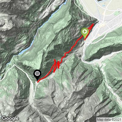
Col de la Forclaz climbs 12.9 km (8.0 mi) out of Martigny, in Switzerland's Valais canton, gaining 998 m (3,273 ft) at a 7.8% average grade to a 1,527 m (5,010 ft) pass on the historic route between the Rhône valley and Chamonix, France.
The road began as a mule-and-smuggler track zig-zagging up the mountainside; a carriage road replaced it starting in 1827, and the last French administrator of the old Simplon department is said to have fled over this pass in the winter of 1813 as Napoleon's rule collapsed. Cars weren't allowed to cross until 1912, and the road in its current form dates only to 1957. A restaurant and shop still operate at the summit, much as inns have here since the pass first saw regular travelers.
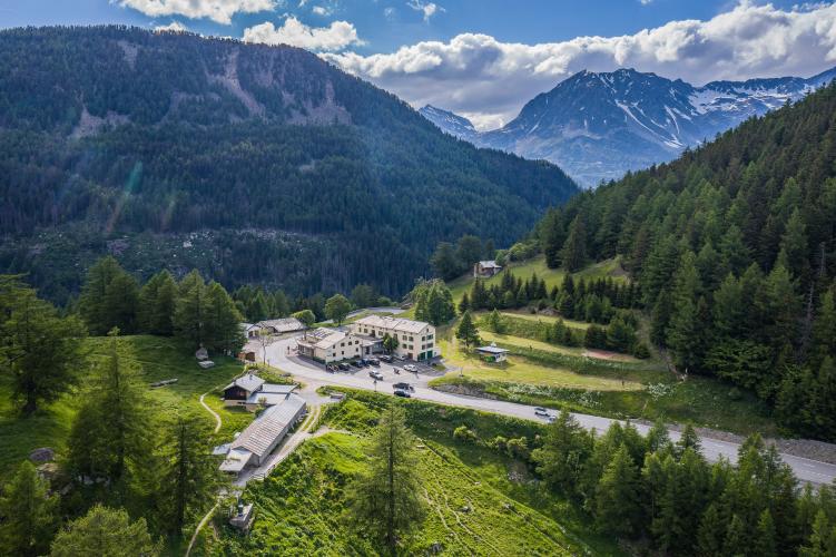
This is also, unusually for a quiet Alpine pass, a real strategic route: hidden Swiss WWII bunkers disguised as hay barns and chalets still ring the col as part of the country's wartime "National Redoubt" defenses, with an exhibition on the fortifications open at the summit. From the top, the Trient valley and the glaciers above Chamonix open up to the south, with Martigny and the Rhône valley below to the north.
PLAN YOUR ROUTE
 We've partnered with Sherpa-Map.com to bring you the best route planning tool. With a PRO Membership you can use this climb as a reference when creating your route.
 Col de la Forclaz averages 7.8% over 12.9 km (8.0 mi), and unlike many Alpine climbs it holds that grade with very little variation - there's no long flat stretch or descent to recover on anywhere along the route.
The first 3 km out of Martigny climb through vineyards and are the most exposed to sun; the road then shifts into forest and meadow for a shadier, steadier middle section before easing slightly into the final kilometer at the summit.
Roadway: Fully paved and in excellent condition - this is a year-round link between Martigny and the Trient valley (weather permitting), not a dead-end tourist road, so it's well maintained. Snow can close the pass or require chains in winter, but paving quality itself isn't an issue in the riding season.
Traffic: This is one of the busier climbs in the region - it's a genuine through-route toward Chamonix and France, not just a local access road, so expect real car and truck traffic rather than the light traffic typical of a dead-end Alpine pass. Early morning is meaningfully quieter.
Parking: Follow Martigny's parking guidance signage near the train station at the base. Martigny itself has ample public parking, plus bike shops and full services for anyone combining this with other Valais climbs.
A standard road bike is fine - the surface is excellent throughout. Given the sustained 7.8% grade with no real recovery section, gearing that lets you sit and spin rather than grind is worth having, especially through the exposed vineyard kilometers out of Martigny in summer heat.
The restaurant at the summit covers food and water at the top; Martigny has full bike shop and grocery services at the base, so there's no need to carry more than you'd want for the climb itself.
Before heading out on any cycling adventure check out our Things to Bring on a Cycling Trip and use our interactive check list to ensure you don't forget anything.
Martigny anchors this whole corner of the Valais - see our other climbs nearby for the full list - so we'll keep this to what's specific to the Forclaz itself rather than repeating the town's hotel and rail options.
The pass is a waypoint on the Tour du Mont Blanc's Bovine variant, so it's common to see through-hikers as well as cyclists at the summit in season. A short walk from the col leads to a viewpoint over the Trient Glacier, and the col also marks the eastern end of Switzerland's WWII "National Redoubt" defenses in this sector - a small exhibition on the hidden bunkers and fortifications, several disguised as hay barns, is open at the summit for anyone curious about the pass's wartime history.
The Forclaz also featured on the road to the Emosson dam finish of Stage 17 of the 2016 Tour de France - see our Lac du Vieux-Emosson climb page for more on that stage and the dam itself.
ROUTE MAP
MEMBER RATING
CURRENT WEATHER
PJAMM TRIPS ADVENTURE STARTER BUNDLES
Check out PJAMM Adventure's prepackaged (self-guided) cycling trips. They will help you plan, document and conquer your next adventure.
NEARBY CLIMBS (0) RADIAL PROXIMITY
FROM No Climbs Found
MEMBER REVIEWS & COMMENTS
Let us know what you thought of this climb. Signup for our FREE membership to write a review or post a comment.
Already have an account?
LOG IN HERE
