
17.2
PDI
5 mi
DISTANCE
2,311 ft
GAINED
8.6 %
AVG. GRADE
FULL CLIMB STATS
INTRO
PLAN YOUR ROUTE
 We've partnered with Sherpa-Map.com to bring you the best route planning tool. With a PRO Membership you can use this climb as a reference when creating your route.
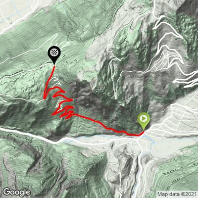
Our route runs 7.9 km (5.0 mi) from 731 m (2397 ft) to 1411 m (4629 ft), gaining 704 m (2311 ft) at 8.6% on average. The first kilometer is the gentlest at about 6%, with a sharp ramp as the road swings up above Sembrancher. From there to Vens it holds 8-9% with a few steeper pitches in the forest hairpins, eases to around 3% near the hamlet at 4 km (2.5 mi), and then stays at 8-11% for most of the last 3.5 km (2.2 mi).
The steepest kilometer averages 12.4%, the hardest 2 km (1.2 mi) 11.4% and the hardest 5 km (3.1 mi) 9.3%. Short ramps in the low teens turn up in the upper hairpins, and the 6-8 km stretch is where most riders feel it.
Roadway: Tarmac from bottom to top - the Route de Vens to the hamlet, then the Route du Col des Planches to the top. It's a narrow mountain road, in good shape for most of the climb according to riders, with rougher patches in the upper section just below the pass. Beyond the col the track toward the Col du Lein is unpaved. At 1411 m the top section can hold snow well into spring, so this is a late-spring-to-autumn ride.
Traffic: The only stressful part is the approach: the main road from Martigny up to Sembrancher and on to Verbier is busy and fast, so take care getting to the start. Once you turn onto the Route de Vens traffic is light, and above Vens you may not see a car.
Parking: Sembrancher has a station on the St-Bernard Express line from Martigny, so you can come by train and roll a few hundred meters to the start. Drivers can park in the village and ride out to the junction where the Route de Vens leaves the Verbier road (Street View).
Gear: Save your lowest gears for the last 3 km rather than the first - that's where the grade sits at 10-11% for long stretches. If you plan to come down the Martigny side, check your brakes and pack a layer: it's steep, narrow and fast.
Provisions: Fill bottles in Sembrancher - there's nothing on the way up apart from the houses of Vens. The Buvette d'Alpage du Col des Planches, on the left just before the pass, sells its own cheese, serac and tommes in season (in 2026 it opened daily 9:00-19:00 from June 6 to September 13, weather permitting; cash and Twint only).
Before heading out on any cycling adventure check out our Things to Bring on a Cycling Trip and use our interactive check list to ensure you don't forget anything.
Sembrancher is a small village where the Val de Bagnes and the Val d'Entremont meet, and the St-Bernard Express trains split here for Le Châble and Orsières - handy if you'd rather leave the car behind. For more choice of hotels, restaurants and bike shops, base yourself in Martigny down the valley or in Verbier up the road.
From the pass you can turn around, drop down the steep Martigny side (our Col des Planches (Martigny) page covers it as a climb) and loop back up the valley road, or carry on along the gravel toward the Col du Lein if your bike can handle it. Valais's Ride the Alps series has used this road and the Col du Lein for a car-free day out of Vollèges, with raclette at each summit - worth checking the calendar if you're planning a trip.
Sembrancher sits within easy reach of the Grand St. Bernard, Champex, Mauvoisin and the climbs above Verbier, and opening Routes in the Area from this page shows how they link up from here.
ROUTE MAP
MEMBER RATING
CURRENT WEATHER
PJAMM TRIPS ADVENTURE STARTER BUNDLES
Check out PJAMM Adventure's prepackaged (self-guided) cycling trips. They will help you plan, document and conquer your next adventure.
NEARBY CLIMBS (0) RADIAL PROXIMITY
FROM No Climbs Found
MEMBER REVIEWS & COMMENTS
Let us know what you thought of this climb. Signup for our FREE membership to write a review or post a comment.
Already have an account?
LOG IN HERE
