
20.5
PDI
20.7 mi
DISTANCE
4,519 ft
GAINED
4 %
AVG. GRADE
FULL CLIMB STATS
INTRO
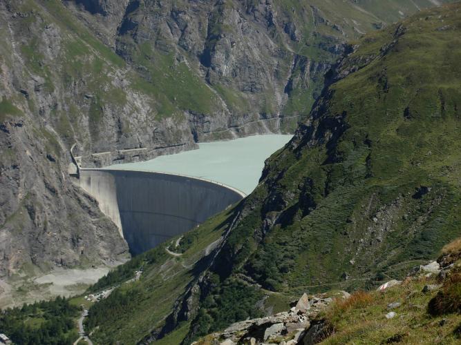
The Barrage de Mauvoisin climb runs 33.2 km (20.7 mi) from Martigny, in Switzerland's Valais, up the Val de Bagnes to the foot of the Mauvoisin dam. It gains 1,377 m (4,519 ft) at a 4.0% average grade, from about 515 m (1,688 ft) in the Rhône valley to 1,838 m (6,031 ft). That average hides the shape of the ride: the lower valley is gentle, and the real climbing waits in the upper valley, where the steepest 10 km (6.2 mi) averages 6.6% and the steepest kilometer reaches 9.5%.
The road follows the Dranse past Sembrancher and Le Châble, then through the villages of Versegères, Champsec, Lourtier, Fionnay and Bonatchiesse. The valley narrows and gets wilder as you climb, with short galleries and wooden bridges over side torrents, and the Grand Combin (4,314 m / 14,121 ft) showing along the way. The road is a dead end, so there is no through traffic, and it finishes below a wall that is 250 m (820 ft) high. The dam was built between 1951 and 1957, raised in 1991, and holds back a reservoir of 211.5 million cubic meters.
One current condition is worth knowing about. Debris flows from the Fregnoley torrent, between Champsec and Lourtier, cut the valley road in 2025. A protective gallery there is due to enter service in late November 2026, and until then traffic is routed onto a communal road on the left bank of the Dranse. Check the Val de Bagnes commune's road information before you ride.
PLAN YOUR ROUTE
 We've partnered with Sherpa-Map.com to bring you the best route planning tool. With a PRO Membership you can use this climb as a reference when creating your route.
The climb covers 33.2 km (20.7 mi) and gains 1,377 m (4,519 ft) at a 4.0% average, from about 515 m (1,688 ft) to 1,838 m (6,031 ft). Because so much of the lower valley is nearly flat, the average understates the effort in the upper valley.
The steepest 10 km (6.2 mi) averages 6.6%, the steepest 5 km (3.1 mi) averages 8.0%, the steepest 2 km (1.2 mi) averages 8.8%, and the steepest single kilometer averages 9.5%. The steepest half kilometer (0.3 mi) runs at 10.6%.
Valais Tourism notes that there are no major climbs until the Fregnoley torrent above Champsec. After that the road alternates between climbing and flatter, or even slightly descending, stretches, so you get short chances to recover. Ride the lower valley as a warm-up and save your legs for the second half.
Roadway: The road is paved all the way up the valley, with a handful of short galleries (tunnels) and wooden bridges in the upper valley. If you want to avoid tunnels, a narrow summer road on the right bank of the Dranse leaves Lourtier and bypasses two of them, including a very long one. The valley road is normally ridden from June to October, and snow can close the road and its galleries outside the summer season. Between Champsec and Lourtier, traffic is currently diverted onto a communal road on the left bank around the Fregnoley torrent while a protective gallery is finished (due late November 2026) - check the Val de Bagnes commune's road information before you go.
Traffic: Light. This is a dead-end valley road, so it carries mostly local traffic and service vehicles, and there is no through traffic. The road narrows again above Fionnay on the way to the dam.
Parking: Our route starts near Martigny, where our Col de la Forclaz page covers station-side parking. To skip the flat lower valley, park at Le Châble train station, which is the start of Valais Tourism's 18.3 km (11.4 mi) route to the dam with 1,020 m (3,346 ft) of climbing. At the top there is parking near the dam, and the Hôtel de Mauvoisin has its own.
A standard road setup is fine. The steepest kilometer is 9.5%, so ordinary road gearing is enough, but the day is long, so bring food for the 33.2 km (20.7 mi). A front and rear light are worth carrying for the galleries in the upper valley.
Switzerland uses francs, so carry a little cash for the cafes in Le Châble and the restaurant at the dam. The Hôtel de Mauvoisin restaurant is seasonal (open daily from 29 June to 15 October in 2026). A free charging station for e-bike batteries is available at Mauvoisin. At 1,838 m (6,031 ft) it is noticeably cooler and windier than the Rhône valley, so pack a jacket for the descent.
Before heading out on any cycling adventure check out our Things to Bring on a Cycling Trip and use our interactive check list to ensure you don't forget anything.
Martigny is the valley's rail and services hub and is covered on our Col de la Forclaz and Col des Planches pages, so this section sticks to the Val de Bagnes. From Martigny you can take the St-Bernard Express train to Le Châble, and in season a TMR bus (line 12.253) runs from Le Châble station up to Mauvoisin, though runs are few, so check tmrsa.ch for the timetable.
At the dam, the Sentier du barrage is free. A 392 m (1,286 ft) gallery cut into the rock leads to the crest at about 1,975 m (6,480 ft), with photos and panels on how the dam was built. Allow about 30 minutes on foot from the parking or bus stop, and note that the ground is awkward in cleated shoes. The dam also helps protect the Bagnes and Rhône valleys from glacier-lake floods like those of 1595 and 1818.
The Hôtel de Mauvoisin sits at about 1,948 m (6,391 ft) at the foot of the dam. It has a restaurant with seasonal regional cooking, a terrace, five double rooms and a 20-bed dormitory, and is open daily from late June to mid-October in 2026. Conditions at the dam can differ sharply from Martigny, so check them before you go with our Weather tool.
ROUTE MAP

MEMBER RATING
CURRENT WEATHER
PJAMM TRIPS ADVENTURE STARTER BUNDLES
Check out PJAMM Adventure's prepackaged (self-guided) cycling trips. They will help you plan, document and conquer your next adventure.
NEARBY CLIMBS (0) RADIAL PROXIMITY
FROM No Climbs Found
MEMBER REVIEWS & COMMENTS
Let us know what you thought of this climb. Signup for our FREE membership to write a review or post a comment.
Already have an account?
LOG IN HERE
