![IMG_6979.JPG]()
Cycling Hwy 18 North - this US 100 bike ride is on a fairly busy highway.
Ride 10.8 miles gaining 3,580’ to elevation 6,833’ at 6.2%
![IMG_6979.JPG]()
Ride through a tight canyon the first one-half of the climb.
This route takes us up towards the town of Big Bear City (pop. 12,304 in 2010) and Big Bear Lake from the east side of the San Bernardino National Forest. The top 100 climbs of Hwy 330 and Hwy 38 access Big Bear from the opposite (southwestern) side of the San Bernardino Mountains. However, we must regretfully recommend against this climb due to the high and fast moving traffic on it. If not for the traffic, this would be an excellent overall ride and climb. We begin at the sign for the Lazy Lizard Ranch and its very cool sign.
![IMG_6979.JPG]()
Climb begins on Hwy 18 just south of its intersection with Hwy 247
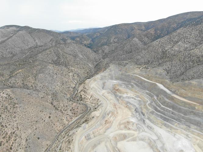
Unfortunately, there is a quarry and cement processing plant along the first 5 miles of our route which puts an uncomfortable amount of big rig traffic on the road with and close to us.
![IMG_6994.JPG]()
![IMG_6994.JPG]()
![IMG_7014.JPG]()
![]()
Enter San Bernardino National Forest at mile 4.3
Established 1907 by Teddy Roosevelt; 823,816 acres.
There are several segments where we have great views of distant planes to the east and northeast as we gain altitude, a smattering of Joshua Trees and some nice rock formations over the final 5 miles that make for pleasant views and a scenic ride. There are also some stretches of low double digit climbing, primarily over the lasts few miles of the climb.
![IMG_6994.JPG]()
And some blind corners that are a bit dicey.
![IMG_6994.JPG]()
Top of the climb - awesome descent!
![]()
Steepest ¼ mile begins at mile 5.8 (11.3) and steepest mile at 5.1 (10.1%)
The roadway is in good condition and there is a 2’ or greater designated shoulder for much of the climb. However, as noted, there is moderate traffic on this highway, including a good number of big rigs, that travel by at quite high speed, particularly for the first-half of the ride. There is also a stretch of switchbacks between mile 6-7 and the last 1.5 miles where there is no shoulder and a brief period where the cyclist is in the downhill driver's blind spot that is disconcerting.

 We've partnered with Sherpa-Map.com to bring you the best route planning tool. With a PRO Membership you can use this climb as a reference when creating your route.

