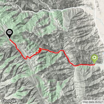
Gates Canyon Bike Climb - PJAMM Cycling

6.2
FIETS
4.9 mi
DISTANCE
2,298 ft
GAINED
8.9 %
AVG. GRADE

FULL CLIMB STATS

INTRO

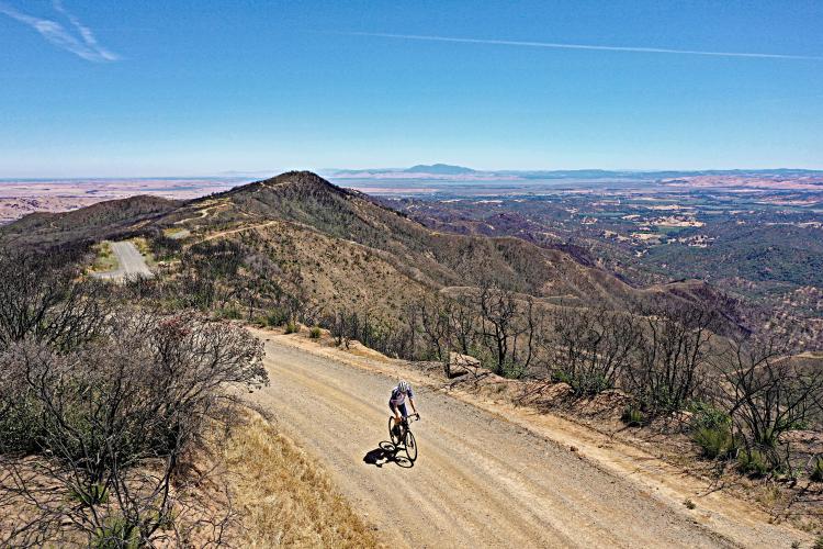
This is a hidden gem in the English Hills north of Vacaville that can be done as a loop, or separate climb in conjunction with, the extremely popular Mix Canyon Road climb.  Much of the climb is gravel but is manageable on a road bike with wider tires - see Full Summary for more information. 

See more details and tools regarding this climb's grade via our interactive Profile Tool.
Information Not Available

If you have any information regarding this climb, we'd like to hear from you. Click the CONTRIBUTE button to share your thoughts with us.

Information Not Available

If you have any information regarding this climb, we'd like to hear from you. Click the CONTRIBUTE button to share your thoughts with us.

Before heading out on any cycling adventure check out our Things to Bring on a Cycling Trip and use our interactive check list to ensure you don't forget anything.
Information Not Available

If you have any information regarding this climb, we'd like to hear from you. Click the CONTRIBUTE button to share your thoughts with us.

ROUTE MAP

MEMBER RATING

Difficulty: Challenging
3
Road
5
Traffic
3
Scenery

CURRENT WEATHER

PJAMM TRIPS ADVENTURE STARTER BUNDLES

Check out PJAMM Adventure's prepackaged (self-guided) cycling trips. They will help you plan, document and conquer your next adventure.
ALL TRIPS
Browse all of our prepackaged trips and find your next adventure!
San Francisco Bay Area
United States (CA)
25 ROUTES
30 POIs
ROUTE STATS (TOTAL)
487.9
mi
DISTANCE
65,482
ft
ELEV. GAIN
Sonoma County
United States (CA)
19 ROUTES
39 POIs
ROUTE STATS (TOTAL)
269.3
mi
DISTANCE
41,801
ft
ELEV. GAIN

NEARBY CLIMBS (0) RADIAL PROXIMITY

FROM
No Climbs Found

MEMBER REVIEWS & COMMENTS

Let us know what you thought of this climb. Signup for our FREE membership to write a review or post a comment.
Already have an account?

Feb 21, 2024
difficulty: Challenging
scenery: 3
traffic: 5
road: 3
Feb 21, 2024
scenery: 3
traffic: 5
road: 3
I’d call this climb strenuous instead of challenging based on the grade, but because it doesn’t last more than about an hour it doesn’t kill you provided you’ve got the gearing for it. Cars are at risk of coming up or down at any time, so you do need to watch out for them at any time because it’s basically just a 1 lane road up there, but I rarely actually interact with them. The valley you’re climbing up has a pretty river you’re following, and there’s definitely some cool scenery on the banks of the mountain walls around you, but the view at the top takes the cake. You can see across the Napa valley range quite well, and it’s pretty gorgeous for being a relatively low/short range.
ROUTE MAP
PROFILE TOOL
Route Data
S.G. (%)
hide
Segment Data
hide

Climb Profile Not Found
CLIMB SUMMARY

Cycling Gates Canyon

Ride 4.9 miles gaining 2,300’ at 8.9% climb only (0 descent)

This is a hidden gem off of Pleasants Valley Road on your way to Mix Canyon (one of the steepest bike climbs in California - the steepest for 2.5 miles).

Two caveats about this climb:

Caveat #1

The climb is about 50% gravel.

Gravel segment 1 (left) begins at mile 1.7) and segment two at mile 3.9

As you can see, I did the climb on a road bike (Specialized Roubaix) with smooth but large (30mm) tires.  I also have a 42t cassette to back up my 34 chain ring so I can manage steep gravel segments without slipping.  Some of the gravel segments are quite steep (15-20%) so it would be very difficult to negotiate the steep gravel sections on a standard road bike with thin tires and small cassette.

Caveat #2

Potential locked gates.

There is a sign warning of a locked gate as you turn off Pleasants Valley Road onto Gates Canyon Road.  There are several radio and television towers 6 miles up the road that were no doubt protected by closed gates in the past.  However, when i did this climb on June 12, 2021 the gates were open.  Further, there were no signs on or around the gates that suggested you could not hike or ride beyond the gates when they are closed.

This climb is only 2.4 miles from Mix Canyon and can be done as a loop.  Here is the loop in the Gates Road climb direction - Map (14.2 miles 2,566’) and here is the Mix Canyon climb direction - Map (14.2 miles 2,573’). The Mix canyon climb is fully paved so it would be logical to go that route on smaller tires.

Climb begins just over 1 miles up the road from Pleasants Valley Road.

We are surrounded by the remnants the August, 2020 Hennessey fire along the climb.

In August, 2020, the devastating 46,000 acres Hennessey fire swept through the English Hills north of vacaville destroying most of the homes and trees/brush along Gates Canyon. The remnants of this fire were clearly visible in June, 2021.

Climb finish.

We finish near Mount Vaca which is the highest point in Solano County at 2,822’ (see blue dot in middle of photo collage above - blue dot is my location at the finish when I took that screen shot).

Mt. Diablo is clearly visible near the top of our climb.

Mt. Diablo is 38 miles due south of our Gates Canyon Road climb finish.

Beware the steep!

I saw, but could not capture, 24% grade on this climb - the climb frequently is above 15%.

That’s a wrap!!