![Cycling Tunnel to Grizzly Peak, California Cycling Tunnel to Grizzly Peak, California - PJAMM Cyclist John Johnson leads against large graffiti covered log with bike behind him, overlooking bay area and the bay beyond]()
Cycling Tunnel Road to Grizzly Peak, California
Ride 7.1 miles gaining 1,202’ at 2.5% average grade.
This is a three segment ride -- the first 2.9 miles to Grizzly Peak Boulevard average 4.7%, followed by rollers along Grizzly Peak for 2.5 miles of a net -1%, finishing with 1.7 miles of mild uphill (~5%) but for a brief descent down to Grizzly Peak and our finish.
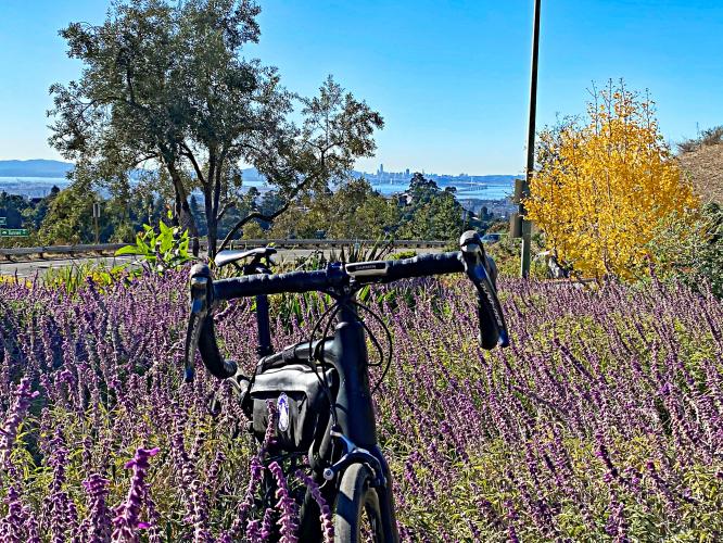
![Cycling Tunnel to Grizzly Peak, California Cycling Tunnel to Grizzly Peak, California - photo collage, Oakland Hills Fire Memorial Park, bike parked in purple wild flowers in front of bright yellow Gingko tree, bay area overlooking bay, PJAMM Cycling logo in corner]()
Start at the small but colorful Oakland Hills Fire Memorial Park.
Brief view of the Caldecott Tunnel and some spectacular views of the bay along the climb.
The Caldecott Tunnel, which connects Oakland and Orinda, opened in 1937 and is named after former Berkeley mayor Thomas Caldecott. This tunnel is cursed by fire: the 1982 Tunnel Fire killed seven people, and the Oakland Hills fire which began atop the tunnel killed 25.
![Cycling Tunnel to Grizzly Peak, California Cycling Tunnel to Grizzly Peak, California - climb start, bike parked against road sign at intersection on Tunnel Road]()
Climb start.
![Cycling Tunnel to Grizzly Peak, California Cycling Tunnel to Grizzly Peak, California - photo collage, bike parked against railing next to informational signs at the Oakland Hills Fire Memorial Park, wild flowers, bay views, PJAMM Cycling logo in corner]()
Begin climb at the Memorial to the 1991 Oakland Hills Fire.
The fire began at the west entry to the Caldecott Tunnel, one mile from climb start.
![Cycling Tunnel to Grizzly Peak, California Cycling Tunnel to Grizzly Peak, California - photo collage, bike parked against guardrail by street sign, road looks out over city and bay views, sign for winding road and cyclists, PJAMM Cycling logo in corner]()
Tunnel Road becomes Skyline Blvd at mile 1.5, as we pass over the Caldecott Tunnel.
![Cycling Tunnel to Grizzly Peak, California Cycling Tunnel to Grizzly Peak, California - grove of Australian Eucalyptus trees, bike parked at base of a giant tree]()
We pass a handsome grove of Australian Eucalyptus trees at mile 5.7.
In the early 1900’s capitalist and Berkeley resident Frank Colton Havens’ Mahogany Eucalyptus and Land Company began a eucalyptus farm and planted trees along 14 miles of the Berkeley-Oakland ridgeline (estimated at over 1,000,000 trees). The trees were planted in expectation of a lumber shortage, but, two problems: (1) the shortage never materialized and (2) it turned out eucalyptus is not suitable as a building material -- you’d think he would have figured that out a bit shy of 1m trees...??
![Cycling Tunnel to Grizzly Peak, California Cycling Tunnel to Grizzly Peak, California - bike parked against sign reading "Steam Trains"]()
Tilden South Gate and Pacific Railway is a 15” gauge 1¼ mile railway using 5” scale equipment with rides lasting roughly 12 minutes. As of 2018 ticket prices were $3 (children under 2 ride for free).
![Cycling Tunnel to Grizzly Peak, California Cycling Tunnel to Grizzly Peak, California - historical black and white railroad pictures]()
Photos: Steve Hadley, Walnut Creek
![Cycling Tunnel to Grizzly Peak, California Cycling Tunnel to Grizzly Peak, California - bike parked on hillside overlooking bay views, the Bay Bridge, the Golden Gate Bridge, and Mt. Tam all visible in the horizon]()
Trifecta at Grizzly Peak.
![Cycling Tunnel to Grizzly Peak, California Cycling Tunnel to Grizzly Peak, California - bike parked atop large, graffiti covered fallen log overlooking bay area views]()

 We've partnered with Sherpa-Map.com to bring you the best route planning tool. With a PRO Membership you can use this climb as a reference when creating your route.

