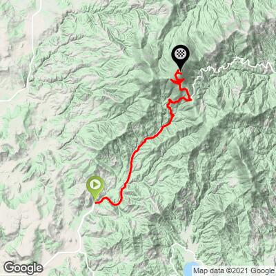
Mt. Spokane Bike Climb - PJAMM Cycling

7.6
FIETS
12.8 mi
DISTANCE
3,883 ft
GAINED
5.8 %
AVG. GRADE

FULL CLIMB STATS

Page Contributor(s): Bruce Hamilton, La Quinta, CA, USA; Stacy Topping, Tacoma, WA, USA

INTRO

Cycling Mt. Spokane - one of the top bike climbs in Washington. The roadway is heavily forested at the lower section, but the climb opens to nice views towards the top.  From the top you have views of the Spokane Valley, the north Idaho panhandle, and Canada. 
The crux of this climb is a challenging 3.4 mile segment averaging 9.55 beginning at mile 6.8.  4.7 miles (37%) of the climb is in the 0-5% gradient range, 49% (6.2 miles) is at grade 5-10%, and 1.4 miles (10.6%) is at 10-15%.  The climb's steepest quarter-mile is 11% and steepest continuous mile 9.9%.

See more details and tools regarding this climb's grade via the “Profile Tool” button.
Roadway:  Excellent condition with no shoulder, but the climb feels safe. 

Traffic:  Mild.

Parking:  We parked a few hundred yards south of the climb's start on E Bill Gulch Road for our climb - MapStreet View.
Provisions:  There are no provisions along the climb.  However, the Vista House (50 yards down gravel path north of climb finish) at the top may be open and if it is, check it out because it is an amazing structure and offers limited beverages and snacks. 
Before heading out on any cycling adventure check out our Things to Bring on a Cycling Trip and use our interactive check list to ensure you don't forget anything.
Be sure to visit the Vista House at the top of the climb if it is open - just a short walk down a gravel path north of the finish of the climb. 

Consider staying in the nearby college town of Spokane, where there are also many charming house rental options as well.

ROUTE MAP

MEMBER RATING

Difficulty: Extreme
3
Road
3.5
Traffic
3.5
Scenery

CURRENT WEATHER

PJAMM TRIPS ADVENTURE STARTER BUNDLES

Check out PJAMM Adventure's prepackaged (self-guided) cycling trips. They will help you plan, document and conquer your next adventure.
ALL TRIPS
Browse all of our prepackaged trips and find your next adventure!
Olympic NP: Hurricane Ridge
United States (WA), Canada
8 ROUTES
19 POIs
ROUTE STATS (TOTAL)
125
mi
DISTANCE
14,009
ft
ELEV. GAIN

NEARBY CLIMBS (0) RADIAL PROXIMITY

FROM
No Climbs Found

MEMBER REVIEWS & COMMENTS

Let us know what you thought of this climb. Signup for our FREE membership to write a review or post a comment.
Already have an account?

Aug 5, 2023
difficulty: Extreme
scenery: 3
traffic: 4
road: 4
Aug 5, 2023
scenery: 3
traffic: 4
road: 4
I found this climb to be far more challenging than it's rating, compared with other climbs I have done. It lures you in with gradual grade which slightly increases as you begin to tire. I'm glad I checked it off the list, but I wouldn't choose to do this one multiple times. There isn't anything that stands out to make this a regular climb. However, if you are in the Eastern Washington or North Idaho, it's worth the ride. I parked at the Yokes which is almost 22.5 miles from the top, making it a 45 mile round trip. The first 9.25 are flat or rolling, and then you are climbing for about 13.25
Jun 20, 2022
difficulty: Extreme
scenery: 4
traffic: 3
road: 2
Jun 20, 2022
scenery: 4
traffic: 3
road: 2
The technical climb up and threat of sliding off into the fast running creek just below really do set the men apart from the boys. Yes, the climb is daunting, dangerous even around the curves. The grade is rough, 5.1% at least four miles from the top. There is no dedicated bike lane, it's just a shared roadway with a skinny shoulder. Be careful and wear lights, high visibility clothing. The scenery really is breath-taking, but only when the clouds are low and set. It's all refreshing going up and I did so in high spirits. I did not see the Vista House towards the top. There is the Bear Creek Lodge on the way up that will have some useful sodas and candies potentially. It isn't far from where you start. I found a parking space not far below that but considering that the difference from the very, very bottom of the whole hill is 100 metres, I think that's totally acceptable.
ROUTE MAP
PROFILE TOOL
Route Data
S.G. (%)
hide
Segment Data
hide

Climb Profile Not Found
CLIMB SUMMARY

Cycling Mt. Spokane, Washington - cyclist riding on roadway surrounded by evergreen trees

Cycling Mt. Spokane, Park Drive and Summit Drive, Washington State.

Ride 12.8 miles gaining 3,989’ to elevation 5,838’ at 5.8% average grade.

“Mount Spokane is an excellent ascent up into the mountains of eastern Washington and is another contender for most difficult in the state. Containing an isolated start, the climb begins over shallow grade and on a narrow, tree lined road. The grade gradually increases as you ride over this tight and dark in places section but is never steep. Just over 6 miles in you reach the ranger station on the left and enter Mount Spokane State Park. It is here that the true nature of the climb is revealed. The grade immediately becomes more solid at this point and then eases a bit after just under another mile. Soon you encounter a big switchback and more solid and steady grade. Further up the hill the grade eases slightly and at the road junction turn left on Summit Road. This road is more narrow and with poor pavement (as of 2012) which gives the hill a real alpine feel. The first mile of Summit Road is more stout before the slope eases. The trees soon begin to thin and long vies appear on clear days. The narrow road runs right to the edge of the mountain with big exposure in spots. Toward the very top the grade eases and the climb ends just beyond a small parking area beside cell phone towers on top of the mountain (closed in winter - Mount Spokane State Park - 509-238-4258). Mount Spokane is a tricky descent in a few places and this climb is often used in area races.”  (This quote is presented with the approval of John Summerson, from his book, The Complete Guide to Climbing (by Bike), 2nd Edition, pg. 229.)

Cycling Mt. Spokane, Washington - photo collage, PJAMM Cycling logo in corner, cyclist wearing PJAMM Cycling jersey posing with bike on roadside, sign for Bottom Up Inn, wooden sign for Mitcham's Barn, old covered bridge

Come for the climb, stay for the descent.  We don’t usually lead with this, but for this one it’s appropriate – this is a Top 10 descent – smooth road, perfect serpentine roadway for much of the upper descent which, along with the steep grade, makes for a very exciting descent, one of the best for technical descending.  There are fantastic views to the south along the switchbacks beginning after turning onto summit road at mile 9.4.

Cycling Mt. Spokane, Washington - cyclists riding single file along two-lane highway, road sign for Mt. Spokane State Park, 8 Miles

Highway 206 on our way to the start of the climb.

Cycling Mt. Spokane, Washington - intersection of State Highway 206 and Big Gulch Road, cyclist riding by stop sign

Climb start.

During the lower portion of the climb we are surrounded by thick forest (and as noted above, bordered on one side by Bear Creek).  As we approach the last mile, the trees begin to thin and eventually disappear as we go above the treeline and approach the summit at Mt. Spokane Ski & Snowboard Park.  The final four miles on Summit Road are very pleasant with very mild traffic and a 25 MPH speed limit – you will not encounter many cars on this stretch of the road.

Cycling Mt. Spokane, Washington - "log bridge" along roadside, two large evergreen trees fallen along creek creating a bridge

Log bridge at mile 3.8.

Cycling Mt. Spokane, Washington - photo collage, PJAMM Cycling logo in corner, various roadsigns along roadway, creek bed running along roadside, golden wildflowers growing along roadway

Views and sites along the first half of the climb.

The State Park Service website writes of Mt. Spokane:

“Mount Spokane State Park is a 12,293-acre camping park in the Selkirk Mountains with 100 miles of trails and panoramic views from the summit of 5,883-foot Mount Spokane. In winter, the park receives approximately 300 inches of snow.”  

Cycling Mt. Spokane, Washington - Mt. Spokane State Park visitors center

Mile 5.9 -- Mt. Spokane Visitor Center.

Cycling Mt. Spokane, Washington - photo collage, PJAMM Cycling logo in corner, sign for Lost Woods, one-lane roadway winding up roadside with green grasses and evergreen trees along either side, cyclist climbing along roadside

Views and sites along the second half of the climb.

Cycling Mt. Spokane, Washington - lookout viewpoint along roadway, informational signs looking down upon mountain range and evergreen trees

Viewpoint at mile 8.4.

   Cycling Mt. Spokane, Washington - bike parked at viewpoint against low wooden fence overlooking green hillsides toward Idaho and Twin Lakes

View east towards Idaho and Twin Lakes.

This is a very calm and peaceful climb, pedalling alongside the year-round Bear Creek for most of the first seven miles.  THE climb (it’s in caps for a reason!) begins at approximately mile 7.4 with a 9.4% grade for about 3.3 miles. The initial and final segments of the climb are at very manageable grades.

Mt. Spokane is in the Selkirk Mountains, a subrange of the Canadian Rockies. The climb enters Mt. Spokane State Park at mile 5.8.  The State Park was established in 1927 and is 12,293 acres.

Roadway Surface and Traffic Report:  The roadway is very good throughout, although the last few miles are a bit rougher than the excellent roadway on Mt Spokane Road.  Make sure to turn left (left is “up” and onto Summit Road, and right/straight is “down” and continuing on Mt. Spokane Riad) at mile 9.4.  From this point, you’ll have four miles to go.  

From PJAMM Contributor  Patrick O'Neil, Spokane WA:


“Race The Sun” may refer to an evening ride where the goal is to reach the summit before sunset. This particular segment includes the relatively flat section from Forker Road.  The actual climb is a beautiful 10 miles of 6-12% climbing through the forested Mt. Spokane. A creek runs next to the climb in the lower sections. Traffic is usually light and patient. One of the great features of this climb is it constantly undulates back and forth, always giving you something new to challenge yourself. The top rewards you by flattening out and with views of all around the Spokane area and east into Idaho. Part of its "epic" nature is just knowing how many riders make this climb. It has been used many years as a local hill climb race battle that we all enjoy.

From PJAMM contributor Bob Britton, Spokane, WA:  

Mt. Spokane is located in eastern Washington (the dry side), near beautiful Spokane and is also the the location of Washington state’s largest state park. The way up starts on Highway 206, also known as Mt. Spokane Park Drive. I like to start well before "The Climb" to soak up some of the beautiful pastoral scenes and good views of Mt. Spokane. Orient yourself and explore segments embedded along the route beforehand. The road gently winds upward through heavily forested terrain following Deadman Creek drainage. The creek’s waters are often just a few yards off the road and the sounds of the dancing water adds to a calm coolness for a number of miles. The real climbing starts at the park entrance where grades kick up from 2%-5% to 8%-10% with few painful 11% punches mixed in. Once you reach a large gravel parking area you will take a hard left turn with four more more miles to go. The grades for the next mile are the steepest of the climb, but take heart as they are followed by some relatively easy grades. The views now really start to open up. The road makes several long traverses again affording some very nice territorial views. The towers above that come into site are your goal. Once at the top take time to gather in what I believe is some of the finest scenery in the country. There is a bathroom and water at the top. Use caution going down as there are a number of dips that are hard to see coming that could launch a rider out of control. Cheers!

Access to full Climb Summary requires a PJAMM Cycling PRO Membership!

It takes less than a minute to sign up & with your PRO membership you can:
  • Rate climbs, post comments and share your experiences on any of our climb pages
  • Create bucket lists of climbs & mark the dates you complete them
  • Weather data for all climbs - Start & Finish
  • Upload photos to your member page to customize your PJAMM Cycling experience
  • Utilize all of our interactive tools - Profile & Routes in Area
  • Download climb route .gpx files
LEARN MORE
SIGN UP

Already have an account? LOG IN HERE