

16.2
PDI
23.1 mi
DISTANCE
4,388 ft
GAINED
2.4 %
AVG. GRADE
FULL CLIMB STATS
Page Contributor(s): Ard Oostra, Montreux, Switzerland
INTRO
The last 10 km of this ride look nothing like the first 27. You start among the farms and birch woods of Valdres and finish on a bare, windswept plateau at nearly 1400 m, with lakes, ice-age boulders and the first peaks of Jotunheimen all around you and not a tree in sight.
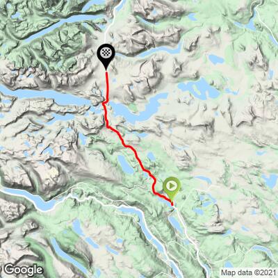
It's a long climb rather than a steep one: 37.1 km (23.1 mi) from Heggenes at 477 m to 1380 m (1566 to 4528 ft), close to the 1389 m (4557 ft) high point of the road, with 1337 m (4388 ft) of climbing. The average is only 2.4%, partly because of a few rolling stretches and a 100 m drop to Lake Bygdin. The first half climbs steadily out of the valley to Beitostølen, the ski village at about 900 m. Above it the trees thin out and the road works its way above the tree line, and after Bygdin comes the steepest part, with the hardest kilometer around km 33 averaging 7.6%.
Up on Valdresflye, it's the weather that decides how hard the day is. There's nothing to break the wind, and a headwind on the plateau can feel like another climb. On a clear day, though, with Bitihorn standing over Bygdin and snow still on the peaks, it's one of the best places to ride a bike in Norway.
PLAN YOUR ROUTE
 We've partnered with Sherpa-Map.com to bring you the best route planning tool. With a PRO Membership you can use this climb as a reference when creating your route.
Valdresflya South climbs 1337 m (4388 ft) over 37.1 km (23.1 mi), from Heggenes at 477 m (1566 ft) to the plateau at 1380 m (4528 ft), with about 435 m (1426 ft) of downhill mixed in. The average works out to 2.4%.
The first 5 km rise steadily at 2.5-5.5%, then the road rolls for 8 km, with two short descents, to about 725 m. From km 13 it climbs consistently at 3-5% through Beitostølen and above the tree line to about 1155 m near km 24.
From there it drops about 100 m to Bygdin before the last climb: 9 km from 1057 m to 1380 m, with the steepest kilometer of the route (7.6%) around km 33. The steepest 2 km average 6.1% and the steepest 5 km 5.4%.
Roadway: Asphalt throughout on the Fv51, a two-lane road in decent condition. North of Beitostølen, the section between Garli and Maurvangen closes in winter, so the full climb is a spring-to-early-winter ride: in recent seasons the road has opened in late March or early April (30 March in 2026) and shut again in mid-December or early January - the county closes it at the first storm after 15 December that the ploughs can't keep up with. Even after it opens, a barrier at Garli can close the road overnight and in bad weather, and spring rides come with high snowbanks on both sides. Check Statens vegvesen's road report (or the yr.no mountain pass page for Fv51 Valdresflye) before you go.
Traffic: Moderate in summer. The Fv51 is the road from Valdres to Gjende and Vågå, so July and August bring a steady flow of cars, campervans and motorbikes, and it can be heavy at times. It's quieter early in the morning and outside the summer holidays. Between Heggenes and Beitostølen it's mostly local traffic.
Parking: Heggenes is small, so the easiest plan is to stay in Beitostølen, about 17 km up the route, and roll down to the start. The Flye 1389 rest area at the high point has parking if you're meeting a support car or leaving one there.
Gear: Nothing here needs low gearing - a compact with a 28-tooth cog is plenty. Clothing is the bigger question: the plateau is exposed, the weather turns fast, and it's much colder up there than in the valley. Bring a waterproof jacket, gloves and leg warmers for the descent.
Provisions: Beitostølen, about 17 km in, has shops and cafes. The old mountain hotel at Bygdin sits beside the road at the lake, and at the high point the Flye 1389 café, built in 2020 next to the Valdresflya hostel, serves waffles and local food in season. Outside the summer season don't count on either, and pack food and water for the whole ride.
Before heading out on any cycling adventure check out our Things to Bring on a Cycling Trip and use our interactive check list to ensure you don't forget anything.
Beitostølen is the base: a ski village with hotels, cabins and shops right on the route. From Valdresflye, the Fv51 continues north to Gjende, the start of the Besseggen ridge hike - our Valdresflya North page climbs the road from that side.
For a rest day, the motorboat M/B Bitihorn, built in 1912, sails from Bygdin wharf along the lake to Eidsbugarden in late June, July and August. The mountain dairy farms along the road sell their own butter, sour cream and cheese - worth a stop as you come back past.
If you ride over the top rather than back, a summer bus runs along the Fv51 from June to September; check timetables on en-tur.no before you rely on it.
ROUTE MAP
MEMBER RATING
CURRENT WEATHER
PJAMM TRIPS ADVENTURE STARTER BUNDLES
Check out PJAMM Adventure's prepackaged (self-guided) cycling trips. They will help you plan, document and conquer your next adventure.
NEARBY CLIMBS (0) RADIAL PROXIMITY
FROM No Climbs Found
MEMBER REVIEWS & COMMENTS
Let us know what you thought of this climb. Signup for our FREE membership to write a review or post a comment.
Already have an account?
LOG IN HERE
