16.1
PDI
23.3 mi
DISTANCE
4,089 ft
GAINED
3 %
AVG. GRADE
FULL CLIMB STATS
Page Contributor(s): Brude Hamilton, La Quinta, CA, USA; Stacy Topping, Tacoma, WA, USA
INTRO
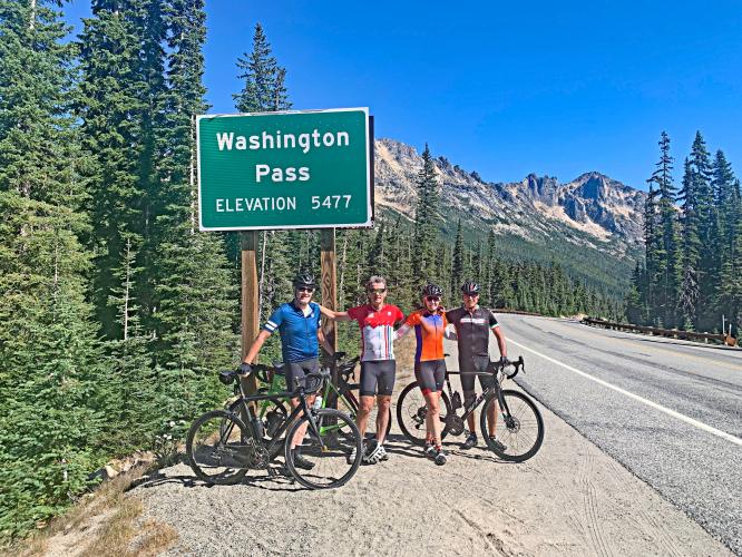
This 23.3 mile bike climb is located in WA, USA. The average gradient is 3% and there is a total elevation gain of 4,089 ft, finishing at 5,448 ft.
Use the profile tool, route map, and weather forecast to conquer this cycling climb.
Use the profile tool, route map, and weather forecast to conquer this cycling climb.
PLAN YOUR ROUTE
See more details and tools regarding this climb's grade via our interactive Profile Tool.
Information Not Available
If you have any information regarding this climb, we'd like to hear from you. Click the CONTRIBUTE button to share your thoughts with us.
Information Not Available
If you have any information regarding this climb, we'd like to hear from you. Click the CONTRIBUTE button to share your thoughts with us.
Before heading out on any cycling adventure check out our Things to Bring on a Cycling Trip and use our interactive check list to ensure you don't forget anything.
Information Not Available
If you have any information regarding this climb, we'd like to hear from you. Click the CONTRIBUTE button to share your thoughts with us.
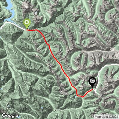
ROUTE MAP
MEMBER RATING
CURRENT WEATHER
PJAMM TRIPS ADVENTURE STARTER BUNDLES
Check out PJAMM Adventure's prepackaged (self-guided) cycling trips. They will help you plan, document and conquer your next adventure.
NEARBY CLIMBS (0) RADIAL PROXIMITY
FROM No Climbs Found
MEMBER REVIEWS & COMMENTS
Let us know what you thought of this climb. Signup for our FREE membership to write a review or post a comment.
Already have an account?
LOG IN HERE
MethowBiker
Like all climbs in WA, I strongly recommend NOT doing this on any summer weekend. There will be nonstop traffic from Colonial Creek all the way to WA Pass and down to Mazama. Noisy. And the shoulder kind of sucks in a lot of places so you'll want to take the lane. The best time to do this is in spring (April and early May), BEFORE the road is opened to traffic (this also applies to starting from Winthrop and going west). Then, you can only ride it on Sat and Sun, but you'll have no cars. If you can't do that, do it before mid-June or after Labor Day. This is a long climb, but very easy for most of the distance. The crux is the 2 mile uphill after you descend from Rainy Pass, where you'll have a 10-11% ramp for a mile. The only bathroom is at Wash Pass (great view, ~1/2 mile off of Route 20). No water, no services, no cell phone service. The scenery is terrific. The area is called "America's Alps". Pick a time to ride this when you can enjoy the scenery quietly.
djoneswa


I camped at Colonial Creek Campground and climbed the 32 miles to Washington Pass late in May. Total was just over 6,000 of climbing.
This is a very scenic and well-maintained route, with polite traffic. The first 3 miles are the steepest, but the grade is generally steady. I hit snow at 5,000' and it began to rain when I crested Rainy Pass, which is 5 miles before the top at Washington Pass. Watch for strong side winds, which can also be impressive headwinds on the descent.
Throughout you will climb with the sound of rushing water and bird calls, and see frequent vistas opening up to the north almost into Canada.
There is no water access on the route, so take what you will need, or drink from one of those waterfalls.
RyanH
Great!